Welcome to Visit Castlemilk Places
The Walkfo guide to things to do & explore in Castlemilk
 Visit Castlemilk places using Walkfo for free guided tours of the best Castlemilk places to visit. A unique way to experience Castlemilk’s places, Walkfo allows you to explore Castlemilk as you would a museum or art gallery with audio guides.
Visiting Castlemilk Walkfo Preview
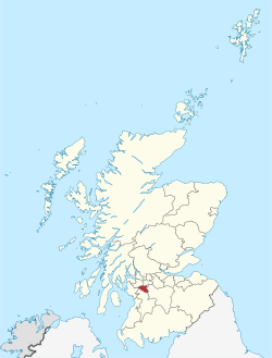
Castlemilk (Scottish Gaelic: Caisteal Mheilc) is a district of Glasgow, Scotland. It lies to the far south of the city centre, adjacent to the Croftfoot and Simshill residential areas within the city. The area was developed by the Glasgow Corporation as a peripheral housing scheme in the 1950s to accommodate 34,000 people from inner-city slum areas such as the Gorbals. When you visit Castlemilk, Walkfo brings Castlemilk places to life as you travel by foot, bike, bus or car with a mobile phone & headphones.
Castlemilk Places Overview: History, Culture & Facts about Castlemilk
Visit Castlemilk – Walkfo’s stats for the places to visit
With 83 audio plaques & Castlemilk places for you to explore in the Castlemilk area, Walkfo is the world’s largest heritage & history digital plaque provider. The AI continually learns & refines facts about the best Castlemilk places to visit from travel & tourism authorities (like Wikipedia), converting history into an interactive audio experience.
Castlemilk history
Early history
The Stuarts sold their Dumfriesshire estate of Castlemilk to Lord Maxwell in 1579. Some sources give the date of this development as 1759. Other sources give it as Cassiltoun, the Lanarkshire property of Cassiloun. During the 18th Century, the valuable estate of Milton on the north side of Glasgow came by marriage into the possession of the family.
Development of modern estate

Castlemilk and the other peripheral housing schemes in Glasgow had their origins in the city’s housing crisis after the end of the Second World War. Many inner city areas such as Hutchesontown contained street after street of sub-standard tenement housing, and the city as a whole had a shortage of affordable good quality accommodation. The Castlemilk estate had already been acquired for building by the Glasgow Corporation under a compulsory purchase order in 1936, prior to the war. In 1947, a delegation from Glasgow visited Marseille to see the new social housing designed by the Swiss-French architect Le Corbusier, who was a pioneer of modern urban planning. The group examined how his ideas could be applied to Glasgow with the proposed development of new “townships” on the outskirts of the city. Around the same time a second strategy was also formulated for the dispersal of the city’s population, this being new towns such as East Kilbride (which is only a few miles across countryside from Castlemilk). However, the city fathers were anxious to ensure that most people remained living within the Glasgow boundaries so they keenly pursued the townships project even with limited space available on which to build. The other areas identified for this were Pollok, Drumchapel and Easterhouse – collectively referred to along with Castlemilk as “the big four”. In December 1952, Glasgow Corporation approved a sketch layout plan for the construction of a new township at Castlemilk with an estimated cost of £16,000,000. It was planned to ultimately comprise some 8,300 houses. In early 1953, more detailed plans for the development of Castlemilk were prepared by Archibald George Jury, who had been appointed as Glasgow’s first City Architect in 1951, a post he held until his retirement in 1972. There was a very limited range of different house types planned for the initial Castlemilk scheme. Most of the accommodation was to be contained in three or four-storey tenement blocks. There were also to be three-storey terraced houses intended for larger families and a few other house types designed for the elderly and other groups such as the local fire service personnel. The original 1950s flats, entered from common closes, seem to have been designed as modern versions of the traditional Glasgow tenements. Unlike many of the Victorian tenement dwellings, however, these flats came with interior bathrooms and running hot and cold water. Many of the street names (Ardencraig, Ardmaleish, Birgidale, Dougrie, Dunagoil, Machrie) were derived from rural locations in the County of Bute. The multi-storey blocks in Castlemilk did not arrive until the 1960s. Built after the added amenities that included: a swimming pool, the shopping arcade and the community centre. Archibald Jury was the architect responsible for the creation of the three 20-storey tower blocks in Dougrie Road, from the planning stage in 1960 to their completion in 1966 (these are still standing). The Mitchelhill high-rise blocks at Ardencraig Road, built on high and exposed ground at the edge of the Cathkin Braes and designed to be a prominent feature of the city skyline, were designed and built by George Wimpey Ltd, between 1963 and 1965 (they were demolished in 2005); Wimpey was also responsible for the construction of Bogany Flats in 1966 (demolished as early as 1993). Public housing policy in Scotland was radically changed by the Tenants’ Rights, Etc. (Scotland) Act 1980, which gave tenants the right to buy their council houses for the first time. Since then, renovation, demolition and refurbishment of Castlemilk’s existing housing stock has taken place, as well as the development of areas of new build houses for owner-occupation. Tenure has diversified with home ownership transferred from the City Council to local Housing Associations and owner-occupiers. The township centre at Castlemilk Arcade / Dougrie Drive was developed by Ravenseft Properties Ltd between 1961 and 1963 on a 5-acre (20,000 m) site which was formerly the location of the large country houses at Castleton, west of Castlemilk House itself. The centre was designed to contain about sixty shops at an estimated cost of £3m to £4m. The shops are still standing, with an 80% occupancy rate. The north side of the arcade on Dougrie Drive contains Castlemilk’s only pub, the Oasis. After the shopping centre’s small Co-op Food supermarket confirmed it would closed its doors in 2016, residents launched a campaign for improved grocery shopping provision in the district, with local bodies failing to attract any suitable tenants for either the Braes Centre (described by campaigners as badly outdated) or at any new standalone sites. The original neighbourhood shops were built at the ground floors of the tenement blocks, following the old Glasgow pattern. Ownership of these small shops has been transferred from the Council to the Glasgow Housing Association, who have let the surviving blocks of shops in Stravanan Road and Tormusk Road to various tenants. Castlemilk House was demolished in 1969 after being used as a children’s home for several years and then falling derelict. The accompanying stables block (built 1794, designed by David Hamilton and Category B listed) survived and was restored; it now contains the local housing offices, community facilities and a nursery. The green areas between the clusters of housing, including the old features of the Castlemilk House estate, are managed as a Park and Woodlands, an award-winning project aimed to benefit the community. Unlike some amenities, schools were in the Castlemilk plans from its conception. Eight primary schools served the area, with some of them closing and merging going into the 21st century – there are now four: Miller, Castleton, St Bartholomew’s RC and John Paul II RC, plus one special school, Kirkriggs. Glenwood Secondary School was the first of the scheme’s three high schools to be constructed in 1958, followed by the (Catholic) St Margaret Mary’s Secondary School in 1962 and Grange Secondary School in 1968. Falling population numbers led to Glenwood closing its doors in 1990 (a business centre now occupies the site) and the pupils transferring to Grange, which was renamed Castlemilk High School. In 2001 that school was rebuilt on a smaller scale on the same site, with the playground and buildings swapping places; St Margaret Mary’s was reconstructed in 2002 using the same method. Some children living in the north-west of Castlemilk attend King’s Park Secondary School in the neighbouring Simshill district, whilst the village school in Carmunnock is affiliated to Castlemilk High. In 2001, the Reverend John D. Miller, minister of Castlemilk East Parish Church (from 1971 until his retirement in 2007), was elected Moderator of the General Assembly of the Church of Scotland. Miller Primary School in Castlemilk was named after him and his wife. As part of the regeneration of Castlemilk in 1999, several public artworks were commissioned and placed at prominent entrances into the area; these included works by sculptors Kenny Hunter and Rick Kirby.
Why visit Castlemilk with Walkfo Travel Guide App?
 You can visit Castlemilk places with Walkfo Castlemilk to hear history at Castlemilk’s places whilst walking around using the free digital tour app. Walkfo Castlemilk has 83 places to visit in our interactive Castlemilk map, with amazing history, culture & travel facts you can explore the same way you would at a museum or art gallery with information audio headset. With Walkfo, you can travel by foot, bike or bus throughout Castlemilk, being in the moment, without digital distraction or limits to a specific walking route. Our historic audio walks, National Trust interactive audio experiences, digital tour guides for English Heritage locations are available at Castlemilk places, with a AI tour guide to help you get the best from a visit to Castlemilk & the surrounding areas.
“Curated content for millions of locations across the UK, with 83 audio facts unique to Castlemilk places in an interactive Castlemilk map you can explore.”
Walkfo: Visit Castlemilk Places Map
83 tourist, history, culture & geography spots
Castlemilk historic spots | Castlemilk tourist destinations | Castlemilk plaques | Castlemilk geographic features |
| Walkfo Castlemilk tourism map key: places to see & visit like National Trust sites, Blue Plaques, English Heritage locations & top tourist destinations in Castlemilk | |||
Best Castlemilk places to visit
Castlemilk has places to explore by foot, bike or bus. Below are a selection of the varied Castlemilk’s destinations you can visit with additional content available at the Walkfo Castlemilk’s information audio spots:
East Renfrewshire
East Renfrewshire is one of 32 council areas of Scotland . Until 1975, it formed part of the county of Renfreyshire for local government purposes . It was formed in 1996 as a successor to the Eastwood district, with the Levern Valley being annexed .

Muirend
Muirend is situated about 4 miles (6.5 km) south of Glasgow city centre. The G44 postcode was rated as the most desirable area of Scotland to live in. Neighbouring areas include Cathcart, Merrylee and Newlands.

Cathcart Cemetery
Cathcart Cemetery is a cemetery in East Renfrewshire, Scotland, which was opened in 1878 . It is named after the nearby neighbourhood of Cathcart on the southern outskirts of Glasgow, but does not actually fall within the city boundaries .

Burnside railway station
Burnside railway station serves the Burnside and Blairbeth areas of the Royal Burgh of Rutherglen, South Lanarkshire, Greater Glasgow, Scotland . The station is located on the Newton branch of the Cathcart Circle Lines, which has been electrified since 1962 by British Railways .

West Whitlawburn Housing Co-operative
West Whitlawburn Housing Co-operative is a housing co-operative and registered social landlord on the outskirts of Glasgow, Scotland. Founded in 1989 it is one of the largest co-operatives in Scotland. The tenants are members and shareholders and elect a management committee.
A730 road
A730 road in Scotland runs between the centre of Glasgow and the south-eastern edge of the city’s urban area at Cathkin.
Visit Castlemilk plaques
 8
8
plaques
here Castlemilk has 8 physical plaques in tourist plaque schemes for you to explore via Walkfo Castlemilk plaques audio map when visiting. Plaques like National Heritage’s “Blue Plaques” provide visual geo-markers to highlight points-of-interest at the places where they happened – and Walkfo’s AI has researched additional, deeper content when you visit Castlemilk using the app. Experience the history of a location when Walkfo local tourist guide app triggers audio close to each Castlemilk plaque. Explore Plaques & History has a complete list of Hartlepool’s plaques & Hartlepool history plaque map.


 Trying to encourage visitors to Castlemilk?