Welcome to Visit Carlton Hill, Brighton Places
The Walkfo guide to things to do & explore in Carlton Hill, Brighton
 Visit Carlton Hill, Brighton places using Walkfo for free guided tours of the best Carlton Hill, Brighton places to visit. A unique way to experience Carlton Hill, Brighton’s places, Walkfo allows you to explore Carlton Hill, Brighton as you would a museum or art gallery with audio guides.
Visiting Carlton Hill, Brighton Walkfo Preview
Carlton Hill is an inner-city area of Brighton, part of the English city and seaside resort of Brighton and Hove. It was first developed in the early and mid-19th century on steeply sloping farmland east of central Brighton. By the early 20th century the area was Brighton’s worst slum: overcrowding, crime and disease were rife. Extensive slum clearance in the mid-20th century introduced high-density tower blocks, but some old buildings remain. When you visit Carlton Hill, Brighton, Walkfo brings Carlton Hill, Brighton places to life as you travel by foot, bike, bus or car with a mobile phone & headphones.
Carlton Hill, Brighton Places Overview: History, Culture & Facts about Carlton Hill, Brighton
Visit Carlton Hill, Brighton – Walkfo’s stats for the places to visit
With 212 audio plaques & Carlton Hill, Brighton places for you to explore in the Carlton Hill, Brighton area, Walkfo is the world’s largest heritage & history digital plaque provider. The AI continually learns & refines facts about the best Carlton Hill, Brighton places to visit from travel & tourism authorities (like Wikipedia), converting history into an interactive audio experience.
Carlton Hill, Brighton history

Brighton’s origins lie in the Saxon fishing and agricultural village of Bristelmestune. The English Channel formed its southern limit, but on all other sides was farmland divided into open fields called laines. These were further subdivided into furlongs—wide parallel strips—and paul-pieces, which were much narrower strips. Despite their small size, neighbouring paul-pieces often had different owners. Wide paths (leakways) ran at right-angles to the furlongs, separating them. This ancient land-use pattern, which survived until the 18th century despite its unsuitability for contemporary farming methods, significantly influenced the pattern of urban development in 18th- and 19th-century Brighton. Hilly Laine was one of Brighton’s five laines. It was northeast of the Steine (later called Old Steine), the centre of fashionable society in the 18th century, and rose steeply eastwards from an area of sheltered flatter land close to the Steine. Some fields were used for small-scale activities such as limeburning and market gardening, but most were farmed by individuals. The laine had several furlongs; the second of these, which now forms the heart of the conservation area, was separated from its neighbours by leakways which became Carlton Hill (the road) and Sussex Street. Much of the land in this area was owned by Dr Benjamin Scutt, whose landholdings extended into the neighbouring village of Hove (the Brunswick estate was built on land he sold in the 1820s). Starting around 1800, the land was gradually sold to developers; Edward Street was laid out in 1804 and quickly experienced a “mini building boom” with inns, stables and small workshops. John Street, on the first (westernmost) furlong of Hilly Laine, was built up by 1810: its developer, John Hall, laid out plots for 11 by 15 feet (3.4 m × 4.6 m) houses and started building and selling them in 1805. Carlton Street, by another developer, followed by 1807. Meanwhile, development continued slowly on the second furlong: four paul-pieces were occupied with buildings by 1819. Scutt’s land sales helped him fund the development of Carlton Place, an architectural set-piece consisting of a 20-house terrace surrounding a riding school, the Royal Circus; the development took place between 1806 and 1808. Named after Carlton House, the Prince Regent’s London home, the development was on a larger scale than the rest of Carlton Hill’s houses: each plot measured 17 by 60 feet (5.2 m × 18.3 m). Each cost about £410 (£33,000 in 2021) to build, and proved to be profitable: one sold for £700 (£57,000 in 2021) in 1806 to a local vicar, who later bought two more to rent out. A survey of the town’s housing by the Brighton Town Commissioners in 1814 valued Carlton Place within the top 25% of all houses in Brighton. Scutt laid out three more streets nearby at the same time: Carlton Mews, Carlton Row and Woburn Place were narrow roads crowded with small houses, stables and workshops. Meanwhile, a farmhouse was built at an unknown time in the early 19th century on nearby Mighell Street; it may have moved from agricultural to residential and commercial use later that century, and has an obscure early history. Built as Patriot Place in the mid-1810s, Tilbury Place (renamed in the 1860s) and its five houses stood next to the farm and formed a pocket of high-class residential development in a mostly working-class area of small houses. Number 1, also called St John’s Lodge, was the largest, and was built for Edward Tarner (a merchant) and his wife Letitia, whose maiden name was Tilbury. It passed through the family until 1933, when Letitia Tilbury Tarner, a descendant, left it to her cousin Clara Isabella Bryan, who sold it in 1938 to Brighton Corporation for charitable purposes. It was converted into Tarner Home, a nursing and care institute for poor people, and later became a hostel. Nos 1-5 Tilbury Place are now owned by a housing association and used as housing. Apart from some land north of Sussex Street that remained agricultural until the 20th century, the whole hillside was covered with (mostly terraced) houses, small workshops and industrial structures, inns and other modest buildings by the mid-19th century. As early as 1840, the area was considered to be affected by poverty and its high population density. Brighton Corporation undertook some slum clearance in the 1880s, when White and Blaker Streets were laid out between Carlton Hill and Edward Street. By this time, Carlton Hill was known as Brighton’s “foreign quarter”, where many Italian and French street vendors—who sold food of various types on Brighton beach, in the town centre and from door to door—settled. Brighton’s fishing industry still thrived into the early 20th century, and many fishermen lived in Carlton Hill and used its workshops and warehouses to cure and smoke their herring catches. A contemporary writer, quoted by Brighton historian Clifford Musgrave, observed that “an aromatic and appetising pall would envelop the entire neighbourhood, kippering both fish and residents alike”. In the late 19th century and early 20th century, Carlton Hill’s notoriety as a slum increased. Poverty, drunkenness, disease and low living standards were rife. Brighton’s reputation was damaged by a disparaging article in The Lancet in 1882: making reference to Carlton Hill, it criticised the town’s poor standards of health. Assisted by government funding, Brighton Corporation undertook extensive slum clearance from 1928 until the start of World War II, transforming the area’s appearance. Two large blocks of flats—Brighton Corporation’s first council flats—were built to rehouse many of the displaced residents. The Milner Flats, a long four-storey block, stand on the site of Woburn Place, and were completed in 1934. Alderman Hugh Milner Black, a Corporation member who campaigned for housing improvements in Brighton, was commemorated in the naming. Kingswood Flats, on the site of Nelson Place and a Primitive Methodist chapel, were built in 1938. The name refers to Minister for Health Kingsley Wood. Some displaced residents were moved out of the area: the new council estates of Whitehawk and Moulsecoomb, built in the 1920s and early 1930s on the fringe of Brighton, accommodated many former Carlton Hill residents. An earlier low-rise development took place in 1931, when the small Tarnerland council estate was built on empty land near Tilbury Place. The Corporation also provided non-residential buildings on the cleared land. The Circus Street Municipal Market, on a wide street built behind Scutt’s Royal Circus riding school, opened in January 1937 and became one of Brighton’s main markets. A former chapel and many terraced houses had stood on the site, whose redevelopment cost £75,000 (£4,875,200 in 2021). A fish market, moved from a site near the beach, was added in 1960. The building closed in 2005 and has been empty since then, apart from its use as a temporary exhibition centre during the 2009 Brighton Festival—when sculptor Anish Kapoor showed a new work there. Two clinics, specialising in chest complaints and child welfare, opened on the north side of Sussex Street, opposite the market, in 1936 and 1938 respectively. The chest clinic closed in 1989. The lower part of Sussex Street was renamed Morley Street at this time. Brighton Corporation compulsorily purchased Carlton Place in about 1955 and demolished the houses and former riding school in favour of new housing. John Street became the site of two important civic buildings in the mid-1960s: Brighton’s central police station was opened in 1965, followed by the new county court building two years later. Clearances around Albion Hill began in the 1950s. From 1959, the narrow, densely populated terraces between Albion Hill and Morley Street were cleared and replaced with landscaped open space and seven tower blocks—Brighton’s first such buildings. The first, Highleigh, opened on 11 May 1961. Like its later neighbours, it has 11 storeys. The steep Richmond Street was severed as part of this redevelopment; its lower section was replaced by a zig-zag path down the hillside and a short road called Richmond Parade, and new roads (Grove Hill and Ashton Rise) were built between the tower blocks and across the slope of the hill. Similarly, the lowest section of Carlton Hill was renamed Kingswood Street when it was redeveloped in the 1960s: Brighton Art College (now part of the University of Brighton) was extended in 1967 by Brighton borough architect Percy Billington, taking up a large corner plot. In the mid-1970s, American Express sought land in Brighton to build a new European headquarters. The company had a long association with Sussex, and opened a mechanical accounting centre in a building on Edward Street in 1968. Most of Mighell Street and all of its buildings—except the old farmhouse—and some neighbouring streets were demolished and replaced by the 300,000-square-foot (28,000 m) Amex House, a nine-storey office building designed by American architecture firm Gollins, Melvin, Ward and Partners. A legislative order was raised by the Secretary of State for the Environment in mid-1973 to allow Mighell Street to be severed. In September 2008, American Express announced plans to demolish and replace the building. The new office is set slightly further back, closer to Carlton Hill (the road), and better road access will be provided by means of a new entrance from John Street. The city council granted planning permission in November 2009, and preliminary building work started in early 2010. The work was completed in 2012 and the old Amex House was demolished in 2017.
Why visit Carlton Hill, Brighton with Walkfo Travel Guide App?
 You can visit Carlton Hill, Brighton places with Walkfo Carlton Hill, Brighton to hear history at Carlton Hill, Brighton’s places whilst walking around using the free digital tour app. Walkfo Carlton Hill, Brighton has 212 places to visit in our interactive Carlton Hill, Brighton map, with amazing history, culture & travel facts you can explore the same way you would at a museum or art gallery with information audio headset. With Walkfo, you can travel by foot, bike or bus throughout Carlton Hill, Brighton, being in the moment, without digital distraction or limits to a specific walking route. Our historic audio walks, National Trust interactive audio experiences, digital tour guides for English Heritage locations are available at Carlton Hill, Brighton places, with a AI tour guide to help you get the best from a visit to Carlton Hill, Brighton & the surrounding areas.
“Curated content for millions of locations across the UK, with 212 audio facts unique to Carlton Hill, Brighton places in an interactive Carlton Hill, Brighton map you can explore.”
Walkfo: Visit Carlton Hill, Brighton Places Map
212 tourist, history, culture & geography spots
Carlton Hill, Brighton historic spots | Carlton Hill, Brighton tourist destinations | Carlton Hill, Brighton plaques | Carlton Hill, Brighton geographic features |
| Walkfo Carlton Hill, Brighton tourism map key: places to see & visit like National Trust sites, Blue Plaques, English Heritage locations & top tourist destinations in Carlton Hill, Brighton | |||
Best Carlton Hill, Brighton places to visit
Carlton Hill, Brighton has places to explore by foot, bike or bus. Below are a selection of the varied Carlton Hill, Brighton’s destinations you can visit with additional content available at the Walkfo Carlton Hill, Brighton’s information audio spots:
 | St Wulfran’s Church, Ovingdean St Wulfran’s Church is an Anglican church in Ovingdean, a rural village now within the English city of Brighton and Hove. The church is listed at Grade I, a designation used for buildings “of outstanding architectural or historic interest” |
 | St Luke’s Church, Queen’s Park, Brighton St Luke’s Church is an Anglican church in the Queen’s Park area of Brighton. It was designed in the 1880s by Sir Arthur Blomfield in the Early English style. It has been given listed building status because of its architectural importance. |
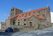
 | Greek Orthodox Church of the Holy Trinity, Brighton The Church of the Holy Trinity is a Greek Orthodox church in Brighton. Built in 1838 in one of Brighton’s most notorious slum districts, Carlton Hill. It was an Anglican church for most of its life until it was declared redundant in 1980. It has been listed at Grade II since 1971. |
 | St Mary the Virgin, Brighton St Mary’s Church is an Anglican church in the Kemptown area of Brighton. The present building dates from the late 1870s and replaced a church of the same name which collapsed while being renovated. The Gothic-style red-brick building is now a Grade II* listed building. |
 | Church of the Annunciation, Brighton The Church of the Annunciation was built in the 1860s on behalf of Rev. Arthur Wagner. It served a new area of poor housing in what is now the Hanover district. The church is a Grade II listed building. |
 | Royal Crescent, Brighton Royal Crescent is a crescent-shaped terrace of houses on the seafront in Brighton, part of the English city of Brighton and Hove. Built in the late 18th and early 19th century as a speculative development on the open cliffs east of Brighton by a wealthy merchant. English Heritage has listed the crescent at Grade II* for its architectural and historical importance. |
 | Waste House Waste House is a building on the University of Brighton campus in the centre of Brighton on the south coast of England. It was built between 2012 and 2014 as a project involving hundreds of students and apprentices. The materials consist of a wide range of construction industry and household waste. It is the first public building in Europe to be built primarily of such products. |
 | St Wilfrid’s Church, Brighton St Wilfrid’s Church is a former Anglican church in the Elm Grove area of Brighton, part of the English city of Brighton and Hove. It was declared redundant after less than 50 years as a place of worship, and was converted into sheltered housing with minimal alteration to the exterior. |
 | Dorset Gardens Methodist Church Dorset Gardens Methodist Church is the third Methodist place of worship on the site. It replaced an older, larger church which was in turn a rebuilding of Brighton’s first Methodist church. Between them, the churches have played an important part in the history of Methodism in Brighton. |
 | The Blind Tiger Club, Brighton The Blind Tiger Club was a mixed music, arts and community venue in Brighton, England, which opened in 2010. Time Out described the venue as “semi-legendary”, in its round-up of Brighton’s live music scene that year. Gigwise included the club in their list of the UK’s Greatest Lost Venues. |
Visit Carlton Hill, Brighton plaques
 150
150
plaques
here Carlton Hill, Brighton has 150 physical plaques in tourist plaque schemes for you to explore via Walkfo Carlton Hill, Brighton plaques audio map when visiting. Plaques like National Heritage’s “Blue Plaques” provide visual geo-markers to highlight points-of-interest at the places where they happened – and Walkfo’s AI has researched additional, deeper content when you visit Carlton Hill, Brighton using the app. Experience the history of a location when Walkfo local tourist guide app triggers audio close to each Carlton Hill, Brighton plaque. Explore Plaques & History has a complete list of Hartlepool’s plaques & Hartlepool history plaque map.


 Trying to encourage visitors to Carlton Hill, Brighton?