Welcome to Visit Caernarfon Places
The Walkfo guide to things to do & explore in Caernarfon
 Visit Caernarfon places using Walkfo for free guided tours of the best Caernarfon places to visit. A unique way to experience Caernarfon’s places, Walkfo allows you to explore Caernarfon as you would a museum or art gallery with audio guides.
Visiting Caernarfon Walkfo Preview
Caernarfon is a royal town, community, and port in Gwynedd, Wales, with a population of 9,852 (with Caeathro) It lies on the eastern shore of the Menai Strait, opposite the Isle of Anglesey. Abundant natural resources in the region enabled human habitation in prehistoric Britain. The Roman fort Segontium was established around AD 80 to subjugate the Ordovices during the Roman conquest of Britain. William the Conqueror ordered the construction of a motte-and-bailey castle in the late 11th century. The castle and town walls are part of a World Heritage Site. When you visit Caernarfon, Walkfo brings Caernarfon places to life as you travel by foot, bike, bus or car with a mobile phone & headphones.
Caernarfon Places Overview: History, Culture & Facts about Caernarfon
Visit Caernarfon – Walkfo’s stats for the places to visit
With 33 audio plaques & Caernarfon places for you to explore in the Caernarfon area, Walkfo is the world’s largest heritage & history digital plaque provider. The AI continually learns & refines facts about the best Caernarfon places to visit from travel & tourism authorities (like Wikipedia), converting history into an interactive audio experience.
Caernarfon history

The present city of Caernarfon grew up around and owes its name to its Norman and late Medieval fortifications. The earlier British and Romano-British settlement at Segontium was named for the nearby Afon Seiont. After the end of Roman rule in Britain around 410, the settlement continued to be known as Cair Segeint (“Fort Seiont”) and as Cair Custoient (“Fort Constantius or Constantine”), of the History of the Britons, cited by James Ussher in Newman’s life of Germanus of Auxerre, both of whose names appear among the 28 civitates of sub-Roman Britain in the Historia Brittonum traditionally ascribed to Nennius. The work states that the inscribed tomb of “Constantius the Emperor” (presumably Constantius Chlorus, father of Constantine the Great) was still present in the 9th century. (Constantius actually died at York; Ford credited the monument to a different Constantine, the supposed son of Saint Elen and Magnus Maximus, who was said to have ruled northern Wales before being removed by the Irish.) The medieval romance about Maximus and Elen, Macsen’s Dream, calls her home Caer Aber Sein (“Fort Seiontmouth” or “the caer at the mouth of the Seiont”) and other pre-conquest poets such as Hywel ab Owain Gwynedd also used the name Caer Gystennin. The Norman motte was erected apart from the existing settlement and came to be known as y gaer yn Arfon, “the fortress in Arfon”. (The region of Arfon itself derived its name from its position opposite Anglesey, known as Môn in Welsh.) A 1221 charter by Llywelyn the Great to the canons of Penmon priory on Anglesey mentions Kaerinarfon; the Brut mentions both Kaerenarvon and Caerenarvon. In 1283, King Edward I completed his conquest of Wales which he secured by a chain of castles and walled towns. The construction of a new stone Caernarfon Castle seems to have started as soon as the campaign had finished. Edward’s architect, James of St. George, may well have modelled the castle on the walls of Constantinople, possibly being aware of the town’s legendary associations. Edward’s fourth son, Edward of Caernarfon, later Edward II of England, was born at the castle in April 1284 and made Prince of Wales in 1301. A story recorded in the 16th century suggests that the new prince was offered to the native Welsh on the premise “that [he] was borne in Wales and could speake never a word of English”, however there is no contemporary evidence to support this. Caernarfon was constituted a borough in 1284 by charter of Edward I. The charter, which was confirmed on a number of occasions, appointed the mayor of the borough Constable of the Castle ex officio. The former municipal borough was designated a royal borough in 1963. The borough was abolished by the Local Government Act 1972 in 1974, and the status of “royal town” was granted to the community which succeeded it. Caernarfon was the county town of the historic county of Caernarfonshire. In 1911, David Lloyd George, then Member of Parliament (MP) for Caernarfon boroughs, which included various towns from Llŷn to Conwy, agreed to the British Royal Family’s idea of holding the investiture of the Prince of Wales at Caernarfon Castle. The ceremony took place on 13 July, with the royal family visiting Wales, and the future Edward VIII was duly invested. In 1955 Caernarfon was in the running for the title of Capital of Wales on historical grounds but the town’s campaign was heavily defeated in a ballot of Welsh local authorities, with 11 votes compared to Cardiff’s 136. Cardiff therefore became the Welsh capital. On 1 July 1969 the investiture ceremony for Charles, Prince of Wales was again held at Caernarfon Castle. The ceremony went ahead without incident despite terrorist threats and protests, which culminated in the death of two members of Mudiad Amddiffyn Cymru (Welsh Defence Movement), Alwyn Jones and George Taylor, who were killed when their bomb – intended for the railway line at Abergele in order to stop the British Royal Train – exploded prematurely. The bomb campaign (one in Abergele, two in Caernarfon and finally one on Llandudno Pier) was organised by the movement’s leader, John Jenkins. He was later arrested after a tip-off and was sentenced to ten years’ imprisonment. In July 2019 Caernarfon hosted a rally for Welsh independence. The event, organised by AUOB (All Under One Banner) Cymru, included a march through the town centre. Organisers estimated that roughly 8,000 people joined on the march on the town square; local authorities confirmed at least 5,000 attendees. The event featured a number of speakers including Hardeep Singh Kohli, Evra Rose, Dafydd Iwan, Lleuwen Steffan, Siôn Jobbins, Beth Angell, Gwion Hallam, Meleri Davies and Elfed Wyn Jones. Talks covered criticism of Brexit and Westminster with advocating Welsh Independence. The history of Caernarfon, as an example where the rise and fall of different civilizations can be seen from one hilltop, is discussed in John Michael Greer’s book The Long Descent. He writes of Caernarfon: Spread out below us in an unexpected glory of sunlight was the whole recorded history of that little corner of the world. The ground beneath us still rippled with earthworks from the Celtic hill fort that guarded the Menai Strait more than two and a half millennia ago. The Roman fort that replaced it was now the dim brown mark of an old archeological site on low hills off to the left. Edward I’s great gray castle rose up in the middle foreground, and the high contrails of RAF jets on a training exercise out over the Irish Sea showed that the town’s current overlords still maintained the old watch. Houses and shops from more than half a dozen centuries spread eastward as they rose through the waters of time, from the cramped medieval buildings of the old castle town straight ahead to the gaudy sign and sprawling parking lot of the supermarket back behind us.
Caernarfon culture & places
Caernarfon hosted the National Eisteddfod in 1862, 1894, 1906, 1921, 1935, 1959 and 1979. Cultural destinations include Galeri and Oriel Pendeitsh.
Caernarfon landmarks
Caernarfon Castle
Caernarfon Castle was constructed between 1283 and 1330 by King Edward I. The impressive curtain wall with nine towers and two gatehouses survive largely intact. The castle includes the regimental museum of the Royal Welch Fusiliers.
Caernarfon town walls
Caernarfon’s medieval town walls and castle were declared part of a World Heritage Site in 1986. The walls are in the care of Cadw but only a small section is accessible to the public. The castle and walls together with other royal castles in Gwynedd are the finest examples of late 13th century and early 14th century military architecture.
Church of St Peblig, and Segontium Roman Fort
The church is built on an important early Christian site, itself built on a Roman Mithraeum or temple of Mithras. The present church dates mainly from the 14th century and is a Grade I listed building.
Statue of David Lloyd George
David Lloyd George was the Member of Parliament for the area from 1890 to 1945. The statue in Castle Square was sculpted by W. Goscombe John and was erected in 1921.
The Old Market Hall
The Old Market Hall in Hole-in-the-Wall Street and Crown Street was built in 1832. The interior and roof were rebuilt later in that century. It now acts as a pub and music venue.
Others
The old County Hall, which went on to become a courthouse, is situated inside the castle walls. The old courthouse adjoins what used to be Caernarfon Gaol, which has been closed since the early 20th century. There is a small hospital in the town, ‘Ysbyty Eryri’ (i.e. “Snowdonia Hospital”)
Caernarfon geography / climate
Caernarfon is situated on the southern bank of the Menai Strait facing the Isle of Anglesey. It is situated 8.6 miles (13.8 km) south-west of Bangor, 19.4 miles (31.2 km) north of Porthmadog and 8.0 miles (12.9 km) west of Llanberis and Snowdonia National Park. The mouth of the River Seiont is in the town, creating a natural harbour where it flows into the sea.
Why visit Caernarfon with Walkfo Travel Guide App?
 You can visit Caernarfon places with Walkfo Caernarfon to hear history at Caernarfon’s places whilst walking around using the free digital tour app. Walkfo Caernarfon has 33 places to visit in our interactive Caernarfon map, with amazing history, culture & travel facts you can explore the same way you would at a museum or art gallery with information audio headset. With Walkfo, you can travel by foot, bike or bus throughout Caernarfon, being in the moment, without digital distraction or limits to a specific walking route. Our historic audio walks, National Trust interactive audio experiences, digital tour guides for English Heritage locations are available at Caernarfon places, with a AI tour guide to help you get the best from a visit to Caernarfon & the surrounding areas.
“Curated content for millions of locations across the UK, with 33 audio facts unique to Caernarfon places in an interactive Caernarfon map you can explore.”
Walkfo: Visit Caernarfon Places Map
33 tourist, history, culture & geography spots
Caernarfon historic spots | Caernarfon tourist destinations | Caernarfon plaques | Caernarfon geographic features |
| Walkfo Caernarfon tourism map key: places to see & visit like National Trust sites, Blue Plaques, English Heritage locations & top tourist destinations in Caernarfon | |||
Best Caernarfon places to visit
Caernarfon has places to explore by foot, bike or bus. Below are a selection of the varied Caernarfon’s destinations you can visit with additional content available at the Walkfo Caernarfon’s information audio spots:

County Hall, Caernarfon
County Hall was the headquarters of Caernarfonshire County Council from 1889 to 1974. The Grade I listed building is located at Castle Ditch in Wales.

Council Offices, Caernarfon
The Council Offices (Welsh: Swyddfa’r Cyngor) is a municipal facility at Shirehall Street in Caernarfon, Wales. The structure is the headquarters of Gwynedd Council, which is a Grade II listed building.

Caernarfon RFC
Caernarfon Rugby Football Club was formed in 1973. The club currently play in the Welsh Rugby Union Division One North League. They have a First, a Second XV and a Youth team (Under 19)

Ysbyty Eryri
Ysbyty Eryri (English: Snowdonia Hospital) is a health facility in Caernarfon, Gwynedd, Wales. It is managed by the Betsi Cadwaladr University Health Board.

St Baglan’s Church, Llanfaglan
St Baglan’s Church, Llanfaglan, is a Grade I listed building. It is under the care of the Friends of Friendless Churches. It stands in an isolated position in a field some 150 metres (164 yd) from a minor road.
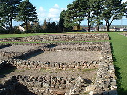
Segontium
Segontium (Old Welsh: Cair Segeint) is a Roman fort on the outskirts of Caernarfon in Gwynedd, North Wales. It was garrisoned by Roman auxiliaries from present-day Belgium and Germany. The fort survived until the end of the Roman occupation of Britain.
Visit Caernarfon plaques
 7
7
plaques
here Caernarfon has 7 physical plaques in tourist plaque schemes for you to explore via Walkfo Caernarfon plaques audio map when visiting. Plaques like National Heritage’s “Blue Plaques” provide visual geo-markers to highlight points-of-interest at the places where they happened – and Walkfo’s AI has researched additional, deeper content when you visit Caernarfon using the app. Experience the history of a location when Walkfo local tourist guide app triggers audio close to each Caernarfon plaque. Explore Plaques & History has a complete list of Hartlepool’s plaques & Hartlepool history plaque map.


 Trying to encourage visitors to Caernarfon?