Welcome to Visit Bwlchgwyn Places
The Walkfo guide to things to do & explore in Bwlchgwyn
 Visit Bwlchgwyn places using Walkfo for free guided tours of the best Bwlchgwyn places to visit. A unique way to experience Bwlchgwyn’s places, Walkfo allows you to explore Bwlchgwyn as you would a museum or art gallery with audio guides.
Visiting Bwlchgwyn Walkfo Preview
Bwlchgwyn is 5 miles (8 km) west of the town of Wrexham and 10 miles (16 km) south-east of Ruthin. In the 2011 Census the population of the village was 855. When you visit Bwlchgwyn, Walkfo brings Bwlchgwyn places to life as you travel by foot, bike, bus or car with a mobile phone & headphones.
Bwlchgwyn Places Overview: History, Culture & Facts about Bwlchgwyn
Visit Bwlchgwyn – Walkfo’s stats for the places to visit
With 18 audio plaques & Bwlchgwyn places for you to explore in the Bwlchgwyn area, Walkfo is the world’s largest heritage & history digital plaque provider. The AI continually learns & refines facts about the best Bwlchgwyn places to visit from travel & tourism authorities (like Wikipedia), converting history into an interactive audio experience.
Bwlchgwyn history
Bwlchgwyn has been inhabited since at least the Bronze Age when a hill fort was built there. It is thought that the original Brythonic inhabitants and later the Romans worked the shallow lead veins of the Eisteddfod. The village prospered in the agricultural and industrial revolutions, benefiting from the rich deposit of silica underground. Local quarries and coal mines provided employment, and the village grew.
Bwlchgwyn etymology
Bwlchgwyn has in the past been translated into English as “White Pass”, perhaps referring to the white limestone cliffs in the area. The translation “pass” does not fit with the Welsh word bwlch and its usual usage in placenames. The gwyn, meaning “white”, is thought to point to the area being the last place in the district where snow settles.
Bwlchgwyn geography / climate
Trefil in Blaenau Gwent claimed to be the highest village in Wales. The village is built on Cefn-y-fedw sandstone, a type of Millstone Grit from the Carboniferous period. Two rivers have their sources near the village.
Why visit Bwlchgwyn with Walkfo Travel Guide App?
 You can visit Bwlchgwyn places with Walkfo Bwlchgwyn to hear history at Bwlchgwyn’s places whilst walking around using the free digital tour app. Walkfo Bwlchgwyn has 18 places to visit in our interactive Bwlchgwyn map, with amazing history, culture & travel facts you can explore the same way you would at a museum or art gallery with information audio headset. With Walkfo, you can travel by foot, bike or bus throughout Bwlchgwyn, being in the moment, without digital distraction or limits to a specific walking route. Our historic audio walks, National Trust interactive audio experiences, digital tour guides for English Heritage locations are available at Bwlchgwyn places, with a AI tour guide to help you get the best from a visit to Bwlchgwyn & the surrounding areas.
“Curated content for millions of locations across the UK, with 18 audio facts unique to Bwlchgwyn places in an interactive Bwlchgwyn map you can explore.”
Walkfo: Visit Bwlchgwyn Places Map
18 tourist, history, culture & geography spots
Bwlchgwyn historic spots | Bwlchgwyn tourist destinations | Bwlchgwyn plaques | Bwlchgwyn geographic features |
| Walkfo Bwlchgwyn tourism map key: places to see & visit like National Trust sites, Blue Plaques, English Heritage locations & top tourist destinations in Bwlchgwyn | |||
Best Bwlchgwyn places to visit
Bwlchgwyn has places to explore by foot, bike or bus. Below are a selection of the varied Bwlchgwyn’s destinations you can visit with additional content available at the Walkfo Bwlchgwyn’s information audio spots:
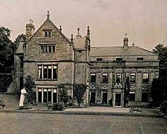 | Brymbo Hall Brymbo Hall is one of Britain’s lost houses. It was the residence of industrialist and ironmaster John “Iron-Mad” Wilkinson. It is reputed to have been partly built to the designs of Inigo Jones. |
 | Wrexham-Rhos transmitting station The Wrexham-Rhos transmitting station is a digital television relay of Moel-y-Parc. It is a free-standing lattice tower structure serving around 85,000 homes. It was constructed to coincide with the 1977 National Eisteddfod. It initially provided S4C and BBC One Wales, later joined by HTV Wales in 1997. |
 | Coedpoeth Coedpoeth is a large village and local government community in Wrexham County Borough, Wales. The built-up area with Minera had a population of 5,723 in the 2011 census. |
Visit Bwlchgwyn plaques
 0
0
plaques
here Bwlchgwyn has 0 physical plaques in tourist plaque schemes for you to explore via Walkfo Bwlchgwyn plaques audio map when visiting. Plaques like National Heritage’s “Blue Plaques” provide visual geo-markers to highlight points-of-interest at the places where they happened – and Walkfo’s AI has researched additional, deeper content when you visit Bwlchgwyn using the app. Experience the history of a location when Walkfo local tourist guide app triggers audio close to each Bwlchgwyn plaque. Currently No Physical Plaques.


 Trying to encourage visitors to Bwlchgwyn?