Welcome to Visit Burneside Places The Walkfo guide to things to do & explore in Burneside
Visit Burneside places using Walkfo for free guided tours of the best Burneside places to visit. A unique way to experience Burneside’s places, Walkfo allows you to explore Burneside as you would a museum or art gallery with audio guides.
Visiting Burneside Walkfo Preview Burneside is a small village in South Lakeland in Cumbria. It is located to the north of Kendal and to the south east of Staveley, on the River Kent. It has about 3,000 inhabitants. By the time of the 2011 Census it had been transformed into an electoral ward only. When you visit Burneside, Walkfo brings Burneside places to life as you travel by foot, bike, bus or car with a mobile phone & headphones.
Burneside Places Overview: History, Culture & Facts about Burneside
Visit Burneside – Walkfo’s stats for the places to visit
With 37 audio plaques & Burneside places for you to explore in the Burneside area, Walkfo is the world’s largest heritage & history digital plaque provider. The AI continually learns & refines facts about the best Burneside places to visit from travel & tourism authorities (like Wikipedia), converting history into an interactive audio experience.
Why visit Burneside with Walkfo Travel Guide App?
You can visit Burneside places with Walkfo Burneside to hear history at Burneside’s places whilst walking around using the free digital tour app. Walkfo Burneside has 37 places to visit in our interactive Burneside map, with amazing history, culture & travel facts you can explore the same way you would at a museum or art gallery with information audio headset. With Walkfo, you can travel by foot, bike or bus throughout Burneside, being in the moment, without digital distraction or limits to a specific walking route. Our historic audio walks, National Trust interactive audio experiences, digital tour guides for English Heritage locations are available at Burneside places, with a AI tour guide to help you get the best from a visit to Burneside & the surrounding areas.
“Curated content for millions of locations across the UK, with 37 audio facts unique to Burneside places in an interactive Burneside map you can explore.”
Walkfo Burneside tourism map key: places to see & visit like National Trust sites, Blue Plaques, English Heritage locations & top tourist destinations in Burneside
Best Burneside places to visit
Burneside has places to explore by foot, bike or bus. Below are a selection of the varied Burneside’s destinations you can visit with additional content available at the Walkfo Burneside’s information audio spots:
County Offices, Kendal The County Offices, formerly Westmorland County Hall, is a municipal building in Stricklandgate, Kendal, Cumbria. The structure is a Grade II listed building. It was the headquarters of Westmorlands County Council from 1939 to 1974.
Smooth Lake District Smooth Lake District is an Independent Local Radio station for the Lakes. It is owned and operated by Global and part of the Smooth network. Smooth Lake district is an independent local radio station.
The Castle Dairy The Castle Dairy is a Grade I listed building in Kendal, Cumbria. The name implies a connection to Kendal Castle and it is possibly the town’s oldest continuously inhabited structure.
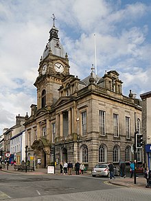
Kendal Town Hall Kendal Town Hall is a municipal building in Kendal, Cumbria. It is a Grade II listed building in the town of Lowther Street, Kendal.
Kendal Parish Church Kendal Parish Church, also known as the Holy Trinity Church, is the Anglican parish church of Kendal, Cumbria, England. It is recorded in the National Heritage List for England as a designated Grade I listed building.
Castle Howe Castle Howe is a motte and bailey castle in the town of Kendal, England. It was built in the 13th century and is located in Kendal.
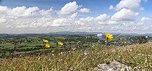
Scout Scar Scout Scar, also called Underbarrow Scar, is a hill in the English Lake District, west of Kendal, Cumbria. It reaches 771 feet (235 m) It is the subject of a chapter of Wainwright’s book The Outlying Fells of Lakeland. The higher summit has a topographic prominence of 109m.
River Gowan, Cumbria The River Gowan is a short river in Cumbria. It runs through the village of Ings before joining the River Kent at Staveley.
Hollin Hall, Cumbria Hollin Hall is a country house in Crook in Cumbria. It is a Grade II listed building. It was built in the 1930s and is located in the Cumbrian town of Crook.
Visit Burneside plaques
26 plaques hereBurneside has 26 physical plaques in tourist plaque schemes for you to explore via Walkfo Burneside plaques audio map when visiting. Plaques like National Heritage’s “Blue Plaques” provide visual geo-markers to highlight points-of-interest at the places where they happened – and Walkfo’s AI has researched additional, deeper content when you visit Burneside using the app. Experience the history of a location when Walkfo local tourist guide app triggers audio close to each Burneside plaque. Explore Plaques & History has a complete list of Hartlepool’s plaques & Hartlepool history plaque map.
Experience Burneside audio walks & tours
Walkfo guides for things to do / places to visit in Burneside allows exploration as you would do an art gallery or museum. Walk close to one of Burneside’s 37 historic places & our digital tour guide will create an audio story for that spot. With headphone connected, you can explore Burneside freely by foot, bike or bus – with your own personal tour guide in your pocket.
Explore Burneside Map App
Our visit Burneside map shows you things-to-do & places you can visit in Burneside & surrounding areas using the Walkfo digital audio tour guide app. Each spot has plaque, building, street or area information on history, culture or tourism.
You can set your Walkfo’s Burneside tourist map to find historic & tourism spots within 1km, 3km & 5km of the Burneside centre, depending on how far you plan to explore whilst you visit Burneside area at LONG:-2.7628, LAT:54.3556.
Walkfo App
Walkfo
Walkfo is free to download & use (for a limited time period), so if you are looking to explore Burneside, go to your App Store to search for “Walkfo” or follow a links below and install on your mobile phone. Walkfo is designed for use with headphones or AirPods, so you can walk & explore whilst learning about the things around you without digital distraction.
Things to do & visit in Burneside / surrounding areas
● Helsfell Hall ● St Thomas’ Church, Kendal ● Kentrigg ● County Offices, Kendal ● Kendal Museum ● Smooth Lake District ● Barony of Kendal ● The Castle Dairy ● Kendal Town Hall ● Quaker Tapestry ● Church of Holy Trinity and St George, Kendal ● St George’s Church, Kendal ● Kendal Parish Church ● Kendal ● Castle Howe ● River Mint ● Bowston ● Strickland Ketel ● Museum of Lakeland Life & Industry ● Abbot Hall Art Gallery ● Burneside ● Burneside Hall ● Kendal Castle ● Cunswick Scar ● Scout Scar ● Skelsmergh ● Cowan Head ● Strickland Roger ● Bonning Gate ● River Gowan, Cumbria
● Hollin Hall, Cumbria ● South Westmorland Rural District ● Whitwell and Selside ● Garnett Bridge ● Skelsmergh and Scalthwaiterigg
Getting to / around Burneside – transport link, station & street map
Getting around in Burneside using public transportation may include road, street, train, underground, bus or tram transport options. Walkfo has identified the following Burneside places with historic / cultural / factual content when you visit:
Local Burneside Public Transport Stations
Burneside Notable Streets & Road Destinations
Kendal railway station
Burneside railway station
Queen Katherine Street drill hall, Kendal
[transportsummary]
Local Burneside historians & Burneside tour guides
Trying to encourage visitors to Burneside? Walkfo has millions audio places already available but Walkfo Creator gives Burneside’s places, attractions & landmarks ability to create their own unique outdoor audio museums & using our simple & easy to use Walkfo Creator. – Creating a new audio experience for your Burneside place is free* and quick (15+ minutes if you prepare text content) to use, with Walkfo Creator doing the hard work of generating AI audio files for geo-spots from the text you provide with a simply click on a map. – The 100 Amazing Burneside Places is just one example of an outdoor museum created using Walkfo Creator (pictured to the left) for people to safely explore during Covid-19 times whilst visiting a city. Our tool is open to tourism organisations, travel destinations & National Trust locations to create their own audio walks to offer free when people visit Burneside destinations. – Walkfo itself is looking to partner with websites offering things-to-do / what’s on events listings to enhance the content of our ‘visit-Burneside’ web pages (for example: www.visitBurneside.com). If you are interested in partnering, please contact us to discuss options.
* Walkfo Creator is free to use for a limited number of audio spots within a map with a license fee applicable when more than 20 audio spots within location walk are created. v1.1336
 Visit Burneside places using Walkfo for free guided tours of the best Burneside places to visit. A unique way to experience Burneside’s places, Walkfo allows you to explore Burneside as you would a museum or art gallery with audio guides.
 You can visit Burneside places with Walkfo Burneside to hear history at Burneside’s places whilst walking around using the free digital tour app. Walkfo Burneside has 37 places to visit in our interactive Burneside map, with amazing history, culture & travel facts you can explore the same way you would at a museum or art gallery with information audio headset. With Walkfo, you can travel by foot, bike or bus throughout Burneside, being in the moment, without digital distraction or limits to a specific walking route. Our historic audio walks, National Trust interactive audio experiences, digital tour guides for English Heritage locations are available at Burneside places, with a AI tour guide to help you get the best from a visit to Burneside & the surrounding areas.


 26
26


 Trying to encourage visitors to Burneside?