Welcome to Visit Brynmawr Places
The Walkfo guide to things to do & explore in Brynmawr
 Visit Brynmawr places using Walkfo for free guided tours of the best Brynmawr places to visit. A unique way to experience Brynmawr’s places, Walkfo allows you to explore Brynmawr as you would a museum or art gallery with audio guides.
Visiting Brynmawr Walkfo Preview
Brynmawr is a market town, community and electoral ward in Blaenau Gwent, Wales. It is situated at 1,250 to 1,500 feet (380 to 460 m) above sea level at the head of the South Wales Valleys. It grew with the development of the coal mining and iron industries in the early 19th century. When you visit Brynmawr, Walkfo brings Brynmawr places to life as you travel by foot, bike, bus or car with a mobile phone & headphones.
Brynmawr Places Overview: History, Culture & Facts about Brynmawr
Visit Brynmawr – Walkfo’s stats for the places to visit
 With 27 audio plaques & Brynmawr places for you to explore in the Brynmawr area, Walkfo is the world’s largest heritage & history digital plaque provider. The AI continually learns & refines facts about the best Brynmawr places to visit from travel & tourism authorities (like Wikipedia), converting history into an interactive audio experience.
Brynmawr history
Gwaun Helygen (meaning ‘marsh of the willows’) sat on a small area of moorland on the border between Monmouthshire and Brecknockshire. The settlement was not home to any heavy industry, and was for the most part a dormitory town. By as early as the 1870s, many resources that were once considered abundant had been exhausted, and the local industry began to decline.
Why visit Brynmawr with Walkfo Travel Guide App?
 You can visit Brynmawr places with Walkfo Brynmawr to hear history at Brynmawr’s places whilst walking around using the free digital tour app. Walkfo Brynmawr has 27 places to visit in our interactive Brynmawr map, with amazing history, culture & travel facts you can explore the same way you would at a museum or art gallery with information audio headset. With Walkfo, you can travel by foot, bike or bus throughout Brynmawr, being in the moment, without digital distraction or limits to a specific walking route. Our historic audio walks, National Trust interactive audio experiences, digital tour guides for English Heritage locations are available at Brynmawr places, with a AI tour guide to help you get the best from a visit to Brynmawr & the surrounding areas.
“Curated content for millions of locations across the UK, with 27 audio facts unique to Brynmawr places in an interactive Brynmawr map you can explore.”
Walkfo: Visit Brynmawr Places Map
27 tourist, history, culture & geography spots
Brynmawr historic spots | Brynmawr tourist destinations | Brynmawr plaques | Brynmawr geographic features |
| Walkfo Brynmawr tourism map key: places to see & visit like National Trust sites, Blue Plaques, English Heritage locations & top tourist destinations in Brynmawr | |||
Best Brynmawr places to visit
Brynmawr has places to explore by foot, bike or bus. Below are a selection of the varied Brynmawr’s destinations you can visit with additional content available at the Walkfo Brynmawr’s information audio spots:
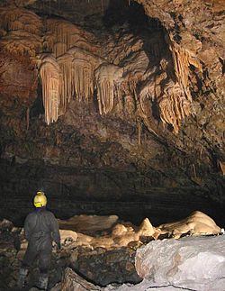
Ogof Craig a Ffynnon
Ogof Craig a Ffynnon (Welsh for “Rock and Fountain Cave”) is a cave in Wales. The cave is located at the base of a quarried rockface in Clydach Gorge. Water flowing out of the cave is a resurgence of water draining off Llangatock Mountain above.

Cwm Clydach National Nature Reserve
Cwm Clydach National Nature Reserve is a 24.8 hectares (61 acres) area of steeply sloping valley-side. It is protected for its ancient semi-natural beech woods, designated by the Nature Conservancy Council.

Mynydd Carn-y-cefn
Mynydd Carn-y-cefn (grid reference SO1808) lies within the unitary area of Blaenau Gwent, formerly Monmouthshire. The broad-topped ridge runs NNW-SSE and achieves a summit height of 550 metres (1,800 ft) at a point crowned by a trig point.

Ebbw Vale Hospital
Ebbw Vale Hospital was a community hospital in Wales. It was managed by the Aneurin Bevan University Health Board. The hospital was known as Ysbyty Ynn Ybbw Vyllyllyll Vale Hospital.

Gwent Archives
Gwent Archives (Welsh: Archifau Gwent) is the local records office and genealogy centre based in Ebbw Vale, South Wales for Monmouthshire. It covers the modern local authority areas of Blaenau, Caerphilly County Borough, Newport and Newport.

Ebbw Vale bus station
Ebbw Vale bus station (Welsh: Gorsaf bws Glyn Ebwy), also known as Inner Bypass, is a bus terminus. It is located in the town centre of Ebbw Vale, South Wales.

Ysbyty Aneurin Bevan
Ysbyty Aneurin Bevan is a community hospital in Ebbw Vale, Wales. It is managed by the Aneuurin Bevan University Health Board.
Brynmawr
Brynmawr is a market town, community and electoral ward in Blaenau Gwent, Wales. It is situated at 1,250 to 1,500 feet (380 to 460 m) above sea level at the head of the South Wales Valleys. It grew with the development of the coal mining and iron industries in the early 19th century.
Visit Brynmawr plaques
 0
0
plaques
here Brynmawr has 0 physical plaques in tourist plaque schemes for you to explore via Walkfo Brynmawr plaques audio map when visiting. Plaques like National Heritage’s “Blue Plaques” provide visual geo-markers to highlight points-of-interest at the places where they happened – and Walkfo’s AI has researched additional, deeper content when you visit Brynmawr using the app. Experience the history of a location when Walkfo local tourist guide app triggers audio close to each Brynmawr plaque. Currently No Physical Plaques.


 Trying to encourage visitors to Brynmawr?