Welcome to Visit Brockweir Places
The Walkfo guide to things to do & explore in Brockweir
 Visit Brockweir places using Walkfo for free guided tours of the best Brockweir places to visit. A unique way to experience Brockweir’s places, Walkfo allows you to explore Brockweir as you would a museum or art gallery with audio guides.
Visiting Brockweir Walkfo Preview
Brockweir is located on the eastern bank of the River Wye in Gloucestershire. The civil parish also includes the separate village of Hewelsfield. A road bridge links it across the river to Monmouthshire, Wales. When you visit Brockweir, Walkfo brings Brockweir places to life as you travel by foot, bike, bus or car with a mobile phone & headphones.
Brockweir Places Overview: History, Culture & Facts about Brockweir
Visit Brockweir – Walkfo’s stats for the places to visit
With 27 audio plaques & Brockweir places for you to explore in the Brockweir area, Walkfo is the world’s largest heritage & history digital plaque provider. The AI continually learns & refines facts about the best Brockweir places to visit from travel & tourism authorities (like Wikipedia), converting history into an interactive audio experience.
Brockweir history
Brockweir is first attested in an annotation on the now lost place-name Pull Brochuail (Welsh pwll ‘pool, lake, pit’ + Welsh personal name Brochfael) in the Book of Llandaff, in a charter dated to c. 620. The weir from which the village gets its name is first documented as a gift to Monmouth Priory from Baderon, Lord of Tintern in c 1120.
Shipbuilding
Trows and barges have been built in Brockweir from at least the eighteenth century. Seagoing vessels, including brigs, schooners and barques, began to be built in the mid-1820s. The largest recorded recorded vessel was the barque Constantine, built in 1847, measuring 506 tons.
Notable residents

Flora Klickmann (1867–1958) wrote several popular books about her experiences of living in the Wye valley near Brockweir. She is buried in the churchyard of the Moravian Church.
Why visit Brockweir with Walkfo Travel Guide App?
 You can visit Brockweir places with Walkfo Brockweir to hear history at Brockweir’s places whilst walking around using the free digital tour app. Walkfo Brockweir has 27 places to visit in our interactive Brockweir map, with amazing history, culture & travel facts you can explore the same way you would at a museum or art gallery with information audio headset. With Walkfo, you can travel by foot, bike or bus throughout Brockweir, being in the moment, without digital distraction or limits to a specific walking route. Our historic audio walks, National Trust interactive audio experiences, digital tour guides for English Heritage locations are available at Brockweir places, with a AI tour guide to help you get the best from a visit to Brockweir & the surrounding areas.
“Curated content for millions of locations across the UK, with 27 audio facts unique to Brockweir places in an interactive Brockweir map you can explore.”
Walkfo: Visit Brockweir Places Map
27 tourist, history, culture & geography spots
Brockweir historic spots | Brockweir tourist destinations | Brockweir plaques | Brockweir geographic features |
| Walkfo Brockweir tourism map key: places to see & visit like National Trust sites, Blue Plaques, English Heritage locations & top tourist destinations in Brockweir | |||
Best Brockweir places to visit
Brockweir has places to explore by foot, bike or bus. Below are a selection of the varied Brockweir’s destinations you can visit with additional content available at the Walkfo Brockweir’s information audio spots:
 | Sylvan House Barn Sylvan House Barn (grid reference SO534023) is a 0.005-hectare (0.012-acre) stone built barn near the village of St Briavels, in the Forest of Dean, Gloucestershire. Site was notified as a biological Site of Special Scientific Interest in 1995. |
 | Church of St Oudoceus, Llandogo The Church of St Oudoceus, Llandogo, Monmouthshire is a parish church built in 1859–1861. The church is dedicated to an early Bishop of Llandaff who retired there and died there in AD 700. Designed by ecclesiastical architect John Pollard Seddon, the church has a notable painted interior. |
 | Wyndcliff The Wyndcliff or Wyndcliffe is a steep limestone cliff rising above the western bank of the River Wye in Monmouthshire, Wales. The cliff rises to 771 feet (235 m) at its summit. The area is traversed by the Wye Valley Walk and is also a popular venue for rock climbing. Access is provided by the A466 road which passes along the valley immediately below the cliff face. |
 | St Anne’s House, Tintern St Anne’s House, Tintern, Monmouthshire, is a house of early medieval origin which includes elements of the gatehouse and chapel of Tintern Abbey. The building was reconstructed in the mid 19th century when it was the home of John Loraine Baldwin, founder of the I Zingari Cricket Club. |
 | Catbrook Catbrook (Welsh: Catffrwd) is a village in Monmouthshire, south east Wales. The population in 2011 was 412. |
 | Poor’s Allotment Poor’s Allotment (grid reference ST560990) is a 28.57-hectare (70.6-acre) biological Site of Special Scientific Interest in Gloucestershire. The site is listed in the ‘Forest of Dean Local Plan Review’ as a Key Wildlife Site (KWS) |
 | Ridley Bottom, Tidenham Ridley Bottom (grid reference ST563985) is a 1.1-hectare (2.7-acre) nature reserve in Gloucestershire. Site is listed in the ‘Forest of Dean Local Plan Review’ as a Key Wildlife Site (KWS) |
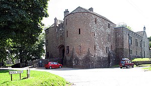 | St Briavels Castle St Briavels Castle was originally built between 1075 and 1129 as a royal administrative centre for the Forest of Dean. During the 13th century the castle became a favourite hunting lodge of King John. The castle was transferred many times between royal favourites in the 14th and 15th centuries and slowly declined in appearance and importance. It became used primarily as a court and as a notorious debtors’ prison. |
Visit Brockweir plaques
 1
1
plaques
here Brockweir has 1 physical plaques in tourist plaque schemes for you to explore via Walkfo Brockweir plaques audio map when visiting. Plaques like National Heritage’s “Blue Plaques” provide visual geo-markers to highlight points-of-interest at the places where they happened – and Walkfo’s AI has researched additional, deeper content when you visit Brockweir using the app. Experience the history of a location when Walkfo local tourist guide app triggers audio close to each Brockweir plaque. Explore Plaques & History has a complete list of Hartlepool’s plaques & Hartlepool history plaque map.


 Trying to encourage visitors to Brockweir?