Welcome to Visit Brockham Places
The Walkfo guide to things to do & explore in Brockham
 Visit Brockham places using Walkfo for free guided tours of the best Brockham places to visit. A unique way to experience Brockham’s places, Walkfo allows you to explore Brockham as you would a museum or art gallery with audio guides.
Visiting Brockham Walkfo Preview
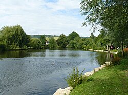
Brockham is a village and civil parish in the Mole Valley district of Surrey. It is approximately 1.5 miles east of Dorking and 4 miles (6.4 km) west of Reigate. At the 2011 census, it had a population of 2,868. When you visit Brockham, Walkfo brings Brockham places to life as you travel by foot, bike, bus or car with a mobile phone & headphones.
Brockham Places Overview: History, Culture & Facts about Brockham
Visit Brockham – Walkfo’s stats for the places to visit
With 38 audio plaques & Brockham places for you to explore in the Brockham area, Walkfo is the world’s largest heritage & history digital plaque provider. The AI continually learns & refines facts about the best Brockham places to visit from travel & tourism authorities (like Wikipedia), converting history into an interactive audio experience.
Brockham landmarks
Betchworth Castle was originally built by Richard FitzGilbert on land granted to him by William the Conqueror soon after the Norman invasion in 1066. Christ Church is relatively recent in origin, having been commissioned in 1847 by Sir Henry Goulburn, who served as both Chancellor of the Exchequer and Home Secretary.
Why visit Brockham with Walkfo Travel Guide App?
 You can visit Brockham places with Walkfo Brockham to hear history at Brockham’s places whilst walking around using the free digital tour app. Walkfo Brockham has 38 places to visit in our interactive Brockham map, with amazing history, culture & travel facts you can explore the same way you would at a museum or art gallery with information audio headset. With Walkfo, you can travel by foot, bike or bus throughout Brockham, being in the moment, without digital distraction or limits to a specific walking route. Our historic audio walks, National Trust interactive audio experiences, digital tour guides for English Heritage locations are available at Brockham places, with a AI tour guide to help you get the best from a visit to Brockham & the surrounding areas.
“Curated content for millions of locations across the UK, with 38 audio facts unique to Brockham places in an interactive Brockham map you can explore.”
Walkfo: Visit Brockham Places Map
38 tourist, history, culture & geography spots
Brockham historic spots | Brockham tourist destinations | Brockham plaques | Brockham geographic features |
| Walkfo Brockham tourism map key: places to see & visit like National Trust sites, Blue Plaques, English Heritage locations & top tourist destinations in Brockham | |||
Best Brockham places to visit
Brockham has places to explore by foot, bike or bus. Below are a selection of the varied Brockham’s destinations you can visit with additional content available at the Walkfo Brockham’s information audio spots:
 | Buckland Windmill Buckland Windmill is a grade II listed smock mill at Buckland, Surrey, England. It is the only surviving wind saw mill in the United Kingdom. |
 | St Joseph’s Church, Dorking St Joseph’s Church is a Roman Catholic Church in Dorking, Surrey. It was founded in 1872 with help from the Duke of Norfolk. It is situated in Falkland Grove in the town. |
 | Dorking Caves The Dorking Caves are a network of manmade tunnels excavated in the soft sandstone of the Upper Greensand deposits beneath Dorkling in Surrey, England. |
 | Deepdene House and Gardens Deepdene was an estate and country house occupying land to the southeast of Dorking, Surrey, England. The remains of the gardens are Grade II* listed with the adjoining Chart Park. |
 | St Martin’s Church, Dorking St Martin’s Church is an Anglican parish church in Dorking, Surrey. It is a Grade II* listed building and surviving parts of the structure date back to the Middle Ages. It was refurbished to the designs of Henry Woodyer. |
 | Vale of Holmesdale Holmesdale is a valley in South-East England that falls between the North Downs and the Greensand Ridge of the Weald. It stretches from Folkestone on the Kent coast, through Ashford, Harrietsham, Maidstone, Redhill, Reigate, Dorking, Gomshall, and Guildford. |
 | Dorking West railway station Dorking West is one of three stations serving the town (Dorking Deepdene) It is 30 miles 42 chains (49.13 km) measured from London Charing Cross via Redhill. The station is unstaffed, and there is no ticket office at the station. |
 | Pipp Brook The Pipp Brook is a left-bank tributary of the River Mole in Surrey. It rises at two main springs north of Leith Hill on the Greensand Ridge. It descends steeply in a northward direction before flowing eastwards along the Vale of Holmesdale. It discharges into the Mole at Pixham, Surrey. |
 | Denbies Wine Estate Denbies Wine Estate, near Dorking, Surrey, has the largest vineyard in England. It has 265 acres under vines, representing more than 10 per cent of the plantings in the whole of the UK. |
 | Reigate Heath Windmill Reigate Heath Windmill is thought to be the only windmill in the world which is a consecrated church. Grade II* listed post mill is used as a chapel. |
Visit Brockham plaques
 7
7
plaques
here Brockham has 7 physical plaques in tourist plaque schemes for you to explore via Walkfo Brockham plaques audio map when visiting. Plaques like National Heritage’s “Blue Plaques” provide visual geo-markers to highlight points-of-interest at the places where they happened – and Walkfo’s AI has researched additional, deeper content when you visit Brockham using the app. Experience the history of a location when Walkfo local tourist guide app triggers audio close to each Brockham plaque. Explore Plaques & History has a complete list of Hartlepool’s plaques & Hartlepool history plaque map.


 Trying to encourage visitors to Brockham?