Welcome to Visit Broad Chalke Places
The Walkfo guide to things to do & explore in Broad Chalke
 Visit Broad Chalke places using Walkfo for free guided tours of the best Broad Chalke places to visit. A unique way to experience Broad Chalke’s places, Walkfo allows you to explore Broad Chalke as you would a museum or art gallery with audio guides.
Visiting Broad Chalke Walkfo Preview
Broad Chalke is a village and civil parish in Wiltshire, England, about 8 miles (13 km) west of Salisbury. The civil parish includes the hamlets of Knapp, Mount Sorrel and Stoke Farthing. When you visit Broad Chalke, Walkfo brings Broad Chalke places to life as you travel by foot, bike, bus or car with a mobile phone & headphones.
Broad Chalke Places Overview: History, Culture & Facts about Broad Chalke
Visit Broad Chalke – Walkfo’s stats for the places to visit
With 12 audio plaques & Broad Chalke places for you to explore in the Broad Chalke area, Walkfo is the world’s largest heritage & history digital plaque provider. The AI continually learns & refines facts about the best Broad Chalke places to visit from travel & tourism authorities (like Wikipedia), converting history into an interactive audio experience.
Broad Chalke history
It is not known when Broad Chalke was first inhabited or what it was called. Fragmentary records from Saxon times indicate that the whole Chalke Valley area was thriving.
9th century
An Anglo-Saxon charter of 826 records the name of the area including Bowerchalke and Broadchalke as Cealcan gemere.
10th century
In 955 the Anglo-Saxon King Eadwig granted the nuns of Wilton Abbey an estate called Chalke which included land in Broad Chalke and Bowerchalke. Another charter in 974 records the name as Cheolca or Cheolcam.
11th century
The Domesday Book in 1086 divided the Chalke Valley into eight manors. Eblesborne (Ebbesbourne Wake), Fifehide (Fifield), Cumbe (Coombe Bissett), Humitone (Homington) Humitone or Humitone. Odestoche (Odstock), Stradford (Stratford Tony and Bishopstone) and Trow (circa Alvediston and Tollard Royal)
12th century
In the 12th century the area was known primarily as the Stowford Hundred. This included the parishes of Berwick St John, Ebbesbourne Wake, Fifield Bavant, Semley, Tollard Royal and ‘Chalke’ A charter of 1165 records the village name as Chalca.
13th century
All Saints’ Church was built during the 13th century. The Curia Regis Rolls of 1207 records the village name as ChelkFeet of Fines. The name Burchelke (Bowerchalke) first appeared in 1225.
14th century
A Saxon charter of 1304 records the village name as Cheolc and Cheolcan. The Feudal Aids of 1316 uses Chawke, while a Saxon Cartulary of 1321 uses Cealce. The Tax lists of 1327, 1332 and 1377 variously record the name as Chalk Magna and Chalke Magna. Brode Chalk was first mentioned in 1380.
15th century
The village is recorded in deeds of 1425 as Brodechalke. The village was recorded in deed deeds of the same name in 1425. It is now known as Brodechke.
16th century
A rectory (now Grade II* listed) was built to the west of the church. Circa 1536 Henry VIII granted Chalke to Sir William Herbert, 1st Earl of Pembroke. Queen Elizabeth I granted Reddish House and farm to William Reddiche in 1560.
17th century
In 1605 the will of Michael Angod spelled the village name as Broadchalk. By 1631 the Earl of Pembroke’s survey used the modern form of Broad Chalke. However, the 1671 Dissenters Meeting House Certificates used Broadcholk.
18th century
The spelling of Broad Chalke continued to vary between 1778 and 1784. In 1778 the will of Elizabeth Fifield spelled it as Broadchalk, whilst the 1784 will of Richard Follit used Broad Chalk.
19th century
By 1846 a cottage served as a National School, and in 1860 a new school and teacher’s house were built opposite the church. Chalke was a comparatively large, disconnected estate that was divided into the two ecclesiastical parishes of Broad Chalk and Bowerchalke in 1880.
20th century
In 1919 the Pembroke family started to sell the individual farms. In 1963 older children began to attend the secondary school at Wilton. Pupil numbers increased after the closure of village schools at Bowerchalke and Bishopstone. In the 1990s the school was extended with a hall and a fourth classroom.
21st century
In 2007 a new school was built on the eastern outskirts of the village. The older school became private housing, and the older school went into private housing.
Broad Chalke geography / climate
Broad Chalke is in the Cranborne Chase and West Wiltshire Downs Area of Outstanding Natural Beauty. The River Chalke flows into the River Ebble at Mount Sorrell in the parish, and the main settlement stands on the banks of the Ebble. The valley road runs from Salisbury in the east to Shaftesbury in the west.
Why visit Broad Chalke with Walkfo Travel Guide App?
 You can visit Broad Chalke places with Walkfo Broad Chalke to hear history at Broad Chalke’s places whilst walking around using the free digital tour app. Walkfo Broad Chalke has 12 places to visit in our interactive Broad Chalke map, with amazing history, culture & travel facts you can explore the same way you would at a museum or art gallery with information audio headset. With Walkfo, you can travel by foot, bike or bus throughout Broad Chalke, being in the moment, without digital distraction or limits to a specific walking route. Our historic audio walks, National Trust interactive audio experiences, digital tour guides for English Heritage locations are available at Broad Chalke places, with a AI tour guide to help you get the best from a visit to Broad Chalke & the surrounding areas.
“Curated content for millions of locations across the UK, with 12 audio facts unique to Broad Chalke places in an interactive Broad Chalke map you can explore.”
Walkfo: Visit Broad Chalke Places Map
12 tourist, history, culture & geography spots
Broad Chalke historic spots | Broad Chalke tourist destinations | Broad Chalke plaques | Broad Chalke geographic features |
| Walkfo Broad Chalke tourism map key: places to see & visit like National Trust sites, Blue Plaques, English Heritage locations & top tourist destinations in Broad Chalke | |||
Best Broad Chalke places to visit
Broad Chalke has places to explore by foot, bike or bus. Below are a selection of the varied Broad Chalke’s destinations you can visit with additional content available at the Walkfo Broad Chalke’s information audio spots:
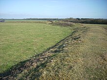 | Chiselbury Chiselbury is the site of an Iron Age univallate hillfort located in Wiltshire. The hillfort is sub-circular in plan, and encloses an area of approximately 10.5 acres (460,000 sq ft) It is defined by an earthen rampart up to 3.6 metres (12 ft) in height and an external ditch. The site is a scheduled national monument no.1020262. |
Visit Broad Chalke plaques
 1
1
plaques
here Broad Chalke has 1 physical plaques in tourist plaque schemes for you to explore via Walkfo Broad Chalke plaques audio map when visiting. Plaques like National Heritage’s “Blue Plaques” provide visual geo-markers to highlight points-of-interest at the places where they happened – and Walkfo’s AI has researched additional, deeper content when you visit Broad Chalke using the app. Experience the history of a location when Walkfo local tourist guide app triggers audio close to each Broad Chalke plaque. Explore Plaques & History has a complete list of Hartlepool’s plaques & Hartlepool history plaque map.


 Trying to encourage visitors to Broad Chalke?