Welcome to Visit Brixton Places
The Walkfo guide to things to do & explore in Brixton
 Visit Brixton places using Walkfo for free guided tours of the best Brixton places to visit. A unique way to experience Brixton’s places, Walkfo allows you to explore Brixton as you would a museum or art gallery with audio guides.
Visiting Brixton Walkfo Preview
When you visit Brixton, Walkfo brings Brixton places to life as you travel by foot, bike, bus or car with a mobile phone & headphones.
Brixton Places Overview: History, Culture & Facts about Brixton
Visit Brixton – Walkfo’s stats for the places to visit
With 421 audio plaques & Brixton places for you to explore in the Brixton area, Walkfo is the world’s largest heritage & history digital plaque provider. The AI continually learns & refines facts about the best Brixton places to visit from travel & tourism authorities (like Wikipedia), converting history into an interactive audio experience.
Brixton history
Toponymy
The name Brixton is thought to originate from Brixistane, meaning the stone of Brixi, a Saxon lord . The location of the stone is unknown but it is believed to be at the top of Brixton Hill, at a road known as Bristow or Brixton Causeway .
Until the mid-19th century
Brixton marks the rise from the marshes in the north of the ancient parish of Lambeth up to the hills of Upper Norwood and Streatham . The main roads were connected through a network of medieval country lanes, such as Acre Lane, Coldharbour Lane, Brixton Water Lane and Lyham Road, formerly Black Lane .
Victorian expansion
London’s sewerage system was built during the mid-19th century . It incorporated flows from the River Effra into its ‘high-level interceptor sewer’, also known as Effra sewer .
Before World War II

Brixton was the shopping capital of south London in the 1920s . It housed the largest shopping centre in south London at the time, as well as cinemas, pubs and a theatre . Today, Brixton Road is the main shopping area, fusing into Brixton Market .
1948: The Windrush generation

In the 1940s and 1950s, many immigrants, particularly from the West Indies and Ireland, settled in Brixton . In the 1950s and 1960s, Brixton was one of the most popular areas in London .
1980s: Riots after police actions and Scarman Report
Brixton was the scene of riots in April 1981 at a time when Brixton underwent deep social and economic problems . The Metropolitan Police began Operation Swamp 81 at the beginning of April, aimed at reducing street crime . Within five days almost 1,000 people were stopped and searched under this law . The riot resulted in almost 279 injuries to police and 45 injuries to members of the public .
1990s: Nail bombing

John Major’s childhood roots in Brixton were used in a campaign poster leading up to the 1992 election . “What does the Conservative Party offer a working class kid from Brixton? They made him Prime Minister.”
2000s: Regeneration vs Gentrification

Brixton has hosted a regular farmers’ market on Station Road, as well as Pop-up restaurants and pop-up shops . Some believe the area has slowly undergone a process of gentrification since the 1990s . Others argue that the area is undergoing exciting regeneration .
Brixton culture & places
Brixton murals
After the riots in 1981 a series of murals were funded by the council . The surviving murals include the Brixton Academy Mural (Stockwell Park Walk) by Stephen Pusey .
Entertainment
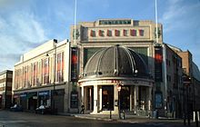
The Ritzy Cinema, Coldharbour Lane, was one of England’s first purpose-built cinemas . The building was designed as the Electric Pavilion in 1910 by E. C. Homer and Lucas .
Media
Brixton is served by two local news blogs – Brixton Blog running since 2010 which also prints a monthly newspaper, and Brixton Buzz running since 2011 .
Why visit Brixton with Walkfo Travel Guide App?
 You can visit Brixton places with Walkfo Brixton to hear history at Brixton’s places whilst walking around using the free digital tour app. Walkfo Brixton has 421 places to visit in our interactive Brixton map, with amazing history, culture & travel facts you can explore the same way you would at a museum or art gallery with information audio headset. With Walkfo, you can travel by foot, bike or bus throughout Brixton, being in the moment, without digital distraction or limits to a specific walking route. Our historic audio walks, National Trust interactive audio experiences, digital tour guides for English Heritage locations are available at Brixton places, with a AI tour guide to help you get the best from a visit to Brixton & the surrounding areas.
“Curated content for millions of locations across the UK, with 421 audio facts unique to Brixton places in an interactive Brixton map you can explore.”
Walkfo: Visit Brixton Places Map
421 tourist, history, culture & geography spots
Brixton historic spots | Brixton tourist destinations | Brixton plaques | Brixton geographic features |
| Walkfo Brixton tourism map key: places to see & visit like National Trust sites, Blue Plaques, English Heritage locations & top tourist destinations in Brixton | |||
Best Brixton places to visit
Brixton has places to explore by foot, bike or bus. Below are a selection of the varied Brixton’s destinations you can visit with additional content available at the Walkfo Brixton’s information audio spots:

Mandela Way T-34 Tank
The Mandela Way T-34 Tank, nicknamed Stompie, is a decommissioned Soviet-built tank . It is now permanently located on the corner of Mandela Way and Page’s Walk in Bermondsey, London .

Miloco Studios
Miloco Studios are a group of recording studios based in London, England . Miloco studios are based in the city of London and London .

Burgess Park
Burgess Park is a public park situated in Walworth the London Borough of Southwark . At 56 hectares (140 acres), it is one of the largest parks in South London .

John Smith House (Southwark)
John Smith House is the former Labour Party headquarters in south London . The party first occupied the building in 1980, vacating its former headquarters at Transport House .

Browning Hall
Browning Hall was a social settlement established in Walworth, London, in 1895 . It was one of a number of such ‘settlements’ arising out of the settlement movement and university extension movement .

Peckham Library
Peckham Library is a library and community building in south-east London . It was designed by Alsop and Störmer, engineered by AKT II and won the Stirling Prize for Architecture in 2000 .

The Institute of Optometry
Institute of Optometry is a centre for optometry in south London . It was established in 1922 as the London Refraction Hospital, London .

Skipton House
Skipton House is a high specification office building in Elephant and Castle, Central London . The building is located in the centre of London’s central London .

Royal Surrey Gardens
Royal Surrey Gardens were pleasure gardens in Newington, Surrey, London in the Victorian period . The gardens occupied about 15 acres (6.1 ha) to the east side of Kennington Park Road, east of The Oval . It was the site of Surrey Zoological Gardens and Surrey Music Hall .

South Bank Technopark
South Bank Technopark at London South Bank University, England, houses the main administration for the university, including the Vice-Chancellor’s Office, under the leadership of Prof. David Phoenix .
Visit Brixton plaques
 118
118
plaques
here Brixton has 118 physical plaques in tourist plaque schemes for you to explore via Walkfo Brixton plaques audio map when visiting. Plaques like National Heritage’s “Blue Plaques” provide visual geo-markers to highlight points-of-interest at the places where they happened – and Walkfo’s AI has researched additional, deeper content when you visit Brixton using the app. Experience the history of a location when Walkfo local tourist guide app triggers audio close to each Brixton plaque. Explore Plaques & History has a complete list of Hartlepool’s plaques & Hartlepool history plaque map.


 Trying to encourage visitors to Brixton?