Welcome to Visit Bridgend Places
The Walkfo guide to things to do & explore in Bridgend
 Visit Bridgend places using Walkfo for free guided tours of the best Bridgend places to visit. A unique way to experience Bridgend’s places, Walkfo allows you to explore Bridgend as you would a museum or art gallery with audio guides.
Visiting Bridgend Walkfo Preview
Bridgend is located 20 miles west of Cardiff and 20 miles east of Swansea . The town is undergoing a redevelopment project, with the town centre mainly pedestrianised . The 2011 census reported that the BridGend Local Authority had a population of 139,200 – up from 128,700 in 2001 . When you visit Bridgend, Walkfo brings Bridgend places to life as you travel by foot, bike, bus or car with a mobile phone & headphones.
Bridgend Places Overview: History, Culture & Facts about Bridgend
Visit Bridgend – Walkfo’s stats for the places to visit
With 54 audio plaques & Bridgend places for you to explore in the Bridgend area, Walkfo is the world’s largest heritage & history digital plaque provider. The AI continually learns & refines facts about the best Bridgend places to visit from travel & tourism authorities (like Wikipedia), converting history into an interactive audio experience.
Bridgend history
Prehistoric and Roman
Several prehistoric burial mounds have been found in the vicinity of Bridgend . The Vale of Glamorgan would have been a natural low-level route west to the Roman fort and harbour at Neath (Nidum) from settlements in the east like Cardiff and Caerleon (Isca)
Norman invasion
Normans looked westwards to create new seats for lords loyal to William the Conqueror . Groups of Norman barons arrived in Wales, and in the south and east created what would later become the Welsh Marches . Newcastle Castle (on Newcastle Hill, overlooking the town centre, 1106) and Ogmore Castle (1116) provided a “defensive triangle” for the area .
Early development
Bridgend developed at a ford on the River Ogmore, which was on the main route between east and west Wales . In the 15th century, a stone bridge was built as a permanent connection between the two sides of the Ogmore . Originally, this bridge had four arches, but in the 18th century a massive flood washed two of them away .
Industrial era
First coal mining operations opened north of Bridgend in the 17th century; the Llynfi Valley was the first to be industrialised . The valleys of the three rivers grew into an important part of the South Wales coalfields .
Second World War
In the Second World War, Bridgend had a prisoner of war (POW) camp and a large munitions factory . At its peak, the arsenal had 40,000 workers, many of them women . The admiralty ceased full-scale production in December 1945 after five years .
After the war
Bridgend stands equidistantly between Swansea to the west and Cardiff to the east . In 1960, the River Ogmore burst its banks and flooded the town centre . The town centre has not been flooded since . The Beeching cuts of the 1960s had the loss of passenger rail links in the Vale of Glamorgan .
New millennium
Some local traders argue that this has damaged trade due to a lack of access by taxis and the disabled . Car parking provision and pricing have also been a concern to retailers with calls for free or reduced-price parking .
Future developments

Construction on a 1500-home sustainable “village” at Parc Derwen near Coity began in 2011 . The scheme was a collaboration between house-builders and public bodies including the National Assembly . Concerns exist from Coity in particular that this development may impact their village’s identity .
Bridgend culture & places
Nightlife
In December 2008, Bridgend Council introduced its first alcohol-free zone, restricting the consumption of alcohol to pubs, clubs, and other licensed premises . CCTV is in operation throughout the town centre, and usually police have a presence of some form .
Music
Those Damn Crows, Bullet for My Valentine and Funeral for a Friend are rock/metal acts from the borough . Bryan Adams played to a 15,000 crowd at Brewery Field stadium in 2006 . The Recreation Centre has hosted acts such as Fall Out Boy and Bring Me the Horizon .
Eisteddfodau
Bridgend County hosted the Urdd Gobaith Cymru National Eisteddfod in 2017 . Bridgends hosted the National Eistsedd fod in 1948 . The county hosted the event in 1948 and 2017 .
Media
Bridgend has its own commercial radio station: 106.3 Bridge FM, and is the location of Internet-based radio station Celtica radio . The main local newspaper is The Glamorgan Gazette, although a free newspaper has increased its circulation in recent times .
Bridgend economy & business
Shopping
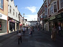
In the town centre the main retail shopping areas are the Rhiw Shopping Centre (containing Bridgend Market), Adare Street, Caroline Street, Derwen Road, Queen Street, Dunraven Place, Market Street and Cheapside . There are out-of-town shopping areas at Waterton, near the A473, on Cowbridge Road .
Why visit Bridgend with Walkfo Travel Guide App?
 You can visit Bridgend places with Walkfo Bridgend to hear history at Bridgend’s places whilst walking around using the free digital tour app. Walkfo Bridgend has 54 places to visit in our interactive Bridgend map, with amazing history, culture & travel facts you can explore the same way you would at a museum or art gallery with information audio headset. With Walkfo, you can travel by foot, bike or bus throughout Bridgend, being in the moment, without digital distraction or limits to a specific walking route. Our historic audio walks, National Trust interactive audio experiences, digital tour guides for English Heritage locations are available at Bridgend places, with a AI tour guide to help you get the best from a visit to Bridgend & the surrounding areas.
“Curated content for millions of locations across the UK, with 54 audio facts unique to Bridgend places in an interactive Bridgend map you can explore.”
Walkfo: Visit Bridgend Places Map
54 tourist, history, culture & geography spots
Bridgend historic spots | Bridgend tourist destinations | Bridgend plaques | Bridgend geographic features |
| Walkfo Bridgend tourism map key: places to see & visit like National Trust sites, Blue Plaques, English Heritage locations & top tourist destinations in Bridgend | |||
Best Bridgend places to visit
Bridgend has places to explore by foot, bike or bus. Below are a selection of the varied Bridgend’s destinations you can visit with additional content available at the Walkfo Bridgend’s information audio spots:

Brackla
Brackla (Welsh: Bracla) is a large housing estate, community and electoral ward in Bridgend County Borough, Wales. At the 2001 census it had a population of 10,113, increasing to 11,749 at the 2011 Census.

Ogwr
The Borough of Ogwr was one of six districts of Mid Glamorgan in Wales, which existed from 1974 to 1996. It was the first district to be named after Ogwr.
Princess of Wales Hospital
Princess of Wales Hospital (Welsh: Ysbyty Tywysoges Cymru) is a district general hospital in Bridgend, Wales. It is managed by Cwm Taf Morgannwg University Health Board.

Newcastle, Bridgend
Newcastle is an area and electoral ward of Bridgend, Wales. The area includes the medieval Newcastle Castle. The ward elects councillors to the Town Council and County Borough Council.
Coity
Coity is a village (and electoral ward) in Bridgend County Borough, south Wales. It is part of the community of Coity Higher and is notable for being home to Coity Castle, one of the best preserved castles in Glamorgan.

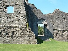
Coity Castle
Norman castle was built by Sir Payn “the Demon” de Turberville, one of the legendary Twelve Knights of Glamorgan. Now in ruins, it stands in the community of Coity Higher near the town of Bridgend.

Ewenny Priory House
Ewenny Priory House is a privately owned Georgian mansion. Originally built in 1545 it was rebuilt in the early 1800s. The house is Grade II* listed.

St Crallo’s Church
St Crallo’s Church is a Grade I listed church in Coychurch Lower, Bridgend County Borough, southern Wales. It is often referred to historically as The Cathedral of the Vale of Glamorgan.

HM Prison Parc
HM Prison Parc is a Category B men’s private prison and Young Offenders Institution in Bridgend, Mid Glamorgan, Wales. Parc Prison is operated by G4S and is the only privately operated prison in Wales.

Parc Hospital
Parc Hospital (Welsh: Ysbyty Parc) was a mental health facility at Bridgend in Wales. It was located at the centre of a mental hospital in Wales.
Visit Bridgend plaques
 0
0
plaques
here Bridgend has 0 physical plaques in tourist plaque schemes for you to explore via Walkfo Bridgend plaques audio map when visiting. Plaques like National Heritage’s “Blue Plaques” provide visual geo-markers to highlight points-of-interest at the places where they happened – and Walkfo’s AI has researched additional, deeper content when you visit Bridgend using the app. Experience the history of a location when Walkfo local tourist guide app triggers audio close to each Bridgend plaque. Currently No Physical Plaques.


 Trying to encourage visitors to Bridgend?