Welcome to Visit Bridge, Kent Places
The Walkfo guide to things to do & explore in Bridge, Kent
 Visit Bridge, Kent places using Walkfo for free guided tours of the best Bridge, Kent places to visit. A unique way to experience Bridge, Kent’s places, Walkfo allows you to explore Bridge, Kent as you would a museum or art gallery with audio guides.
Visiting Bridge, Kent Walkfo Preview
Bridge village is in the Nailbourne valley in a rural setting on the old Roman road, Watling Street, formerly the main road between London and Dover. The village itself is centred 2.5 miles south-east of Canterbury. When you visit Bridge, Kent, Walkfo brings Bridge, Kent places to life as you travel by foot, bike, bus or car with a mobile phone & headphones.
Bridge, Kent Places Overview: History, Culture & Facts about Bridge, Kent
Visit Bridge, Kent – Walkfo’s stats for the places to visit
With 22 audio plaques & Bridge, Kent places for you to explore in the Bridge, Kent area, Walkfo is the world’s largest heritage & history digital plaque provider. The AI continually learns & refines facts about the best Bridge, Kent places to visit from travel & tourism authorities (like Wikipedia), converting history into an interactive audio experience.
Bridge, Kent history
It is likely that the parish took its name from “Bregge”, a bridge which crossed the river Nailbourne, a tributary of the Stour. The parish church is dedicated to Saint Peter.
Bridge, Kent geography / climate
The village is surrounded by a buffer zone, and is almost entirely residential and agricultural. Its layout is a cross between a linear settlement and a clustered settlement.
Why visit Bridge, Kent with Walkfo Travel Guide App?
 You can visit Bridge, Kent places with Walkfo Bridge, Kent to hear history at Bridge, Kent’s places whilst walking around using the free digital tour app. Walkfo Bridge, Kent has 22 places to visit in our interactive Bridge, Kent map, with amazing history, culture & travel facts you can explore the same way you would at a museum or art gallery with information audio headset. With Walkfo, you can travel by foot, bike or bus throughout Bridge, Kent, being in the moment, without digital distraction or limits to a specific walking route. Our historic audio walks, National Trust interactive audio experiences, digital tour guides for English Heritage locations are available at Bridge, Kent places, with a AI tour guide to help you get the best from a visit to Bridge, Kent & the surrounding areas.
“Curated content for millions of locations across the UK, with 22 audio facts unique to Bridge, Kent places in an interactive Bridge, Kent map you can explore.”
Walkfo: Visit Bridge, Kent Places Map
22 tourist, history, culture & geography spots
Bridge, Kent historic spots | Bridge, Kent tourist destinations | Bridge, Kent plaques | Bridge, Kent geographic features |
| Walkfo Bridge, Kent tourism map key: places to see & visit like National Trust sites, Blue Plaques, English Heritage locations & top tourist destinations in Bridge, Kent | |||
Best Bridge, Kent places to visit
Bridge, Kent has places to explore by foot, bike or bus. Below are a selection of the varied Bridge, Kent’s destinations you can visit with additional content available at the Walkfo Bridge, Kent’s information audio spots:
 | Ileden and Oxenden Woods Ileden and Oxenden Woods is an 86.4-hectare (213-acre) biological Site of Special Scientific Interest (SSSI) south-east of Canterbury in Kent. It is in the Kent Downs Area of Outstanding Natural Beauty. |
 | Kent and Canterbury Hospital The Kent and Canterbury Hospital, colloquially known among residents as the K+C, is a community hospital in Canterbury, Kent. It is managed by the East Kent Hospitals University NHS Foundation Trust. |
 | Canterbury Cricket Week Canterbury Cricket Week is the oldest cricket festival week in England. It involves a series of consecutive Kent home matches. It was founded in 1842, although a similar festival week was first held in 1839 by the Beverley Cricket Club. |
 | St Lawrence Ground The St Lawrence Ground is the home ground of Kent County Cricket Club. It is one of the oldest grounds on which first-class cricket is played. The ground was the venue for the first day/night County Championship match in 2011. |
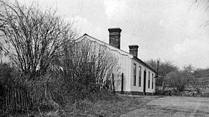 | Bridge railway station Bridge was a station on the Elham Valley Railway. It opened in 1889 and closed in 1940 and freight in 1947. It closed to passengers in 1940. |
 | Bourne Paddock Bourne Paddock was a cricket ground at Bourne Park House, the seat of Sir Horatio Mann. It was a venue for first-class cricket matches from 1766 to 1790. A modern cricket pavilion and a large iron roller used to roll the cricket pitch remain at the site. |
 | Bishopsbourne railway station Bishopsbourne was a station on the Elham Valley Railway. It opened in 1889 and closed to passengers in 1940 and freight in 1947. |
Visit Bridge, Kent plaques
 4
4
plaques
here Bridge, Kent has 4 physical plaques in tourist plaque schemes for you to explore via Walkfo Bridge, Kent plaques audio map when visiting. Plaques like National Heritage’s “Blue Plaques” provide visual geo-markers to highlight points-of-interest at the places where they happened – and Walkfo’s AI has researched additional, deeper content when you visit Bridge, Kent using the app. Experience the history of a location when Walkfo local tourist guide app triggers audio close to each Bridge, Kent plaque. Explore Plaques & History has a complete list of Hartlepool’s plaques & Hartlepool history plaque map.


 Trying to encourage visitors to Bridge, Kent?