Welcome to Visit Bretherton Places
The Walkfo guide to things to do & explore in Bretherton
 Visit Bretherton places using Walkfo for free guided tours of the best Bretherton places to visit. A unique way to experience Bretherton’s places, Walkfo allows you to explore Bretherton as you would a museum or art gallery with audio guides.
Visiting Bretherton Walkfo Preview
Bretherton is a small village and civil parish in the Borough of Chorley, Lancashire. It is situated to the south west of Leyland and east of Tarleton. The population of the civil parish at the 2011 census was 669. When you visit Bretherton, Walkfo brings Bretherton places to life as you travel by foot, bike, bus or car with a mobile phone & headphones.
Bretherton Places Overview: History, Culture & Facts about Bretherton
Visit Bretherton – Walkfo’s stats for the places to visit
With 18 audio plaques & Bretherton places for you to explore in the Bretherton area, Walkfo is the world’s largest heritage & history digital plaque provider. The AI continually learns & refines facts about the best Bretherton places to visit from travel & tourism authorities (like Wikipedia), converting history into an interactive audio experience.
Bretherton history
Toponymy
Bretherton derives from either the Old English brothor and tun or Norse brothir and means “farmstead of the brothers” It was first recorded in documents in 1190.
Manor
Bretherton, was part of the Penwortham fee and assessed as two plough-lands. It was given by the Bussels to Richard le Boteler of Amounderness, who made grants to Cockersand Abbey around 1200 and Lytham Priory. In 1242 the manor was held by six families of Richard Banastre, Walter de Hoole, Richard de Thorp, William de Brexes, Thomas de Gerstan and Simon del Pool. Over time these six parts were consolidated into two moieties held by different branches of the Banastres family. This branch of the family built or rebuilt Bank Hall in the Jacobean style in 1608.
Bretherton landmarks
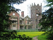
There are several listed buildings in Bretherton including several farmhouses and St John’s Church. The manor house, Bank Hall, a Grade II* Listed Jacobean mansion from 1608 is nearly derelict. It was an unsuccessful contestant on the BBC ‘Restoration’ series in 2003.
Bretherton geography / climate
The township covers 2,292 statute acres of flat low-lying land mostly used for agriculture. The River Lostock forms a village boundary and the River Douglas and River Yarrow join before flowing into the River Ribble to the north. The village is situated towards the centre of the township on slightly rising ground.
Why visit Bretherton with Walkfo Travel Guide App?
 You can visit Bretherton places with Walkfo Bretherton to hear history at Bretherton’s places whilst walking around using the free digital tour app. Walkfo Bretherton has 18 places to visit in our interactive Bretherton map, with amazing history, culture & travel facts you can explore the same way you would at a museum or art gallery with information audio headset. With Walkfo, you can travel by foot, bike or bus throughout Bretherton, being in the moment, without digital distraction or limits to a specific walking route. Our historic audio walks, National Trust interactive audio experiences, digital tour guides for English Heritage locations are available at Bretherton places, with a AI tour guide to help you get the best from a visit to Bretherton & the surrounding areas.
“Curated content for millions of locations across the UK, with 18 audio facts unique to Bretherton places in an interactive Bretherton map you can explore.”
Walkfo: Visit Bretherton Places Map
18 tourist, history, culture & geography spots
Bretherton historic spots | Bretherton tourist destinations | Bretherton plaques | Bretherton geographic features |
| Walkfo Bretherton tourism map key: places to see & visit like National Trust sites, Blue Plaques, English Heritage locations & top tourist destinations in Bretherton | |||
Best Bretherton places to visit
Bretherton has places to explore by foot, bike or bus. Below are a selection of the varied Bretherton’s destinations you can visit with additional content available at the Walkfo Bretherton’s information audio spots:
 | St Mary’s Church, Tarleton St Mary’s Church is a redundant Anglican church on the A59 road in Tarleton, Lancashire. It is described by the Churches Conservation Trust as a “picturesque early Georgian chapel” with “a lovely unspoiled interior” |
 | River Lostock The River Lostock is a river in Lancashire. Its source is at the confluence of Slack Brook and Whave’s Brook. Slack Brook drains an area around Brindle, having its source close to Thorpe Green. The Lostock continues along the Leeds and Liverpool Canal to Lower Copthurst, where it turns westwards. |
 | River Yarrow (Lancashire) The River Yarrow is in Lancashire, with its source at an area called Will Narr at Hordern Stoops, along Spitlers Edge – the Chorley/Blackburn boundary – on the West Pennine Moors. The river feeds the Yarrow Reservoir, which in turn feeds the Anglezarke and Upper and Lower Rivington Reservoirs. Upon leaving the reservoirs, the river passes through an area that was formerly known as Abyssinia. |
Visit Bretherton plaques
 0
0
plaques
here Bretherton has 0 physical plaques in tourist plaque schemes for you to explore via Walkfo Bretherton plaques audio map when visiting. Plaques like National Heritage’s “Blue Plaques” provide visual geo-markers to highlight points-of-interest at the places where they happened – and Walkfo’s AI has researched additional, deeper content when you visit Bretherton using the app. Experience the history of a location when Walkfo local tourist guide app triggers audio close to each Bretherton plaque. Currently No Physical Plaques.


 Trying to encourage visitors to Bretherton?