Welcome to Visit Brackenthwaite, Buttermere Places
The Walkfo guide to things to do & explore in Brackenthwaite, Buttermere
 Visit Brackenthwaite, Buttermere places using Walkfo for free guided tours of the best Brackenthwaite, Buttermere places to visit. A unique way to experience Brackenthwaite, Buttermere’s places, Walkfo allows you to explore Brackenthwaite, Buttermere as you would a museum or art gallery with audio guides.
Visiting Brackenthwaite, Buttermere Walkfo Preview
Brackenthwaite is situated some 6 miles (9.7 km) south of Cockermouth in the county of Cumbria. It lies within the Copeland constituency of the United Kingdom Parliament. When you visit Brackenthwaite, Buttermere, Walkfo brings Brackenthwaite, Buttermere places to life as you travel by foot, bike, bus or car with a mobile phone & headphones.
Brackenthwaite, Buttermere Places Overview: History, Culture & Facts about Brackenthwaite, Buttermere
Visit Brackenthwaite, Buttermere – Walkfo’s stats for the places to visit
With 11 audio plaques & Brackenthwaite, Buttermere places for you to explore in the Brackenthwaite, Buttermere area, Walkfo is the world’s largest heritage & history digital plaque provider. The AI continually learns & refines facts about the best Brackenthwaite, Buttermere places to visit from travel & tourism authorities (like Wikipedia), converting history into an interactive audio experience.
Brackenthwaite, Buttermere etymology
Old Norse brakni ‘bush’ and thveit ‘assart’ (cf. thwaite) like Bregentved (Denmark) and Bracquetuit (Normandy) Bracanethuaite 12th Century.
Why visit Brackenthwaite, Buttermere with Walkfo Travel Guide App?
 You can visit Brackenthwaite, Buttermere places with Walkfo Brackenthwaite, Buttermere to hear history at Brackenthwaite, Buttermere’s places whilst walking around using the free digital tour app. Walkfo Brackenthwaite, Buttermere has 11 places to visit in our interactive Brackenthwaite, Buttermere map, with amazing history, culture & travel facts you can explore the same way you would at a museum or art gallery with information audio headset. With Walkfo, you can travel by foot, bike or bus throughout Brackenthwaite, Buttermere, being in the moment, without digital distraction or limits to a specific walking route. Our historic audio walks, National Trust interactive audio experiences, digital tour guides for English Heritage locations are available at Brackenthwaite, Buttermere places, with a AI tour guide to help you get the best from a visit to Brackenthwaite, Buttermere & the surrounding areas.
“Curated content for millions of locations across the UK, with 11 audio facts unique to Brackenthwaite, Buttermere places in an interactive Brackenthwaite, Buttermere map you can explore.”
Walkfo: Visit Brackenthwaite, Buttermere Places Map
11 tourist, history, culture & geography spots
Brackenthwaite, Buttermere historic spots | Brackenthwaite, Buttermere tourist destinations | Brackenthwaite, Buttermere plaques | Brackenthwaite, Buttermere geographic features |
| Walkfo Brackenthwaite, Buttermere tourism map key: places to see & visit like National Trust sites, Blue Plaques, English Heritage locations & top tourist destinations in Brackenthwaite, Buttermere | |||
Best Brackenthwaite, Buttermere places to visit
Brackenthwaite, Buttermere has places to explore by foot, bike or bus. Below are a selection of the varied Brackenthwaite, Buttermere’s destinations you can visit with additional content available at the Walkfo Brackenthwaite, Buttermere’s information audio spots:
 | Loweswater Loweswater is one of the smaller lakes in the English Lake District. It is situated to the east of the lake and is situated in the village of Lowesworth. |
 | Fellbarrow Fellbarrow is a low hill in the north west of the English Lake District. It is not far from Cockermouth, near to Loweswater, and can be easily climbed from Low Lorton or Thackthwaite. From the summit there are views across the valley to Grasmoor and Whiteside. |
 | Low Fell (Lake District) Low Fell is a fell in the English Lake District. It overlooks the lake of Loweswater to the south and to the north is bordered by its neighbour Fellbarrow. The fell is largely occupied by grassed enclosures. |
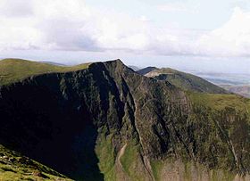
 | Mellbreak Mellbreak is a hill in the Western part of the English Lake District. Despite being surrounded on all sides by higher fells, it stands in isolation. It is surrounded on three sides by a “moat” of deep marshy land, and on the east side by the lake of Crummock Water. |
 | Whiteside (Lake District) Whiteside is a fell in the north-western area of the English Lake District. It stands at the western end of the Grisedale Pike- Hopegill Head ridge overlooking Crummock Water. |
 | Hopegill Head Hopegill Head is a fell in the English Lake District in Cumbria. It is located nine kilometres (5½ miles) west of the town of Keswick. |
 | Grasmoor Grasmoor is the highest peak in a group of hills between Lorton, Braithwaite and Buttermere. It is distinguished by its steep western flank, dropping dramatically to Crummock Water. This face is not suitable for rock climbers as there is little clean rock. |
Visit Brackenthwaite, Buttermere plaques
 0
0
plaques
here Brackenthwaite, Buttermere has 0 physical plaques in tourist plaque schemes for you to explore via Walkfo Brackenthwaite, Buttermere plaques audio map when visiting. Plaques like National Heritage’s “Blue Plaques” provide visual geo-markers to highlight points-of-interest at the places where they happened – and Walkfo’s AI has researched additional, deeper content when you visit Brackenthwaite, Buttermere using the app. Experience the history of a location when Walkfo local tourist guide app triggers audio close to each Brackenthwaite, Buttermere plaque. Currently No Physical Plaques.


 Trying to encourage visitors to Brackenthwaite, Buttermere?