Welcome to Visit Bow, London Places
The Walkfo guide to things to do & explore in Bow, London
![]() Visit Bow, London places using Walkfo for free guided tours of the best Bow, London places to visit. A unique way to experience Bow, London’s places, Walkfo allows you to explore Bow, London as you would a museum or art gallery with audio guides.
Visit Bow, London places using Walkfo for free guided tours of the best Bow, London places to visit. A unique way to experience Bow, London’s places, Walkfo allows you to explore Bow, London as you would a museum or art gallery with audio guides.
Visiting Bow, London Walkfo Preview
Bow is 4.6 miles (7.4 km) east of Charing Cross. It was in the traditional county of Middlesex but became part of the County of London following the passing of the Local Government Act 1888. “Bow” is an abbreviation of the medieval name Stratford-at-Bow. When you visit Bow, London, Walkfo brings Bow, London places to life as you travel by foot, bike, bus or car with a mobile phone & headphones.
Bow, London Places Overview: History, Culture & Facts about Bow, London
Visit Bow, London – Walkfo’s stats for the places to visit
With 728 audio plaques & Bow, London places for you to explore in the Bow, London area, Walkfo is the world’s largest heritage & history digital plaque provider. The AI continually learns & refines facts about the best Bow, London places to visit from travel & tourism authorities (like Wikipedia), converting history into an interactive audio experience.
Bow, London history
Bridges
Stratforde was first recorded as a settlement in 1177, the name derived from its Old English meaning of paved way to a ford. The ‘paved way’ is likely to refer to the presence of a stone causeway across the marshes, which formed a part of the crossing. Matilda, wife of Henry I, reputedly took a tumble at the ford on her way to Barking Abbey, and ordered a bow-shaped, three-arched bridge to be built over the River Lea.
Religious life

In 1311 permission was granted to build St Mary’s Church, Bow as a chapel of ease to allow the residents a local place of worship. The land was granted by Edward III, on the King’s highway, thus beginning a tradition of island church building. Bow was made an Anglican parish of its own in 1719, with the new parish included the Old Ford area, which has also been known as North Bow.
Goose Fair
Fairfield Road commemorates the Green Goose fair, held there on the Thursday after Pentecost. A Green Goose was a young or mid-summer goose, and slang term for a cuckold or a ‘low’ woman.
Bow porcelain
During the 17th century Bow and the Essex bank became a centre for the slaughter and butchery of cattle for the City market. The piggery which used the mash residue produced by the gin mills at Three Mills meant a ready supply of animal bones. Entrepreneurs Thomas Frye and Edward Heylyn developed a means to mix this with clay and create a form of fine porcelain.
Victorian period
In 1888, the match girls’ strike at the Bryant and May match factory in Fairfield Road was a forerunner of the suffragette movement. Emmeline Pankhurst began the Women’s Social and Political Union (WSPU) in 1903 with her daughters Christabel and Sylvia. Sylvia formed a breakaway movement, the East London Federation of Suffragettes, and based at 198 Bow Road, by the church, in a baker’s shop. Bow was the headquarters of the North London Railway, which opened its locomotive and carriage workshops in 1853.
Inter-war years
A new town hall was built in the mid-1930s at the corner of Bow Road and Fairfield Road. It contains the Poplar Assembly Rooms, now no longer used. A memorial to George Lansbury (1859–1940) stands near 39 Bow Road which was his family home until it was destroyed in the Blitz.
Post-war era

Ownership of Bow Road railway station passed from British Rail to the London Transport Executive in 1950. Victoria Park became known for its open air music festivals, often linked with a political cause in the 1970/80s.
Contemporary

In 1986 the Greater London Council transferred responsibility for Victoria Park to the London borough of Tower Hamlets and the London Borough of Hackney. Between 1986 and 1992 the name Bow applied to one of seven neighbourhoods to whom power was devolved from the council. Bow West and Bow East are two wards formed in 2002 that incorporate Old Ford and the eastern end of Globe Town.
Bow, London geography / climate
Bow has not been an administrative unit for nearly 100 years and this makes definitions of the area difficult. The historic Hamlet which became an Ancient Parish, and the E3 postal area are two principle influences on perceptions of the extent of Bow. The former common known as Bow Common lay far to the south of either of these defined areas.
Ancient Parish
Bow was originally a Hamlet of the Ancient Parish of Stepney, in this context Hamlet refers to a district, a sub-division of a parish with delegated responsibilities, rather than a small village. Bow became an independent parish when the pre-existing Hamlet separated from Stepney in 1719. The boundaries of the Hamlet, which later became the parish, are the only formally defined boundaries the area has had.
E3 Postal area
Bow is closely associated with the E3 postcode area, formed in 1917, but post code areas were never intended to define districts. E3 excludes parts of Bow parish area north of the Hertford Union Canal and extends far to the south of Bow Road to include most of Bromley.
Why visit Bow, London with Walkfo Travel Guide App?
![]() You can visit Bow, London places with Walkfo Bow, London to hear history at Bow, London’s places whilst walking around using the free digital tour app. Walkfo Bow, London has 728 places to visit in our interactive Bow, London map, with amazing history, culture & travel facts you can explore the same way you would at a museum or art gallery with information audio headset. With Walkfo, you can travel by foot, bike or bus throughout Bow, London, being in the moment, without digital distraction or limits to a specific walking route. Our historic audio walks, National Trust interactive audio experiences, digital tour guides for English Heritage locations are available at Bow, London places, with a AI tour guide to help you get the best from a visit to Bow, London & the surrounding areas.
You can visit Bow, London places with Walkfo Bow, London to hear history at Bow, London’s places whilst walking around using the free digital tour app. Walkfo Bow, London has 728 places to visit in our interactive Bow, London map, with amazing history, culture & travel facts you can explore the same way you would at a museum or art gallery with information audio headset. With Walkfo, you can travel by foot, bike or bus throughout Bow, London, being in the moment, without digital distraction or limits to a specific walking route. Our historic audio walks, National Trust interactive audio experiences, digital tour guides for English Heritage locations are available at Bow, London places, with a AI tour guide to help you get the best from a visit to Bow, London & the surrounding areas.
“Curated content for millions of locations across the UK, with 728 audio facts unique to Bow, London places in an interactive Bow, London map you can explore.”
Walkfo: Visit Bow, London Places Map
728 tourist, history, culture & geography spots
Bow, London historic spots | Bow, London tourist destinations | Bow, London plaques | Bow, London geographic features |
| Walkfo Bow, London tourism map key: places to see & visit like National Trust sites, Blue Plaques, English Heritage locations & top tourist destinations in Bow, London | |||
Best Bow, London places to visit
Bow, London has places to explore by foot, bike or bus. Below are a selection of the varied Bow, London’s destinations you can visit with additional content available at the Walkfo Bow, London’s information audio spots:

King’s Stairs Gardens
King’s Stairs Gardens is a riverside park in Bermondsey, London . It is bordered to the north by the River Thames and to the south by Jamaica Road (A200)
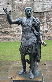
Statue of Trajan, Tower Hill
The statue of Trajan is a bronze sculpture depicting the Roman Emperor Trajan. It is located in front of a section of the London Wall built by Romans, at Tower Hill in London.

East India Arms
The East India Arms is located on Fenchurch Street in the City of London . It is next to the place where the East India Company had its headquarters .

Liberty of Norton Folgate
Norton Folgate was a liberty in Middlesex, England . It was adjacent to the City of London in what would become the East End of London .

Holy Trinity Church, Rotherhithe
Holy Trinity Church is a Church of England parish church in Rotherhithe, south east London, within the diocese of Southwark .

Holy Trinity Priory, Aldgate
The Holy Trinity Priory was founded in 1108 by Queen Matilda of England, wife of King Henry I, near Aldgate in London . The house was founded with clergy from St Botolph’s Priory in Colchester .

Bishopsgate Library
Bishopsgate Library is an independent, charity-funded library . It is located in the Bishops Gate Institute in the City of London .

Tower division
The Tower Division was a liberty in the ancient county of Middlesex, England. It took its name from the military obligations owed to the Constable of the Tower of London. In contemporary terms, the Liberty covered inner East London, the area now administered by the eponymous modern London Borough of Tower Hamlets.

Hackney Wick
Hackney Wick lies 4.2 miles (6.8 km) northeast of Charing Cross. Adjacent areas of the London Borough of Tower Hamlets are sometimes also described as being part of Hackney.

East Village, London
East Village is a housing development in Stratford, East London that was designed and constructed as the Olympic Village of the 2012 Summer Olympics. The area was formerly contaminated waste land and industrial buildings to the north of Stratford town centre.
Visit Bow, London plaques
![]() 136
136
plaques
here Bow, London has 136 physical plaques in tourist plaque schemes for you to explore via Walkfo Bow, London plaques audio map when visiting. Plaques like National Heritage’s “Blue Plaques” provide visual geo-markers to highlight points-of-interest at the places where they happened – and Walkfo’s AI has researched additional, deeper content when you visit Bow, London using the app. Experience the history of a location when Walkfo local tourist guide app triggers audio close to each Bow, London plaque. Explore Plaques & History has a complete list of Hartlepool’s plaques & Hartlepool history plaque map.
