Welcome to Visit Bosporthennis Places The Walkfo guide to things to do & explore in Bosporthennis
Visit Bosporthennis places using Walkfo for free guided tours of the best Bosporthennis places to visit. A unique way to experience Bosporthennis’s places, Walkfo allows you to explore Bosporthennis as you would a museum or art gallery with audio guides.
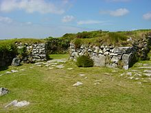
Visiting Bosporthennis Walkfo Preview Bosporthennis is a hamlet south of Treen in the civil parish of Zennor on the Penwith peninsula in west Cornwall. When you visit Bosporthennis, Walkfo brings Bosporthennis places to life as you travel by foot, bike, bus or car with a mobile phone & headphones.
Bosporthennis Places Overview: History, Culture & Facts about Bosporthennis
Visit Bosporthennis – Walkfo’s stats for the places to visit
With 45 audio plaques & Bosporthennis places for you to explore in the Bosporthennis area, Walkfo is the world’s largest heritage & history digital plaque provider. The AI continually learns & refines facts about the best Bosporthennis places to visit from travel & tourism authorities (like Wikipedia), converting history into an interactive audio experience.
Why visit Bosporthennis with Walkfo Travel Guide App?
You can visit Bosporthennis places with Walkfo Bosporthennis to hear history at Bosporthennis’s places whilst walking around using the free digital tour app. Walkfo Bosporthennis has 45 places to visit in our interactive Bosporthennis map, with amazing history, culture & travel facts you can explore the same way you would at a museum or art gallery with information audio headset. With Walkfo, you can travel by foot, bike or bus throughout Bosporthennis, being in the moment, without digital distraction or limits to a specific walking route. Our historic audio walks, National Trust interactive audio experiences, digital tour guides for English Heritage locations are available at Bosporthennis places, with a AI tour guide to help you get the best from a visit to Bosporthennis & the surrounding areas.
“Curated content for millions of locations across the UK, with 45 audio facts unique to Bosporthennis places in an interactive Bosporthennis map you can explore.”
Walkfo Bosporthennis tourism map key: places to see & visit like National Trust sites, Blue Plaques, English Heritage locations & top tourist destinations in Bosporthennis
Best Bosporthennis places to visit
Bosporthennis has places to explore by foot, bike or bus. Below are a selection of the varied Bosporthennis’s destinations you can visit with additional content available at the Walkfo Bosporthennis’s information audio spots:
Madron Well and Madron Well Chapel Madron Well Chapel is the ruin of a 12th- or 14th-century chapel dedicated to St Madern. Clouties, or offerings, can be seen on the path to the chapel, near the holy well.
Lanyon Quoit Lanyon Quoit is a dolmen in Cornwall, England, United Kingdom, 2 miles southeast of Morvah. It collapsed in a storm in 1815 and was re-erected nine years later.
Ding Dong mines The Ding Dong mines lie in an old and extensive mining area situated in the parish of Madron, in Penwith, Cornwall. They are about two miles north east of the St Just to Penzance road. The site has been a UNESCO World Heritage Site since 2006.
Chysauster Ancient Village Chysauster Ancient Village (Cornish: Chisylvester, meaning Sylvester’s house) is a late Iron Age and Romano-British village of courtyard houses. The village included eight to ten houses, each with its own internal courtyard. To the south east is the remains of a fogou, an underground structure of uncertain function.
Zennor Quoit Zennor Quoit is a ruined megalithic burial chamber or dolmen. It dates to 2500–1500 BC. The 12.5-tonne (12,500 kg) roof collapsed some time between 1770 and 1865.
Sperris Quoit Sperris Quoit is a ruined megalithic burial chamber or dolmen. Located on a moor around 365 metres northeast of Zennor Quoit. It is the northernmost quoit in the Penwith peninsula and a Scheduled Monument.
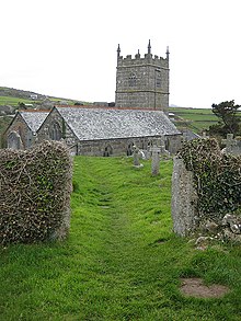
St Senara’s Church, Zennor St Senara’s Church, or The Church of Saint Senara, in Zennor Churchtown, Cornwall, is a Grade I listed building. It is in the Deanery of Penwith, Archdeaconry of Cornwall, and Diocese of Truro.
St Bridget’s Church, Morvah St Bridget’s Church, Morvah is a parish church in the Church of England Diocese of Truro. It was licensed for divine service by the Bishop of Exeter on 22 September 1400. The tower is the only remaining medieval part of the church. The nave and chancel were rebuilt in 1828.
Gurnard’s Head Gurnard’s Head (Cornish: Ynyal, meaning desolate one; grid reference SW432386) is a prominent headland on the north coast of the Penwith peninsula in Cornwall, England, UK.
Pendour Cove Pendour Cove (grid reference SW447389) is a beach in west Cornwall, England, UK. It is about 1 mile northwest of the village of Zennor and immediately to the west of Zennor Head. The name originates from the Cornish ‘pen’ and ‘dour’ (water)
Visit Bosporthennis plaques
0 plaques hereBosporthennis has 0 physical plaques in tourist plaque schemes for you to explore via Walkfo Bosporthennis plaques audio map when visiting. Plaques like National Heritage’s “Blue Plaques” provide visual geo-markers to highlight points-of-interest at the places where they happened – and Walkfo’s AI has researched additional, deeper content when you visit Bosporthennis using the app. Experience the history of a location when Walkfo local tourist guide app triggers audio close to each Bosporthennis plaque. Currently No Physical Plaques.
Experience Bosporthennis audio walks & tours
Walkfo guides for things to do / places to visit in Bosporthennis allows exploration as you would do an art gallery or museum. Walk close to one of Bosporthennis’s 45 historic places & our digital tour guide will create an audio story for that spot. With headphone connected, you can explore Bosporthennis freely by foot, bike or bus – with your own personal tour guide in your pocket.
Explore Bosporthennis Map App
Our visit Bosporthennis map shows you things-to-do & places you can visit in Bosporthennis & surrounding areas using the Walkfo digital audio tour guide app. Each spot has plaque, building, street or area information on history, culture or tourism.
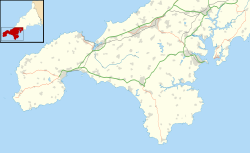
You can set your Walkfo’s Bosporthennis tourist map to find historic & tourism spots within 1km, 3km & 5km of the Bosporthennis centre, depending on how far you plan to explore whilst you visit Bosporthennis area at LONG:-5.5877, LAT:50.1728.
Walkfo App
Walkfo
Walkfo is free to download & use (for a limited time period), so if you are looking to explore Bosporthennis, go to your App Store to search for “Walkfo” or follow a links below and install on your mobile phone. Walkfo is designed for use with headphones or AirPods, so you can walk & explore whilst learning about the things around you without digital distraction.
Things to do & visit in Bosporthennis / surrounding areas
● Madron Well and Madron Well Chapel ● New Mill, Cornwall ● Carfury ● Carfury Standing Stone ● Mulfra ● Bosiliack ● Boskednan ● Lanyon Quoit ● Ding Dong mines ● Bosiliack Barrow ● Chysauster Ancient Village ● Zennor Quoit ● Sperris Quoit ● Wayside Folk Museum ● St Senara’s Church, Zennor ● Morvah ● St Bridget’s Church, Morvah ● Trevowhan ● Great Bosullow ● Treen, Zennor ● Treen Cove ● Boswednack ● Poniou ● Gurnard’s Head ● Porthmeor ● Veor Cove ● Bosporthennis ● Pendour Cove ● Tinner’s Arms ● Zennor
● Zennor Head ● Rosemergy ● Aire Point to Carrick Du SSSI ● Watch Croft ● Mên Scryfa ● Boskednan stone circle ● Bodrifty ● Mulfra Quoit ● Mên-an-Tol ● Little Bosullow ● Lanyon (Madron) ● West Lanyon Quoit ● A. W. Andrews
Getting to / around Bosporthennis – transport link, station & street map
Getting around in Bosporthennis using public transportation may include road, street, train, underground, bus or tram transport options. Walkfo has identified the following Bosporthennis places with historic / cultural / factual content when you visit:
Local Bosporthennis Public Transport Stations
Bosporthennis Notable Streets & Road Destinations
[transportsummary]
Local Bosporthennis historians & Bosporthennis tour guides
Trying to encourage visitors to Bosporthennis? Walkfo has millions audio places already available but Walkfo Creator gives Bosporthennis’s places, attractions & landmarks ability to create their own unique outdoor audio museums & using our simple & easy to use Walkfo Creator. – Creating a new audio experience for your Bosporthennis place is free* and quick (15+ minutes if you prepare text content) to use, with Walkfo Creator doing the hard work of generating AI audio files for geo-spots from the text you provide with a simply click on a map. – The 100 Amazing Bosporthennis Places is just one example of an outdoor museum created using Walkfo Creator (pictured to the left) for people to safely explore during Covid-19 times whilst visiting a city. Our tool is open to tourism organisations, travel destinations & National Trust locations to create their own audio walks to offer free when people visit Bosporthennis destinations. – Walkfo itself is looking to partner with websites offering things-to-do / what’s on events listings to enhance the content of our ‘visit-Bosporthennis’ web pages (for example: www.visitBosporthennis.com). If you are interested in partnering, please contact us to discuss options.
* Walkfo Creator is free to use for a limited number of audio spots within a map with a license fee applicable when more than 20 audio spots within location walk are created. v1.1336
 Visit Bosporthennis places using Walkfo for free guided tours of the best Bosporthennis places to visit. A unique way to experience Bosporthennis’s places, Walkfo allows you to explore Bosporthennis as you would a museum or art gallery with audio guides.
 You can visit Bosporthennis places with Walkfo Bosporthennis to hear history at Bosporthennis’s places whilst walking around using the free digital tour app. Walkfo Bosporthennis has 45 places to visit in our interactive Bosporthennis map, with amazing history, culture & travel facts you can explore the same way you would at a museum or art gallery with information audio headset. With Walkfo, you can travel by foot, bike or bus throughout Bosporthennis, being in the moment, without digital distraction or limits to a specific walking route. Our historic audio walks, National Trust interactive audio experiences, digital tour guides for English Heritage locations are available at Bosporthennis places, with a AI tour guide to help you get the best from a visit to Bosporthennis & the surrounding areas.


 0
0


 Trying to encourage visitors to Bosporthennis?