Welcome to Visit Bolton Places
The Walkfo guide to things to do & explore in Bolton
 Visit Bolton places using Walkfo for free guided tours of the best Bolton places to visit. A unique way to experience Bolton’s places, Walkfo allows you to explore Bolton as you would a museum or art gallery with audio guides.
Visiting Bolton Walkfo Preview
Bolton is a large town in Greater Manchester in North West England, historically and traditionally a part of Lancashire . A former mill town, Bolton has been a production centre for textiles since Flemish weavers settled in the area in the 14th century, introducing a wool and cotton-weaving tradition . The town was a 19th-century boomtown and, at its zenith in 1929, its 216 cotton mills and 26 bleaching and dyeing works made it one of the largest and most productive centres of cotton spinning in the world . When you visit Bolton, Walkfo brings Bolton places to life as you travel by foot, bike, bus or car with a mobile phone & headphones.
Bolton Places Overview: History, Culture & Facts about Bolton
Visit Bolton – Walkfo’s stats for the places to visit
With 80 audio plaques & Bolton places for you to explore in the Bolton area, Walkfo is the world’s largest heritage & history digital plaque provider. The AI continually learns & refines facts about the best Bolton places to visit from travel & tourism authorities (like Wikipedia), converting history into an interactive audio experience.
Bolton history
Toponymy
Bolton is a common Northern English name derived from Old English bothl-tun . The first recorded use of the name, in the form Boelton, dates from 1185 to describe Bolton le Moors . The town’s motto of Supera Moras means “overcome difficulties”
Early history to the Civil War
There is evidence of human existence on the moors around Bolton since the early part of the Bronze Age . Romans built roads from Manchester to Ribchester to the east and a road along what is now the A6 to the west . It is claimed that Agricola built a fort at Blackrod by clearing land above the forest .
Industrial revolution onward
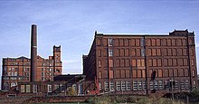
A tradition of cottage spinning and weaving and improvements to spinning technology by local inventors, Richard Arkwright and Samuel Crompton, led to rapid growth of the textile industry in the 19th century. Crompton, whilst living at Hall i’ th’ Wood, invented the spinning mule in 1779. Streams draining the surrounding moorland into the River Croal provided the water necessary for the bleach works that were a feature of this area. Bleaching using chlorine was introduced in the 1790s by the Ainsworths at Halliwell Bleachworks. Bolton and the surrounding villages had more than thirty bleachworks including the Lever Bank Bleach Works in the Irwell Valley. The mule revolutionised cotton spinning by combining the roller drafting of Arkwright’s water frame with the carriage drafting and spindle tip twisting of James Hargreaves’s spinning jenny, producing a high quality yarn. Self-acting mules were used in Bolton mills until the 1960s producing fine yarn. The earliest mills were situated by the streams and river as at Barrow Bridge, but steam power led to the construction of the large multi-storey mills and their chimneys that dominated Bolton’s skyline, some of which survive today. Growth of the textile industry was assisted by the availability of coal in the area. By 1896 John Fletcher had coal mines at Ladyshore in Little Lever; The Earl of Bradford had a coal mine at Great Lever; the Darcy Lever Coal Company had mines at Darcy Lever and there were coal mines at Tonge, Breightmet, Deane and Doffcocker. Some of these pits were close to the Manchester Bolton & Bury Canal providing the owners with markets in Bolton and Manchester. Coal mining declined in the 20th century. Important transport links contributed to the growth of the town and the textile industry; the Manchester Bolton & Bury Canal constructed in 1791, connected the town to Bury and Manchester providing transport for coal and other basic materials. The Bolton and Leigh Railway, the oldest in Lancashire, opened to goods traffic in 1828 and Great Moor Street station opened to passengers in 1831. The railway initially connected Bolton to the Leeds and Liverpool Canal in Leigh, an important link with the port of Liverpool for the import of raw cotton from America, but was extended in 1829 to link up with the Manchester to Liverpool Line. Local firms built locomotives for the railway, in 1830 “Union” was built by Rothwell, Hick and Company and two locomotives, “Salamander” and “Veteran” were built by Crook and Dean. Bolton’s first Mayor, Charles James Darbishire was sympathetic to Chartism and a supporter of the Anti-Corn Law League. In August 1839 Bolton was besieged by Chartist rioters and the Riot Act was read and special constables sworn in. The mayor accompanied soldiers called to rescue special constables at Little Bolton Town Hall, which was besieged by a mob, and the incident ended without bloodshed. Derby Barracks was established in Fletcher Street in the early 1860s. One of two statues prominent on Victoria Square near Bolton Town Hall is that of Samuel Taylor Chadwick (1809 – 3 May 1876) a philanthropist who donated funds to Bolton Hospital to create an ear, nose and throat ward. Built houses for people living in cellars, through Bolton Council fought for better public health including cleaner water, established the Chadwick Orphanage, improved the Bolton Workhouse and funded the towns natural history museum that was the basis of the present Bolton Museum at Le Mans Crescent, the original museum was in a building at Queens Park. The second statue at Victoria Square is in memory of a former Bolton Mayor Sir Benjamin Alfred Dobson (1847–1898) who died in office in 1898, he was a textile machinery manufacturer and chairman of Dobson & Barlow, a significant employer in the town. By 1900 Bolton was Lancashire’s third largest engineering centre after Manchester and Oldham. About 9,000 men were employed in the industry, half of them working for Dobson and Barlow in Kay Street. Another engineering company Hick, Hargreaves & Co based at the Soho Foundry made Lancashire boilers and heavy machinery. Thomas Ryder and Son of Turner Bridge manufactured machine tools for the international motor industry. Wrought iron was produced for more than 100 years at Thomas Walmsley and Sons’ Atlas Forge. By 1911 the textile industry in Bolton employed about 36,000 people. As of 1920, the Bolton Cardroom Union had more than 15,000 members, while the Bolton Weavers’ Association represented 13,500 workers. The last mill to be constructed was Sir John Holden’s Mill in 1927. The cotton industry declined from the 1920s. A brief upturn after the Second World War was not sustained, and the industry had virtually vanished by the end of the 20th century. During the night of 26 September 1916, Bolton was the target for an aerial offensive. L21, a Zeppelin commanded by Oberleutnant Kurt Frankenburg of the Imperial German Navy, dropped twenty-one bombs on the town, five of them on the working class area of Kirk Street, killing thirteen residents and destroying six houses. Further attacks followed on other parts of the town, including three incendiaries dropped close to the Town Hall.
Lord Leverhulme
In 1899, Lord Leverhulme bought Hall i’th’ Wood as a memorial to Samuel Crompton inventor of the spinning mule . Lever restored the dilapidated building and presented it to the town in 1902 . Lever consulted Thomas Mawson, landscape architect and lecturer in Landscape Design at the University of Liverpool, regarding town planning in Bolton .
Bolton landmarks
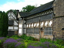
Smithills Hall was where, in 1555, George Marsh was tried for heresy during the Marian Persecutions. The Great Hall was built in the 14th century when William de Radcliffe received the Manor of Smithills from the Hultons, the chapel dates from the 16th century and was extended during the 19th century.
Bolton geography / climate

Bolton lies on the edge of the West Pennine Moors southeast of Rivington Pike (456 m) The early name, Bolton le Moors, described the position of the town amid the low hills. The geological formation around Bolton consists of sandstones of the Carboniferous series and Coal Measures. Climate in the Greater Manchester area is generally similar to the climate of England.
Why visit Bolton with Walkfo Travel Guide App?
 You can visit Bolton places with Walkfo Bolton to hear history at Bolton’s places whilst walking around using the free digital tour app. Walkfo Bolton has 80 places to visit in our interactive Bolton map, with amazing history, culture & travel facts you can explore the same way you would at a museum or art gallery with information audio headset. With Walkfo, you can travel by foot, bike or bus throughout Bolton, being in the moment, without digital distraction or limits to a specific walking route. Our historic audio walks, National Trust interactive audio experiences, digital tour guides for English Heritage locations are available at Bolton places, with a AI tour guide to help you get the best from a visit to Bolton & the surrounding areas.
“Curated content for millions of locations across the UK, with 80 audio facts unique to Bolton places in an interactive Bolton map you can explore.”
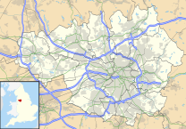
Walkfo: Visit Bolton Places Map
80 tourist, history, culture & geography spots
Bolton historic spots | Bolton tourist destinations | Bolton plaques | Bolton geographic features |
| Walkfo Bolton tourism map key: places to see & visit like National Trust sites, Blue Plaques, English Heritage locations & top tourist destinations in Bolton | |||
Best Bolton places to visit
Bolton has places to explore by foot, bike or bus. Below are a selection of the varied Bolton’s destinations you can visit with additional content available at the Walkfo Bolton’s information audio spots:
 | Seven Acres Country Park, Bolton Seven Acres Country Park is a country park and Local Nature Reserve in Bolton, Greater Manchester. It lies between the areas of Tonge and Breightmet, and is dissected by Bradshaw Brook. The park is more than 300 years old and is depicted on maps dating back to 1764. |
 | Eagley Brook Eagley Brook is a small river of Lancashire and Greater Manchester. It rises at the confluence of several smaller streams at Old Man’s Hill in the West Pennine Moors. The brook feeds Belmont Reservoir and passes the village of Belmont and collects several tributaries. It flows south, through Eagley near Bromley Cross, towards Astley Bridge, after which it joins Astley Brook to form the River Tonge. |
 | Leverhulme Park Leverhulme Park is the largest park in the town of Bolton, Greater Manchester. It was donated to the people of Bolton by the late Lord Lord Leverhulmes. The park is now home to a community centre, an athletics stadium and five-a-side football pitches. |
 | Raikes Park Greyhound Stadium Raikes Park Greyhound Stadium was a greyhound racing track in Bolton, Greater Manchester in north-west England. It is not to be confused with the Westhoughton Greyhound Track, which was another greyhound track in nearby West Houghton. |
 | Holy Trinity Church, Bolton Holy Trinity Church, Bolton is a Grade II listed building. It was a Commissioners’ church, having received a grant towards its construction from the Church Building Commission. |
 | St Patrick’s Church, Bolton St Patrick’s Church is a Roman Catholic Church in Bolton, Greater Manchester. It was built in 1861 and is a Gothic Revival style building. It is situated on the corner of Great Moor Street and Johnson Street. |
 | Derby Barracks, Bolton Derby Barracks is a former military installation in Fletcher Street, Bolton, Greater Manchester. It is located in the centre of the city’s former military base. |
 | Octagon Theatre, Bolton The Octagon Theatre is a producing theatre located in Bolton, Greater Manchester, England. It is located in the city of Bolton and is located on the outskirts of Manchester. |
 | Bolton Town Hall Bolton Town Hall was built between 1866 and 1873 to designs by William Hill of Leeds and George Woodhouse of Bolton. The town hall was extended in the 1930s to the designs of Bradshaw, Gass and Hope. It has been designated a Grade II* listed building by English Heritage. |
 | Bolton Market Hall Bolton Market Hall is a listed building in Bolton, Greater Manchester. The market hall and its integral ground-floor shops on Bridge Street, Corporation Street and Knowsley Street are included in the English Heritage listing. |
Visit Bolton plaques
 12
12
plaques
here Bolton has 12 physical plaques in tourist plaque schemes for you to explore via Walkfo Bolton plaques audio map when visiting. Plaques like National Heritage’s “Blue Plaques” provide visual geo-markers to highlight points-of-interest at the places where they happened – and Walkfo’s AI has researched additional, deeper content when you visit Bolton using the app. Experience the history of a location when Walkfo local tourist guide app triggers audio close to each Bolton plaque. Explore Plaques & History has a complete list of Hartlepool’s plaques & Hartlepool history plaque map.


 Trying to encourage visitors to Bolton?