Welcome to Visit Bloxwich Places
The Walkfo guide to things to do & explore in Bloxwich
 Visit Bloxwich places using Walkfo for free guided tours of the best Bloxwich places to visit. A unique way to experience Bloxwich’s places, Walkfo allows you to explore Bloxwich as you would a museum or art gallery with audio guides.
Visiting Bloxwich Walkfo Preview
Bloxwich is a market town in the Metropolitan Borough of Walsall, West Midlands. It is situated in the north of the borough and forms part of the Staffordshire/West Midlands border. When you visit Bloxwich, Walkfo brings Bloxwich places to life as you travel by foot, bike, bus or car with a mobile phone & headphones.
Bloxwich Places Overview: History, Culture & Facts about Bloxwich
Visit Bloxwich – Walkfo’s stats for the places to visit
With 56 audio plaques & Bloxwich places for you to explore in the Bloxwich area, Walkfo is the world’s largest heritage & history digital plaque provider. The AI continually learns & refines facts about the best Bloxwich places to visit from travel & tourism authorities (like Wikipedia), converting history into an interactive audio experience.
Bloxwich history
Early history
Bloxwich has its origins at least as early as the Anglo-Saxon period. The place name evidence suggests it was a small Mercian settlement named after the family of Bloc. Some 19th-century works suggest at one time it was in the ancient manor of Wednesbury.
18th and 19th centuries
Bloxwich grew rapidly in the 18th century around coal mining, iron smelting and various manufacturing industries. Manufacturing in the area consisted of bridle bits, stirrups, keys, cabinet locks, plane irons, buckle tongues, chains and saddles.
20th and 21st centuries
Bloxwich was heavily developed between the wars for council housing. Most were constructed around Blakenall Heath, as well as Harden and Goscote. The Lower Farm, Beechdale and Mossley estates were also erected as council housing developments. In the 1990s and 2000s, many new housing developments have sprung up.
Why visit Bloxwich with Walkfo Travel Guide App?
 You can visit Bloxwich places with Walkfo Bloxwich to hear history at Bloxwich’s places whilst walking around using the free digital tour app. Walkfo Bloxwich has 56 places to visit in our interactive Bloxwich map, with amazing history, culture & travel facts you can explore the same way you would at a museum or art gallery with information audio headset. With Walkfo, you can travel by foot, bike or bus throughout Bloxwich, being in the moment, without digital distraction or limits to a specific walking route. Our historic audio walks, National Trust interactive audio experiences, digital tour guides for English Heritage locations are available at Bloxwich places, with a AI tour guide to help you get the best from a visit to Bloxwich & the surrounding areas.
“Curated content for millions of locations across the UK, with 56 audio facts unique to Bloxwich places in an interactive Bloxwich map you can explore.”
Walkfo: Visit Bloxwich Places Map
56 tourist, history, culture & geography spots
Bloxwich historic spots | Bloxwich tourist destinations | Bloxwich plaques | Bloxwich geographic features |
| Walkfo Bloxwich tourism map key: places to see & visit like National Trust sites, Blue Plaques, English Heritage locations & top tourist destinations in Bloxwich | |||
Best Bloxwich places to visit
Bloxwich has places to explore by foot, bike or bus. Below are a selection of the varied Bloxwich’s destinations you can visit with additional content available at the Walkfo Bloxwich’s information audio spots:
 | Bentley, West Midlands Bentley is located around Junction 10 of the M6 Motorway. It is also a rural village of houses towards its eastern sides. It shares borders with Willenhall, Beechdale, Ashmore Park, Pleck, Darlaston and Alumwell. |
 | Birchills Power Station Birchills power station and Walsall power station are a series of three coal-fired power stations in the West Midlands. The stations are located in or near, or in, or near Walsalls, England. Birchills is one of the three power stations built in the 1960s and 1970s. |
 | Emmanuel Church, Bentley Emmanuel Church, Bentley is a parish church in the Church of England in Bentley, West Midlands. It is located in the West Midlands and is situated in the East Midlands. |
 | Short Heath, Willenhall Short Heath is a village situated north of the market town of Willenhall, in the Metropolitan Borough of Walsall, West Midlands. The population of the ward is approximately 11,374, according to a mid-2018 ward-level population estimate published by the ONS. The area contains housing developments, several schools, and businesses and shops. |
 | St Andrew’s Church, Walsall St Andrew’s Church is a Free Church of England church in Bentley, Walsall, West Midlands. Three services are held weekly every Sunday at 10am, 11:30am & 6pm. |
 | Darlaston Town (1874) F.C. Darlaston Town (1874) Football Club is based in Walsall, West Midlands. They are currently members of the Midland League Division One and play at the Bentley Sports Pavilion. |
 | Walsall Leather Museum Walsall Leather Museum tells the story of the leather trade in the West Midlands. It charted the town’s rise from a small market town into an international saddle-making centre. The museum was opened in 1988, in a Victorian factory building renovated by council. |
 | The New Art Gallery Walsall The New Art Gallery Walsall is a modern and contemporary art gallery. It was built with £21 million of public funding, including £15.75 million from the UK National Lottery. Admission to the gallery is free. |
| Harden, Walsall Harden is an area to the north of Walsall and borders with Bloxwich, Blakenall Heath, Coalpool, Goscote and Rushall. The whole area was part of the industrial revolution, with mining and metal processing being the main industries. |
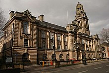 | Walsall Council House Walsall Council House is a Grade II listed building. It is a municipal building in Lichfield Street in the West Midlands, England. |
Visit Bloxwich plaques
 16
16
plaques
here Bloxwich has 16 physical plaques in tourist plaque schemes for you to explore via Walkfo Bloxwich plaques audio map when visiting. Plaques like National Heritage’s “Blue Plaques” provide visual geo-markers to highlight points-of-interest at the places where they happened – and Walkfo’s AI has researched additional, deeper content when you visit Bloxwich using the app. Experience the history of a location when Walkfo local tourist guide app triggers audio close to each Bloxwich plaque. Explore Plaques & History has a complete list of Hartlepool’s plaques & Hartlepool history plaque map.


 Trying to encourage visitors to Bloxwich?