Welcome to Visit Blaengwrach Places
The Walkfo guide to things to do & explore in Blaengwrach
 Visit Blaengwrach places using Walkfo for free guided tours of the best Blaengwrach places to visit. A unique way to experience Blaengwrach’s places, Walkfo allows you to explore Blaengwrach as you would a museum or art gallery with audio guides.
Visiting Blaengwrach Walkfo Preview
Blaengwrach is a community near Glynneath and Resolven in the county borough of Neath Port Talbot, Wales. The principal settlement is Cwmgwrach, a village on the south side of the Neath valley. When you visit Blaengwrach, Walkfo brings Blaengwrach places to life as you travel by foot, bike, bus or car with a mobile phone & headphones.
Blaengwrach Places Overview: History, Culture & Facts about Blaengwrach
Visit Blaengwrach – Walkfo’s stats for the places to visit
With 13 audio plaques & Blaengwrach places for you to explore in the Blaengwrach area, Walkfo is the world’s largest heritage & history digital plaque provider. The AI continually learns & refines facts about the best Blaengwrach places to visit from travel & tourism authorities (like Wikipedia), converting history into an interactive audio experience.
Blaengwrach geography / climate
Mynydd Resolfen (383m/1257 ft) and Craig-y-Llyn (600m/1970 ft) are the highest points of three local hills or mountains in Blaengwrach Community, Glamorgan. The area is home to a nature reserve containing Llyn Fach and a Site of Special Scientific Interest.
Why visit Blaengwrach with Walkfo Travel Guide App?
 You can visit Blaengwrach places with Walkfo Blaengwrach to hear history at Blaengwrach’s places whilst walking around using the free digital tour app. Walkfo Blaengwrach has 13 places to visit in our interactive Blaengwrach map, with amazing history, culture & travel facts you can explore the same way you would at a museum or art gallery with information audio headset. With Walkfo, you can travel by foot, bike or bus throughout Blaengwrach, being in the moment, without digital distraction or limits to a specific walking route. Our historic audio walks, National Trust interactive audio experiences, digital tour guides for English Heritage locations are available at Blaengwrach places, with a AI tour guide to help you get the best from a visit to Blaengwrach & the surrounding areas.
“Curated content for millions of locations across the UK, with 13 audio facts unique to Blaengwrach places in an interactive Blaengwrach map you can explore.”
Walkfo: Visit Blaengwrach Places Map
13 tourist, history, culture & geography spots
Blaengwrach historic spots | Blaengwrach tourist destinations | Blaengwrach plaques | Blaengwrach geographic features |
| Walkfo Blaengwrach tourism map key: places to see & visit like National Trust sites, Blue Plaques, English Heritage locations & top tourist destinations in Blaengwrach | |||
Best Blaengwrach places to visit
Blaengwrach has places to explore by foot, bike or bus. Below are a selection of the varied Blaengwrach’s destinations you can visit with additional content available at the Walkfo Blaengwrach’s information audio spots:

Rheola House
Rheola House is a Grade II* listed country house in Neath valley, South Wales. Designed by John Nash, it was built between 1812 and 1814 for Nash’s cousin, John Edwards. It passed through inheritance to members of the Edwards, Vaughan, and Lee families. In 1939 it was bought by an aluminium company for use as offices.
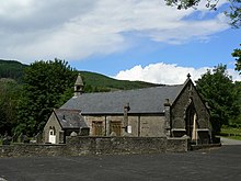
St Cadoc’s Church, Glynneath
St. Cadoc’s Church is a Church in Wales church in Glynneath, Wales. It is located in the grounds of Aberpergwm House for which it was an estate church.

Aberpergwm House
Aberpergwm House is an abandoned and ruinous country house located in Glynneath, Wales. Within the grounds of the house sits the church of St. Cadoc, which is possibly of late medieval origin.

Foel Chwern
Foel Chwern is a Bronze Age burial monument dating to the Bronze Age. It is sited on the edge of a steep scarp slope, with a wide field of view to the north. The long distance footpath Coed Morgannwg Way runs close by the cairn.
Visit Blaengwrach plaques
 0
0
plaques
here Blaengwrach has 0 physical plaques in tourist plaque schemes for you to explore via Walkfo Blaengwrach plaques audio map when visiting. Plaques like National Heritage’s “Blue Plaques” provide visual geo-markers to highlight points-of-interest at the places where they happened – and Walkfo’s AI has researched additional, deeper content when you visit Blaengwrach using the app. Experience the history of a location when Walkfo local tourist guide app triggers audio close to each Blaengwrach plaque. Currently No Physical Plaques.


 Trying to encourage visitors to Blaengwrach?