Welcome to Visit Blackheath, London Places
The Walkfo guide to things to do & explore in Blackheath, London
 Visit Blackheath, London places using Walkfo for free guided tours of the best Blackheath, London places to visit. A unique way to experience Blackheath, London’s places, Walkfo allows you to explore Blackheath, London as you would a museum or art gallery with audio guides.
Visiting Blackheath, London Walkfo Preview
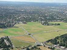
Blackheath is 1 mile north east of Lewisham, 1.5 miles south of Greenwich and 6.4 miles south east of Charing Cross. The area south-west of its station and in its ward is named Lee Park. Its northern neighbourhood of Vanbrugh Park is also known as St John’s Black heath. When you visit Blackheath, London, Walkfo brings Blackheath, London places to life as you travel by foot, bike, bus or car with a mobile phone & headphones.
Blackheath, London Places Overview: History, Culture & Facts about Blackheath, London
Visit Blackheath, London – Walkfo’s stats for the places to visit
With 273 audio plaques & Blackheath, London places for you to explore in the Blackheath, London area, Walkfo is the world’s largest heritage & history digital plaque provider. The AI continually learns & refines facts about the best Blackheath, London places to visit from travel & tourism authorities (like Wikipedia), converting history into an interactive audio experience.
Blackheath, London history
Etymology

Blackheath was recorded in 1166 as Blachehedfeld which means “dark, or black heath field” The name is from Old English spoken words ‘blæc’ and ‘hǣth’ The name gained independent official boundaries by the founding of an Anglican parish in 1854.
Archaeology
A key Celtic trackway (becoming a Roman road and later Watling Street) scaled the rise that is shared with Greenwich Park and a peak 1 mile (1.6 km) east-by-southeast, Shooters Hill. In the west this traversed the mouth of Deptford Creek (the River Ravensbourne) (a corruption or throwback to earlier pronunciation of deep ford) Other finds can be linked to passing trade connected with royal palaces.
Royal setting

The Pagoda is a notably exquisite home, built in 1760 by Sir William Chambers in the style of a traditional Chinese pagoda. It was later leased to the Prince Regent, principally used as a summer home by Caroline of Brunswick. Ranger’s House was the Ranger of Greenwich Park, a royal appointment.
Meeting point
Blackheath was a rallying point for Wat Tyler’s Peasants’ Revolt of 1381 and for Jack Cade’s Kentish rebellion in 1450. Cornish rebels were defeated at the foot of the west slope in the Battle of Deptford Bridge. In 1400 Henry IV of England met with Byzantine Emperor Manuel II Palaiologos who toured western royalty to seek support.
Mineral extraction
The Vanbrugh Pits, known locally as the Dips, are on the north-east of the heath. A former gravel workings site, it has long been reclaimed by nature.
Vanbrugh Park
Vanbrugh Park, a north-east projection of Blackheath with its own church, is named after Sir John Vanbruggh, architect of Blenheim Palace and Castle Howard. The house which was originally built around 1720 remains, remodelled slightly, Vanbuggh Castle. In his estate he had ‘Mince Pie House’ built for his family, which survived until 1911.
Blackheath Park
Blackheath Park occupies almost all of former 0.4-square-mile (1.0 km) Wricklemarsh Manor. Built up in the late 18th and early 19th centuries, it contains large and refined Georgian and Victorian houses.
Other churches

The Church of the Ascension was founded by Susannah Graham late in the 17th century. Its rebuilding was arranged about 1750 by her descendant, the 1st Earl of Dartmouth. Further rebuilding took place in the 1830s leaving parts of the east end from the earlier rebuild.
Ownership and management of the heath
In 1871 the management of the heath passed by statute to the Metropolitan Board of Works. It is held in trust for public benefit under the Metropolitan Commons Act of 1886. It passed to the London County Council in 1889, then to the Greater London Council, then in 1986 to Greenwich and Lewisham.
Blackheath, London geography / climate

Blackheath is one of the largest areas of common land in Greater London. Highlights include the Long Pond (also known as Folly Pond), close to the main entrance of Greenwich Park. Extensive mineral extraction in the 18th and early 19th centuries left large pits in many parts.
Why visit Blackheath, London with Walkfo Travel Guide App?
 You can visit Blackheath, London places with Walkfo Blackheath, London to hear history at Blackheath, London’s places whilst walking around using the free digital tour app. Walkfo Blackheath, London has 273 places to visit in our interactive Blackheath, London map, with amazing history, culture & travel facts you can explore the same way you would at a museum or art gallery with information audio headset. With Walkfo, you can travel by foot, bike or bus throughout Blackheath, London, being in the moment, without digital distraction or limits to a specific walking route. Our historic audio walks, National Trust interactive audio experiences, digital tour guides for English Heritage locations are available at Blackheath, London places, with a AI tour guide to help you get the best from a visit to Blackheath, London & the surrounding areas.
“Curated content for millions of locations across the UK, with 273 audio facts unique to Blackheath, London places in an interactive Blackheath, London map you can explore.”
Walkfo: Visit Blackheath, London Places Map
273 tourist, history, culture & geography spots
Blackheath, London historic spots | Blackheath, London tourist destinations | Blackheath, London plaques | Blackheath, London geographic features |
| Walkfo Blackheath, London tourism map key: places to see & visit like National Trust sites, Blue Plaques, English Heritage locations & top tourist destinations in Blackheath, London | |||
Best Blackheath, London places to visit
Blackheath, London has places to explore by foot, bike or bus. Below are a selection of the varied Blackheath, London’s destinations you can visit with additional content available at the Walkfo Blackheath, London’s information audio spots:
 | Deptford Park Deptford Park is a public park in Deptford south-east London . It is owned by London Borough of Lewisham and owned by the London boroughs . |
 | Evelyn (ward) Evelyn is an electoral ward in the northernmost part of the London Borough of Lewisham . It covers the northern part of Deptford on the south bank of the River Thames . Evelyn borders wards from three other London Boroughs, Greenwich West, Surrey Docks and Southwark . |
 | Aragon Tower Aragon Tower on the Pepys Estate in Deptford, is one of London’s tallest privately owned residential towers at 92 metres with 29 floors . It contains 158 residential apartments ranging from 2 to 3 bedrooms . |
 | Gilbert’s Pit Gilbert’s Pit is a geological Site of Special Scientific Interest in Charlton . It was notified in 1985 and was formerly known as Charlton Sand Pit . It adjoins Maryon Park and is close to Maryon Wilson Park . |
 | Charlton cemetery Charlton cemetery is a cemetery, opened in 1855, covering 15 acres of ground in Charlton, south-east London . Situated in Cemetery Lane to the east of Charlton Park, features two 19th-century chapels and numerous military graves . |
 | Victoria House, Greenwich Victoria House, Greenwich on Shooter’s Hill in Greenwich is the former officers mess’ and living quarters for the Royal Army Medical Corps . It is a “Building of Local Architectural or Historic Interest” |
 | Greenwich Cemetery Greenwich Cemetery is a cemetery in the Royal Borough of Greenwich in southeast London . It is situated on the southwestern slopes of Shooter’s Hill, on the western side of the A205 South Circular, Well Hall Road . |
 | Mycenae House Mycenae House is a community centre housed in a former convent building adjacent to the Georgian villa, Woodlands House, in Greenwich, London . |
 | Severndroog Castle Severndroog Castle is a folly designed by architect Richard Jupp . The first stone was laid on 2 April 1784, with the first stone laid in 1784 . |
 | Ladywell Fields Ladywell Fields is a public park in the London Borough of Lewisham created from three historic fields . It is located near Ladywell railway station at the northern end of the park, and Catford Bridge at the southern end . |
Visit Blackheath, London plaques
 72
72
plaques
here Blackheath, London has 72 physical plaques in tourist plaque schemes for you to explore via Walkfo Blackheath, London plaques audio map when visiting. Plaques like National Heritage’s “Blue Plaques” provide visual geo-markers to highlight points-of-interest at the places where they happened – and Walkfo’s AI has researched additional, deeper content when you visit Blackheath, London using the app. Experience the history of a location when Walkfo local tourist guide app triggers audio close to each Blackheath, London plaque. Explore Plaques & History has a complete list of Hartlepool’s plaques & Hartlepool history plaque map.


 Trying to encourage visitors to Blackheath, London?