Welcome to Visit Birchinlee Places
The Walkfo guide to things to do & explore in Birchinlee
 Visit Birchinlee places using Walkfo for free guided tours of the best Birchinlee places to visit. A unique way to experience Birchinlee’s places, Walkfo allows you to explore Birchinlee as you would a museum or art gallery with audio guides.
Visiting Birchinlee Walkfo Preview
Birchinlee is the site of “Tin Town”, a village built for the workers who constructed the Derwent and Howden Dams. Most of the workers had previously been engaged in the construction, in Wales, of the Elan Valley Reservoirs where the accommodation was very basic. At the site, a “model village” was built; its infrastructure included hospitals, school, canteen (pub), post office, shops, recreation hall, public bath house, police station, railway station, rubbish dump with incinerator. When you visit Birchinlee, Walkfo brings Birchinlee places to life as you travel by foot, bike, bus or car with a mobile phone & headphones.
Birchinlee Places Overview: History, Culture & Facts about Birchinlee
Visit Birchinlee – Walkfo’s stats for the places to visit
With 23 audio plaques & Birchinlee places for you to explore in the Birchinlee area, Walkfo is the world’s largest heritage & history digital plaque provider. The AI continually learns & refines facts about the best Birchinlee places to visit from travel & tourism authorities (like Wikipedia), converting history into an interactive audio experience.
Why visit Birchinlee with Walkfo Travel Guide App?
 You can visit Birchinlee places with Walkfo Birchinlee to hear history at Birchinlee’s places whilst walking around using the free digital tour app. Walkfo Birchinlee has 23 places to visit in our interactive Birchinlee map, with amazing history, culture & travel facts you can explore the same way you would at a museum or art gallery with information audio headset. With Walkfo, you can travel by foot, bike or bus throughout Birchinlee, being in the moment, without digital distraction or limits to a specific walking route. Our historic audio walks, National Trust interactive audio experiences, digital tour guides for English Heritage locations are available at Birchinlee places, with a AI tour guide to help you get the best from a visit to Birchinlee & the surrounding areas.
“Curated content for millions of locations across the UK, with 23 audio facts unique to Birchinlee places in an interactive Birchinlee map you can explore.”
Walkfo: Visit Birchinlee Places Map
23 tourist, history, culture & geography spots
Birchinlee historic spots | Birchinlee tourist destinations | Birchinlee plaques | Birchinlee geographic features |
| Walkfo Birchinlee tourism map key: places to see & visit like National Trust sites, Blue Plaques, English Heritage locations & top tourist destinations in Birchinlee | |||
Best Birchinlee places to visit
Birchinlee has places to explore by foot, bike or bus. Below are a selection of the varied Birchinlee’s destinations you can visit with additional content available at the Walkfo Birchinlee’s information audio spots:

Hope Valley, Derbyshire
The Hope Valley is a rural area centred on the village of Hope, Derbyshire, in the Peak District. The name also applies to the post town that includes the surrounding villages.

St Peter’s Church, Hope
The Domesday Book records that Hope, Derbyshire, had a church. The present parish church dates from the 14th and 15th century with modifications to the chancel dating from 1882. The church has two ancient crosses in its grounds.

St John the Baptist’s Church, Bamford
St John the Baptist church is a C of E church in Bamford in the Hope Valley, Derbyshire, England. It was built in the 1930s and is now a C-of-E church.

Derwent, Derbyshire
Derwent was a village ‘drowned’ in 1944 when the Ladybower Reservoir in Derbyshire was created. The village of Ashopton, Derwent Woodlands church and Derwent Hall also drowned.

Crook Hill
Crook Hill is a small hill in the Peak District National Park in Derbyshire. It is 5 kilometres (3.1 mi) northeast of Castleton.
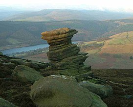
Derwent Edge
Derwent Edge is a Millstone Grit escarpment that lies above the Upper Derwent Valley in the Peak District National Park. An Ordnance Survey column marks the highest point of the Edge at Back Tor (538 metres, 1765 feet) North of Back Tor the edge extends into Howden Edge and enters the county of South Yorkshire.
Visit Birchinlee plaques
 0
0
plaques
here Birchinlee has 0 physical plaques in tourist plaque schemes for you to explore via Walkfo Birchinlee plaques audio map when visiting. Plaques like National Heritage’s “Blue Plaques” provide visual geo-markers to highlight points-of-interest at the places where they happened – and Walkfo’s AI has researched additional, deeper content when you visit Birchinlee using the app. Experience the history of a location when Walkfo local tourist guide app triggers audio close to each Birchinlee plaque. Currently No Physical Plaques.


 Trying to encourage visitors to Birchinlee?