Welcome to Visit Bentworth Places
The Walkfo guide to things to do & explore in Bentworth
 Visit Bentworth places using Walkfo for free guided tours of the best Bentworth places to visit. A unique way to experience Bentworth’s places, Walkfo allows you to explore Bentworth as you would a museum or art gallery with audio guides.
Visiting Bentworth Walkfo Preview
Bentworth is an historic village and large civil parish in the East Hampshire district of Hampshire. The parish covers an area of 3,763 acres (15.23 km) and at its highest point is King’s Hill, 716 feet (218 m) above sea level. According to the 2011 census, Bentworth had a population of 553. The village has two public houses, the Star Inn and the Sun Inn; a primary school; and its own cricket club. When you visit Bentworth, Walkfo brings Bentworth places to life as you travel by foot, bike, bus or car with a mobile phone & headphones.
Bentworth Places Overview: History, Culture & Facts about Bentworth
Visit Bentworth – Walkfo’s stats for the places to visit
With 20 audio plaques & Bentworth places for you to explore in the Bentworth area, Walkfo is the world’s largest heritage & history digital plaque provider. The AI continually learns & refines facts about the best Bentworth places to visit from travel & tourism authorities (like Wikipedia), converting history into an interactive audio experience.
Bentworth history
Prehistory to Roman

A Bronze Age cremation urn was found in 1955 just north of Nancole Copse, approximately 2.5 miles (4.0 km) from St Mary’s Church. Pot sherds and faunal remains from the Iron Age and several coins have been discovered, including a Bronze coin of Valentinian I, discovered in 1956. The Romans built a road between Silchester and the Roman settlement of Vindomis, just east of the present-day town of Alton, which measured 15 Roman miles.
Medieval
Bentworth was not mentioned separately in the 1086 Domesday Survey, although the entry for the surrounding Hundred of Odiham mentions that it had a number of outlying parishes that included Bentworth. The earliest mention of Bentworth village was in the charter of 1111–1116 from Henry I to the Archdiocese of Rouen of “the manor of Bynteworda and the berewica (outlying farm) of Bercham.
Elizabethan to Georgian
The Windsors owned many manors, including Bentworth. Ownership passed in 1610 to Sir James Woolveridge of Odiham and in 1651 to Thomas Turgis. His son, also Thomas, left the manor of Bentworth to his relative William Urry, of Sheat Manor in 1705.
19th century to the Second World War
In 1832 the Fitzherbert family sold the Bentworth Hall estate at an auction in London to Roger Staples Horman Fisher for approximately £6000. In 1848 the estate was sold to Jeremiah Robert Ives. The Ives family later shared ownership with the author George Cecil Ives who lived for a time at the hall with his paternal grandmother.
Second World War

Bentworth Hall was requisitioned for war use and was where a number of organisations were based. During the war nissen huts were built on what is now the Complins housing estate.
Post-war

In 1947 Bentworth Hall estate was bought by Major Herbert Cecil Benyon Berens. Berens family arms included a bear, and when Berens acquired the estate, carvings of bears were put up in various places. In 1982, the Bentworth Conservation Area was established, incorporating many of the local buildings of note.
Bentworth geography / climate

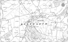
Bentworth village and parish lies on high downland about 3 miles (4.8 km) northwest of the town of Alton and about 8 miles south of Basingstoke. The parish covers an area of 3,763 acres (15.23 km) The names of Windmill Field and Mill Piece indicate the site of one or more ancient mills.
Parish background

Bentworth was the largest parish in the Hundred of Odiham. The parish gained a 95 acres (38 ha) in 1991 by regaining the Home Farm country park.
Villages and hamlets
Burkham is a larger hamlet on the north side of the parish of Bentworth that lies about 2.4 miles (3.9 km) northwest of the village. Other hamlets include Wivelrod to the southeast, Holt End and New Copse to the south, Thedden to the east, Ashley to the west and Tickley to the north.
Why visit Bentworth with Walkfo Travel Guide App?
 You can visit Bentworth places with Walkfo Bentworth to hear history at Bentworth’s places whilst walking around using the free digital tour app. Walkfo Bentworth has 20 places to visit in our interactive Bentworth map, with amazing history, culture & travel facts you can explore the same way you would at a museum or art gallery with information audio headset. With Walkfo, you can travel by foot, bike or bus throughout Bentworth, being in the moment, without digital distraction or limits to a specific walking route. Our historic audio walks, National Trust interactive audio experiences, digital tour guides for English Heritage locations are available at Bentworth places, with a AI tour guide to help you get the best from a visit to Bentworth & the surrounding areas.
“Curated content for millions of locations across the UK, with 20 audio facts unique to Bentworth places in an interactive Bentworth map you can explore.”
Walkfo: Visit Bentworth Places Map
20 tourist, history, culture & geography spots
Bentworth historic spots | Bentworth tourist destinations | Bentworth plaques | Bentworth geographic features |
| Walkfo Bentworth tourism map key: places to see & visit like National Trust sites, Blue Plaques, English Heritage locations & top tourist destinations in Bentworth | |||
Best Bentworth places to visit
Bentworth has places to explore by foot, bike or bus. Below are a selection of the varied Bentworth’s destinations you can visit with additional content available at the Walkfo Bentworth’s information audio spots:
Visit Bentworth plaques
 0
0
plaques
here Bentworth has 0 physical plaques in tourist plaque schemes for you to explore via Walkfo Bentworth plaques audio map when visiting. Plaques like National Heritage’s “Blue Plaques” provide visual geo-markers to highlight points-of-interest at the places where they happened – and Walkfo’s AI has researched additional, deeper content when you visit Bentworth using the app. Experience the history of a location when Walkfo local tourist guide app triggers audio close to each Bentworth plaque. Currently No Physical Plaques.


 Trying to encourage visitors to Bentworth?