Welcome to Visit Bassenthwaite Places
The Walkfo guide to things to do & explore in Bassenthwaite
 Visit Bassenthwaite places using Walkfo for free guided tours of the best Bassenthwaite places to visit. A unique way to experience Bassenthwaite’s places, Walkfo allows you to explore Bassenthwaite as you would a museum or art gallery with audio guides.
Visiting Bassenthwaite Walkfo Preview
Bassenthwaite is at the foot of Skiddaw, one of the highest mountains in England at 3,054 feet. The village contains many elements of the archetypal English village including a green, primary school and a stream that runs through it. When you visit Bassenthwaite, Walkfo brings Bassenthwaite places to life as you travel by foot, bike, bus or car with a mobile phone & headphones.
Bassenthwaite Places Overview: History, Culture & Facts about Bassenthwaite
Visit Bassenthwaite – Walkfo’s stats for the places to visit
 With 17 audio plaques & Bassenthwaite places for you to explore in the Bassenthwaite area, Walkfo is the world’s largest heritage & history digital plaque provider. The AI continually learns & refines facts about the best Bassenthwaite places to visit from travel & tourism authorities (like Wikipedia), converting history into an interactive audio experience.
Bassenthwaite toponymy
The name ‘Bassenthwaite’ is derived from an Old Norse name meaning Bastun’s clearing. The 1st element is usually taken to be the Anglo-French nickname or surname Bastun, originally meaning stick, while the 2nd is the Old Norse þveit meaning clearing.
Why visit Bassenthwaite with Walkfo Travel Guide App?
 You can visit Bassenthwaite places with Walkfo Bassenthwaite to hear history at Bassenthwaite’s places whilst walking around using the free digital tour app. Walkfo Bassenthwaite has 17 places to visit in our interactive Bassenthwaite map, with amazing history, culture & travel facts you can explore the same way you would at a museum or art gallery with information audio headset. With Walkfo, you can travel by foot, bike or bus throughout Bassenthwaite, being in the moment, without digital distraction or limits to a specific walking route. Our historic audio walks, National Trust interactive audio experiences, digital tour guides for English Heritage locations are available at Bassenthwaite places, with a AI tour guide to help you get the best from a visit to Bassenthwaite & the surrounding areas.
“Curated content for millions of locations across the UK, with 17 audio facts unique to Bassenthwaite places in an interactive Bassenthwaite map you can explore.”
Walkfo: Visit Bassenthwaite Places Map
17 tourist, history, culture & geography spots
Bassenthwaite historic spots | Bassenthwaite tourist destinations | Bassenthwaite plaques | Bassenthwaite geographic features |
| Walkfo Bassenthwaite tourism map key: places to see & visit like National Trust sites, Blue Plaques, English Heritage locations & top tourist destinations in Bassenthwaite | |||
Best Bassenthwaite places to visit
Bassenthwaite has places to explore by foot, bike or bus. Below are a selection of the varied Bassenthwaite’s destinations you can visit with additional content available at the Walkfo Bassenthwaite’s information audio spots:
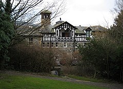 | Bassenfell Manor Bassenfell Manor is a manor house overlooking Bassenthwaite Lake in England’s Lake District. It is used as a Christian residential centre hosting school groups, youth groups, church groups and holidays for individuals and families. |
 | Mirehouse Mirehouse is a 17th-century house to the north of Keswick in Cumbria, at the foot of Dodd, near Bassenthwaite Lake and St Bega’s Church. Although still a family home it and its grounds are open to the public and in 1999 won the award for ‘Best Heritage Property for Families in the UK’ |
 | Bassenthwaite Lake Bassenthwaite Lake is 4 miles (6.4 km) long and 0.75 miles (1 km) wide. It is fed by, and drains into, the River Derwent. The lake lies at the foot of Skiddaw, near the town of Keswick. The A66 runs roughly north–south along the western side of the lake. |
 | Ullock Pike Ullock Pike is a fell situated in northern part of the English Lake District. It is located seven kilometres north west of Keswick and achieves a height of 691 metres (2264 feet) The fell sits on Skiddaw’s south western ridge along with two other fells (Long Side and Carl Side) |
 | Overwater Hall Overwater Hall is a Grade II Listed building in Cumbria. It is a country house near Ireby in the north of the county. |
| Bassenthwaite Bassenthwaite is at the foot of Skiddaw, one of the highest mountains in England at 3,054 feet. The village contains many elements of the archetypal English village including a green, primary school and a stream that runs through it. |
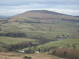 | Binsey Binsey is a hill on the northern edge of the Lake District in Cumbria, England. It provides a good spot to look out at the Northern and North Western Fells and the Solway Firth. Snaefell on the Isle of Man is also visible on a clear day. |
Visit Bassenthwaite plaques
 0
0
plaques
here Bassenthwaite has 0 physical plaques in tourist plaque schemes for you to explore via Walkfo Bassenthwaite plaques audio map when visiting. Plaques like National Heritage’s “Blue Plaques” provide visual geo-markers to highlight points-of-interest at the places where they happened – and Walkfo’s AI has researched additional, deeper content when you visit Bassenthwaite using the app. Experience the history of a location when Walkfo local tourist guide app triggers audio close to each Bassenthwaite plaque. Currently No Physical Plaques.


 Trying to encourage visitors to Bassenthwaite?