Welcome to Visit Basingstoke Places
The Walkfo guide to things to do & explore in Basingstoke
 Visit Basingstoke places using Walkfo for free guided tours of the best Basingstoke places to visit. A unique way to experience Basingstoke’s places, Walkfo allows you to explore Basingstoke as you would a museum or art gallery with audio guides.
Visiting Basingstoke Walkfo Preview
Basingstoke is the largest town in the county of Hampshire. It is located 30 miles (48 km) northeast of Southampton, 48 miles (77 km) southwest of London, 27 miles (43 km) west of Guildford, 22 miles (35 km) south of Reading and 20 miles northeast of Winchester. According to the 2016 population estimate the town had a population of 113,776. It was developed rapidly after the Second World War to accommodate part of the London ‘overspill’ as perceived under the Greater London Plan. When you visit Basingstoke, Walkfo brings Basingstoke places to life as you travel by foot, bike, bus or car with a mobile phone & headphones.
Basingstoke Places Overview: History, Culture & Facts about Basingstoke
Visit Basingstoke – Walkfo’s stats for the places to visit
With 39 audio plaques & Basingstoke places for you to explore in the Basingstoke area, Walkfo is the world’s largest heritage & history digital plaque provider. The AI continually learns & refines facts about the best Basingstoke places to visit from travel & tourism authorities (like Wikipedia), converting history into an interactive audio experience.
Basingstoke history
Early settlements
A Neolithic campsite of around 3000 BC beside a spring on the west of the town is the earliest known human settlement here. The Willis Museum has flint implements and axes from nearby fields that date back to Palæolithic times. The first recorded historical event in the area was the defeat of King Æthelred of Wessex by the Danes in 871.
Market town

Basingstoke is recorded as a weekly market site in the Domesday Book, in 1086, and has held a regular Wednesday market since 1214. During the Civil War, and the siege of Basing House between 1643 and 1645, the town played host to large numbers of Parliamentarians. St. Michael’s Church was damaged whilst being used as an explosive store and lead was stripped from the roof of the Chapel of the Holy Ghost.
Victorian history
Thomas Burberry and Alfred Milward opened their first shops in Basingstoke in 1856. Burberry became famous after he invented Gabardine. Milward founded the Milwards chain of shoe shops, which could be found on almost every high street until the 1980s. The town was described as ‘Barbarous’ by one London newspaper in 1882.
Recent history
A stick of German bombs did fall in the Church Square area on 16 August 1940. The same day bombs destroyed part of a row of houses in Burgess Road. Overall, 13 civilian lives were lost from enemy action during the war in the town. After the war, the town had a population of 25,000.
Basingstoke etymology
The name Basingstoke (A.D 990; Embasinga stocæ, Domesday; Basingestoches) is believed to have been derived from the town’s position as the outlying, western settlement of Basa’s people. Old Basing is thought to have the same etymology, and was the original Anglo-Saxon settlement of the people – Basingas – led by a tribal chief.
Basingstoke geography / climate
Basingstoke is a major interchange between Reading, Newbury, Andover, Winchester, and Alton. Situated in a valley through the Hampshire Downs at an average elevation of 88 metres (289 ft) The area had been something of an interchange even in ancient times.
Physical geography and geology
Basingstoke is situated on a bed of cretaceous upper chalk with small areas of clayey and loamy soil, inset with combined clay and flint patches. The unparished area includes Worting which was previously a separate village and parish, extending beyond Roman Road and Old Kempshott Lane.
Divisions and suburbs
Basingstoke’s expansion has absorbed much surrounding farmland and scattered housing. Many of these new estates are designed as almost self-contained communities. The M3 acts as a buffer zone to the south of the town, and the South West Main Line constrains the western expansion.
Demography
The population of Basingstoke increased from around 2,500 in 1801 to over 52,000 in 1971. The borough was merged with other local districts in 1974 to form the borough of Basesstoke and Deane. Census data from that point covers the whole borough.
Why visit Basingstoke with Walkfo Travel Guide App?
 You can visit Basingstoke places with Walkfo Basingstoke to hear history at Basingstoke’s places whilst walking around using the free digital tour app. Walkfo Basingstoke has 39 places to visit in our interactive Basingstoke map, with amazing history, culture & travel facts you can explore the same way you would at a museum or art gallery with information audio headset. With Walkfo, you can travel by foot, bike or bus throughout Basingstoke, being in the moment, without digital distraction or limits to a specific walking route. Our historic audio walks, National Trust interactive audio experiences, digital tour guides for English Heritage locations are available at Basingstoke places, with a AI tour guide to help you get the best from a visit to Basingstoke & the surrounding areas.
“Curated content for millions of locations across the UK, with 39 audio facts unique to Basingstoke places in an interactive Basingstoke map you can explore.”
Walkfo: Visit Basingstoke Places Map
39 tourist, history, culture & geography spots
Basingstoke historic spots | Basingstoke tourist destinations | Basingstoke plaques | Basingstoke geographic features |
| Walkfo Basingstoke tourism map key: places to see & visit like National Trust sites, Blue Plaques, English Heritage locations & top tourist destinations in Basingstoke | |||
Best Basingstoke places to visit
Basingstoke has places to explore by foot, bike or bus. Below are a selection of the varied Basingstoke’s destinations you can visit with additional content available at the Walkfo Basingstoke’s information audio spots:
 | Eastrop Park Eastrop Park is a public park located in the east of Basingstoke, Hampshire. The park features a large boating lake, a miniature golf course, a café and walking trails. The River Loddon flows through the park, feeding into a balancing pond. |
 | Willis Museum Willis Museum is a local history museum in the Market Place, Basingstoke, Hampshire, England. The building, which was the headquarters of the Borough Council, is a Grade II listed building. |
 | Planet Ice Silverdome Arena The Planet Ice Silverdome Arena is a 2,000-seat multi-purpose arena in Basingstoke, England. It was built in 1988 and has an Olympic sized 60 x 30 metre ice rink. It is one of several ice skating arenas in the UK operated by the Planet Ice company. |
 | May’s Bounty May’s Bounty is a cricket ground situated along Bounty Road in Basingstoke, Hampshire. The Bounty was used intermittently by Hampshire County Cricket Club in the early 20th-century. The ground has a capacity for major matches of 2,500, while its end names are called the Town End and the Castlefield End to the south. |
 | Hackwood Park Hackwood Park is a large country estate that primarily consists of an early 18th-century ornamental woodland and formal lawn garden. The 260-acre (110 ha) grounds contain 23 separately listed structures including a teahouse pavilion, an ornamental bridge, statue of George I of Great Britain, three dispersed stone tōrōs, five urns and two fountains. Sheep and deer are tended to on grounds behind a variously arc-shaped and straight ha-ha wall. |
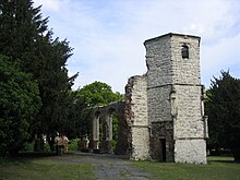
 | St. Michael’s Church, Basingstoke St. Michael’s Church is a notable Anglican parish church in Basingstoke, Hampshire. It is located in the lower part of the town, near its centre, towards its northern end of Church Street. |
Visit Basingstoke plaques
 8
8
plaques
here Basingstoke has 8 physical plaques in tourist plaque schemes for you to explore via Walkfo Basingstoke plaques audio map when visiting. Plaques like National Heritage’s “Blue Plaques” provide visual geo-markers to highlight points-of-interest at the places where they happened – and Walkfo’s AI has researched additional, deeper content when you visit Basingstoke using the app. Experience the history of a location when Walkfo local tourist guide app triggers audio close to each Basingstoke plaque. Explore Plaques & History has a complete list of Hartlepool’s plaques & Hartlepool history plaque map.


 Trying to encourage visitors to Basingstoke?