Welcome to Visit Arden, Glasgow Places
The Walkfo guide to things to do & explore in Arden, Glasgow
 Visit Arden, Glasgow places using Walkfo for free guided tours of the best Arden, Glasgow places to visit. A unique way to experience Arden, Glasgow’s places, Walkfo allows you to explore Arden, Glasgow as you would a museum or art gallery with audio guides.
Visiting Arden, Glasgow Walkfo Preview
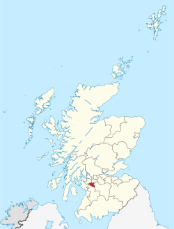
Arden is a medium-sized housing estate on the south-western edge of Glasgow. The M77 motorway runs directly to the west of the neighbourhood, with Junction 3 serving the area. The residential area of Carnwadric is to the north-east of Arden, and the Jenny Lind part of Deaconsbank to the south. When you visit Arden, Glasgow, Walkfo brings Arden, Glasgow places to life as you travel by foot, bike, bus or car with a mobile phone & headphones.
Arden, Glasgow Places Overview: History, Culture & Facts about Arden, Glasgow
Visit Arden, Glasgow – Walkfo’s stats for the places to visit
With 72 audio plaques & Arden, Glasgow places for you to explore in the Arden, Glasgow area, Walkfo is the world’s largest heritage & history digital plaque provider. The AI continually learns & refines facts about the best Arden, Glasgow places to visit from travel & tourism authorities (like Wikipedia), converting history into an interactive audio experience.
Arden, Glasgow history
Arden is near Thornliebank, a village formed on the river to manufacture cloth and a specialized printing of cloth known as beetling. Historically, Arden was a farm and formed part of Sir John Maxwell’s land, one of approximately seven adjoining holdings which were situated on ancient Stewart land, originally granted to Walter Stewart, 6th High Steward of Scotland by Robert the Bruce.
Why visit Arden, Glasgow with Walkfo Travel Guide App?
 You can visit Arden, Glasgow places with Walkfo Arden, Glasgow to hear history at Arden, Glasgow’s places whilst walking around using the free digital tour app. Walkfo Arden, Glasgow has 72 places to visit in our interactive Arden, Glasgow map, with amazing history, culture & travel facts you can explore the same way you would at a museum or art gallery with information audio headset. With Walkfo, you can travel by foot, bike or bus throughout Arden, Glasgow, being in the moment, without digital distraction or limits to a specific walking route. Our historic audio walks, National Trust interactive audio experiences, digital tour guides for English Heritage locations are available at Arden, Glasgow places, with a AI tour guide to help you get the best from a visit to Arden, Glasgow & the surrounding areas.
“Curated content for millions of locations across the UK, with 72 audio facts unique to Arden, Glasgow places in an interactive Arden, Glasgow map you can explore.”
Walkfo: Visit Arden, Glasgow Places Map
72 tourist, history, culture & geography spots
Arden, Glasgow historic spots | Arden, Glasgow tourist destinations | Arden, Glasgow plaques | Arden, Glasgow geographic features |
| Walkfo Arden, Glasgow tourism map key: places to see & visit like National Trust sites, Blue Plaques, English Heritage locations & top tourist destinations in Arden, Glasgow | |||
Best Arden, Glasgow places to visit
Arden, Glasgow has places to explore by foot, bike or bus. Below are a selection of the varied Arden, Glasgow’s destinations you can visit with additional content available at the Walkfo Arden, Glasgow’s information audio spots:
 | Mansewood Mansewood (Scots: Mansewid) is a residential district in the Scottish city of Glasgow. It is situated south of the River Clyde and is surrounded by the districts of Eastwood, Hillpark, Pollokshaws in Glasgow and Thornliebank and Giffnock. |
 | East Renfrewshire East Renfrewshire is one of 32 council areas of Scotland . Until 1975, it formed part of the county of Renfreyshire for local government purposes . It was formed in 1996 as a successor to the Eastwood district, with the Levern Valley being annexed . |
 | Muirend Muirend is situated about 4 miles (6.5 km) south of Glasgow city centre. The G44 postcode was rated as the most desirable area of Scotland to live in. Neighbouring areas include Cathcart, Merrylee and Newlands. |
| Nitshill Nitshill (Scottish Gaelic: Cnoc nan Cnòthan) is a district on the south side of Glasgow. It is bordered by Darnley to the east, Crookston and Roughmussel to the north-west. The Victoria Colliery in the area was the scene of one of Scotland’s worst mining disasters. |
Visit Arden, Glasgow plaques
 1
1
plaques
here Arden, Glasgow has 1 physical plaques in tourist plaque schemes for you to explore via Walkfo Arden, Glasgow plaques audio map when visiting. Plaques like National Heritage’s “Blue Plaques” provide visual geo-markers to highlight points-of-interest at the places where they happened – and Walkfo’s AI has researched additional, deeper content when you visit Arden, Glasgow using the app. Experience the history of a location when Walkfo local tourist guide app triggers audio close to each Arden, Glasgow plaque. Explore Plaques & History has a complete list of Hartlepool’s plaques & Hartlepool history plaque map.


 Trying to encourage visitors to Arden, Glasgow?