Welcome to Visit Aperfield Places
The Walkfo guide to things to do & explore in Aperfield
 Visit Aperfield places using Walkfo for free guided tours of the best Aperfield places to visit. A unique way to experience Aperfield’s places, Walkfo allows you to explore Aperfield as you would a museum or art gallery with audio guides.
Visiting Aperfield Walkfo Preview
Aperfield is 16.2 miles (26 km) south-southeast of Charing Cross. It is near Biggin Hill and Berry’s Green. The name has its first recorded use in 1242 as Apeldrefeld and means field where apple trees grow. When you visit Aperfield, Walkfo brings Aperfield places to life as you travel by foot, bike, bus or car with a mobile phone & headphones.
Aperfield Places Overview: History, Culture & Facts about Aperfield
Visit Aperfield – Walkfo’s stats for the places to visit
With 26 audio plaques & Aperfield places for you to explore in the Aperfield area, Walkfo is the world’s largest heritage & history digital plaque provider. The AI continually learns & refines facts about the best Aperfield places to visit from travel & tourism authorities (like Wikipedia), converting history into an interactive audio experience.
Why visit Aperfield with Walkfo Travel Guide App?
 You can visit Aperfield places with Walkfo Aperfield to hear history at Aperfield’s places whilst walking around using the free digital tour app. Walkfo Aperfield has 26 places to visit in our interactive Aperfield map, with amazing history, culture & travel facts you can explore the same way you would at a museum or art gallery with information audio headset. With Walkfo, you can travel by foot, bike or bus throughout Aperfield, being in the moment, without digital distraction or limits to a specific walking route. Our historic audio walks, National Trust interactive audio experiences, digital tour guides for English Heritage locations are available at Aperfield places, with a AI tour guide to help you get the best from a visit to Aperfield & the surrounding areas.
“Curated content for millions of locations across the UK, with 26 audio facts unique to Aperfield places in an interactive Aperfield map you can explore.”
Walkfo: Visit Aperfield Places Map
26 tourist, history, culture & geography spots
Aperfield historic spots | Aperfield tourist destinations | Aperfield plaques | Aperfield geographic features |
| Walkfo Aperfield tourism map key: places to see & visit like National Trust sites, Blue Plaques, English Heritage locations & top tourist destinations in Aperfield | |||
Best Aperfield places to visit
Aperfield has places to explore by foot, bike or bus. Below are a selection of the varied Aperfield’s destinations you can visit with additional content available at the Walkfo Aperfield’s information audio spots:

St Mary’s Church, Downe
St Mary’s Church in the village of Downe, Bromley (formerly Kent) is a Grade II* listed building, which dates from the 13th century. The church is dedicated to either St Mary the Virgin or St Mary Magdalene.

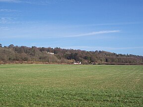
Downe Bank
Downe Bank is a nature reserve in the North Downs, close to Downe in the London Borough of Bromley. Located close to Charles Darwin’s home, Down House, it was one of his favourite places and helped to inspire his work.
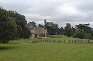
Titsey Place
Titsey Place was built by Sir John Gresham (1495–1556) on the site of a earlier dwelling. The mostly Tudor house was demolished and rebuilt in the 18th century, before being refronted in 1826. Finally a tower was added in 1856.

Tatsfield Receiving Station
The Tatsfield Receiving Station was a radio broadcasting signals-receiving and frequency-measuring facility operated by the British Broadcasting Corporation. The station was in operation between 1929 and 1974.
Betsom’s Hill
Betsom’s Hill is the highest point in the county of Kent at 251 metres (823 ft) Situated between Westerham and Tatsfield, at the western edge of the county. It lies close to where the A233 crosses the Downs en route to Biggin Hill.
Visit Aperfield plaques
 2
2
plaques
here Aperfield has 2 physical plaques in tourist plaque schemes for you to explore via Walkfo Aperfield plaques audio map when visiting. Plaques like National Heritage’s “Blue Plaques” provide visual geo-markers to highlight points-of-interest at the places where they happened – and Walkfo’s AI has researched additional, deeper content when you visit Aperfield using the app. Experience the history of a location when Walkfo local tourist guide app triggers audio close to each Aperfield plaque. Explore Plaques & History has a complete list of Hartlepool’s plaques & Hartlepool history plaque map.


 Trying to encourage visitors to Aperfield?