Welcome to Visit Ambleside Places
The Walkfo guide to things to do & explore in Ambleside
 Visit Ambleside places using Walkfo for free guided tours of the best Ambleside places to visit. A unique way to experience Ambleside’s places, Walkfo allows you to explore Ambleside as you would a museum or art gallery with audio guides.
Visiting Ambleside Walkfo Preview
Historically in Westmorland, it marks the head (and sits on the east side of the northern headwater) of Windermere, England’s largest natural lake. It is south of the highest road pass in the Lake District, Kirkstone Pass, and both places are the meeting point of well-marked paths and hiking trails. When you visit Ambleside, Walkfo brings Ambleside places to life as you travel by foot, bike, bus or car with a mobile phone & headphones.
Ambleside Places Overview: History, Culture & Facts about Ambleside
Visit Ambleside – Walkfo’s stats for the places to visit
With 38 audio plaques & Ambleside places for you to explore in the Ambleside area, Walkfo is the world’s largest heritage & history digital plaque provider. The AI continually learns & refines facts about the best Ambleside places to visit from travel & tourism authorities (like Wikipedia), converting history into an interactive audio experience.
Ambleside history
The town’s name is derived from the Old Norse “Á-mel-sǽtr” which literally translates as “river – sandbank – summer pasture” To the south of Ambleside is the Roman fort of Galava, dating from AD 79. In 1650 the town was granted a charter to hold a market and collect tolls.
Ambleside economy & business
Local government services
Ambleside is co-administered by South Lakeland District Council and in minor matters forms part of the Lakes civil parish. Cumbria County Council is the other main co–administration.
Tourist amenities
“Steamers” are the throwback name for the ferries (diesel-propelled) which run most days to Bowness-on-Windermere and Lakeside. Ambleside is a base for hiking, mountaineering and mountain biking.
Ambleside landmarks
Bridge House
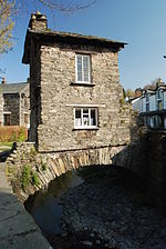
Bridge House was built over Stock Ghyll more than 300 years ago, probably as a summer house and apple store for Ambleside Hall. It was purchased by local people in 1926 and given to the National Trust. Listed Grade I, the building is now used as an information centre for the Trust.
St Mary’s Church

St Mary’s Church was built in the 1850s to a design by George Gilbert Scott in the Gothic Revival style. Notable features include: the stone spire, an unusual feature in Westmorland churches, the mural depicting rushbearing (a ceremony which is held on the first Saturday in July)
Mater Amabilis church
The town’s many decades-old Catholic Church in a traditional design is a consolidation of two churches. Until 2013 nearby Grasmere held services, whose reverend, Kevan Dorgan was translated to the consolidated parish.
Why visit Ambleside with Walkfo Travel Guide App?
 You can visit Ambleside places with Walkfo Ambleside to hear history at Ambleside’s places whilst walking around using the free digital tour app. Walkfo Ambleside has 38 places to visit in our interactive Ambleside map, with amazing history, culture & travel facts you can explore the same way you would at a museum or art gallery with information audio headset. With Walkfo, you can travel by foot, bike or bus throughout Ambleside, being in the moment, without digital distraction or limits to a specific walking route. Our historic audio walks, National Trust interactive audio experiences, digital tour guides for English Heritage locations are available at Ambleside places, with a AI tour guide to help you get the best from a visit to Ambleside & the surrounding areas.
“Curated content for millions of locations across the UK, with 38 audio facts unique to Ambleside places in an interactive Ambleside map you can explore.”
Walkfo: Visit Ambleside Places Map
38 tourist, history, culture & geography spots
Ambleside historic spots | Ambleside tourist destinations | Ambleside plaques | Ambleside geographic features |
| Walkfo Ambleside tourism map key: places to see & visit like National Trust sites, Blue Plaques, English Heritage locations & top tourist destinations in Ambleside | |||
Best Ambleside places to visit
Ambleside has places to explore by foot, bike or bus. Below are a selection of the varied Ambleside’s destinations you can visit with additional content available at the Walkfo Ambleside’s information audio spots:
 | Foxghyll Country House, Ambleside Foxghyll Country House is Grade II listed on the English Heritage Register. It is a Regency building which seems to have been added to a much older house that was on the site. It was the home of many notable people including Thomas De Quincey. |
 | Scandale Beck Scandale Beck arises in Lake District National Park on Bakestones Moss, west of Kirkstone Pass, and flows south for much of its length of six and a half kilometers. It flows under High Sweden Bridge, a 17th-century packhorse bridge, before turning west for a short distance north of Papermill Coppice. The Rothay flows south to join the River Rothay east of Ambleside before emptying into Windermere, England’s largest natural lake. |
 | Todd Crag Todd Crag is a satellite peak of Loughrigg Fell at 224 m (735 ft) It is not classed as a fell but is a vantage point near Ambleside. |
 | Loughrigg Fell Loughrigg Fell is a hill in the central part of the English Lake District. It stands on the end of the long ridge coming down from High Raise over Silver How towards Ambleside. |
 | Rydal Water Rydal Water is 1,290 yards (1.18 km) long and varies in width up to a maximum of 380 yards (350m) It has a maximum depth of 55 ft (17m) and an elevation above sea level of 177 ft (54m) The lake is both supplied and drained by the river Rothay, which flows from Grasmere upstream and towards Windermere downstream. The waters of the southern half of the lake are leased by the Lowther Estate to the National Trust. |
 | Rydal Mount Rydal Mount is best known as the home of William Wordsworth from 1813 to his death in 1850. It is currently operated as a writer’s home museum. |
 | Rydal Hall Rydal Hall is Grade II* listed on the National Heritage List for England. It has an early nineteenth-century front facade, but includes some earlier fabric. The summerhouse, game larder, and ice house in the grounds of the hall are all individually Grade II*. |
 | The Samling Hotel, Windermere The Samling Hotel was built as a villa in 1780 by John Benson who was the landlord of William Wordsworth. It was the home of several famous tenants over the next century and became a tourist attraction. The ownership of the house remained with the Benson family until about 1960. |
 | Langdale Chase Langdale Chase, Windermere is a house of historical significance and is listed on the English heritage register. It consists of six acres of landscaped gardens sloping from the Langdale. Chase Hotel in Cumbria in the Lake District of north west England. |
 | Wansfell Wansfell is a fell in the English Lake District situated 1½ miles (2.5 kilometres) east of the town of Ambleside. The fell is part of the long southern ridge of Caudale Moor and occupies the swath of territory between Ambleide and the Troutbeck valley. |
Visit Ambleside plaques
 7
7
plaques
here Ambleside has 7 physical plaques in tourist plaque schemes for you to explore via Walkfo Ambleside plaques audio map when visiting. Plaques like National Heritage’s “Blue Plaques” provide visual geo-markers to highlight points-of-interest at the places where they happened – and Walkfo’s AI has researched additional, deeper content when you visit Ambleside using the app. Experience the history of a location when Walkfo local tourist guide app triggers audio close to each Ambleside plaque. Explore Plaques & History has a complete list of Hartlepool’s plaques & Hartlepool history plaque map.


 Trying to encourage visitors to Ambleside?