Welcome to Visit Ambergate Places
The Walkfo guide to things to do & explore in Ambergate
 Visit Ambergate places using Walkfo for free guided tours of the best Ambergate places to visit. A unique way to experience Ambergate’s places, Walkfo allows you to explore Ambergate as you would a museum or art gallery with audio guides.
Visiting Ambergate Walkfo Preview
Ambergate is a village in Derbyshire, England, situated where the River Amber joins the River Derwent. It is about 6 miles (9.7 km) south of Matlock at the junction of the A6 trunk road and the A610 to Ripley. The name Amber Gate was originally applied to the tollgate for the Nottingham turnpike, but adopted by the North Midland Railway. The main railway line runs through the elliptical Toadmoor Tunnel designed by George Stephenson. When you visit Ambergate, Walkfo brings Ambergate places to life as you travel by foot, bike, bus or car with a mobile phone & headphones.
Ambergate Places Overview: History, Culture & Facts about Ambergate
Visit Ambergate – Walkfo’s stats for the places to visit
With 37 audio plaques & Ambergate places for you to explore in the Ambergate area, Walkfo is the world’s largest heritage & history digital plaque provider. The AI continually learns & refines facts about the best Ambergate places to visit from travel & tourism authorities (like Wikipedia), converting history into an interactive audio experience.
Why visit Ambergate with Walkfo Travel Guide App?
 You can visit Ambergate places with Walkfo Ambergate to hear history at Ambergate’s places whilst walking around using the free digital tour app. Walkfo Ambergate has 37 places to visit in our interactive Ambergate map, with amazing history, culture & travel facts you can explore the same way you would at a museum or art gallery with information audio headset. With Walkfo, you can travel by foot, bike or bus throughout Ambergate, being in the moment, without digital distraction or limits to a specific walking route. Our historic audio walks, National Trust interactive audio experiences, digital tour guides for English Heritage locations are available at Ambergate places, with a AI tour guide to help you get the best from a visit to Ambergate & the surrounding areas.
“Curated content for millions of locations across the UK, with 37 audio facts unique to Ambergate places in an interactive Ambergate map you can explore.”
Walkfo: Visit Ambergate Places Map
37 tourist, history, culture & geography spots
Ambergate historic spots | Ambergate tourist destinations | Ambergate plaques | Ambergate geographic features |
| Walkfo Ambergate tourism map key: places to see & visit like National Trust sites, Blue Plaques, English Heritage locations & top tourist destinations in Ambergate | |||
Best Ambergate places to visit
Ambergate has places to explore by foot, bike or bus. Below are a selection of the varied Ambergate’s destinations you can visit with additional content available at the Walkfo Ambergate’s information audio spots:
 | National Tramway Museum The National Tramway Museum is a tram museum located at Crich, Derbyshire. The museum contains over 60 (mainly British) trams built between 1873 and 1982. Most of the UK tram networks, with a few exceptions closed before the 1960s. |
 | St Mary’s Church, Crich St Mary’s Church, Crich is a Grade I listed parish church in Crich, Derbyshire. It was built in the 1930s and is now a Grade II listed parish. |
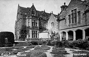 | Chase Cliffe Chase Cliffe is a building situated between the villages of Whatstandwell and Crich in Derbyshire. The house was built in 1859 by the three sisters of then deceased Francis Hurt. |
 | Oakhurst House Oakhurst House was built in 1848 by Francis Hurt behind his iron forge in Ambergate, Derbyshire. It was owned by the Johnson family of industrialists who were benefactors in the local area. |
 | St Luke’s Church, Heage St Luke’s Church, Heage is a Grade II* listed parish church in Derbyshire. It was built in the 1930s and is located in Heage. |
 | St Peter’s Church, Belper St Peter’s Church, Belper is a Grade II listed parish church in the Church of England in Derbyshire. It is located in the town of Belper in the district of Derby. |
 | Belper Congregational Church Belper Congregational Church is a Grade II listed former congregational chapel on Green Lane in Belper, Derbyshire. It was built in the 1930s and is now a Grade I listed former congregation chapel. |
 | Belper Baptist Church Belper Baptist Church is a Baptist Chapel on Bridge Street in Belper, Derbyshire. It is located in the town of Belper. |
 | Christ Church, Belper Christ Church is a Grade II listed parish church in the Church of England in Belper, Derbyshire. It is located in the town of Belper in the area. |
| Belper United F.C. Belper United Football Club is a football club based in Belper, Derbyshire. They are currently members of the United Counties League Division One. They play at Christchurch Meadow, the home of Belper Town. |
Visit Ambergate plaques
 8
8
plaques
here Ambergate has 8 physical plaques in tourist plaque schemes for you to explore via Walkfo Ambergate plaques audio map when visiting. Plaques like National Heritage’s “Blue Plaques” provide visual geo-markers to highlight points-of-interest at the places where they happened – and Walkfo’s AI has researched additional, deeper content when you visit Ambergate using the app. Experience the history of a location when Walkfo local tourist guide app triggers audio close to each Ambergate plaque. Explore Plaques & History has a complete list of Hartlepool’s plaques & Hartlepool history plaque map.


 Trying to encourage visitors to Ambergate?