Welcome to Visit Abronhill Places The Walkfo guide to things to do & explore in Abronhill
Visit Abronhill places using Walkfo for free guided tours of the best Abronhill places to visit. A unique way to experience Abronhill’s places, Walkfo allows you to explore Abronhill as you would a museum or art gallery with audio guides.
Visiting Abronhill Walkfo Preview Abronhill (/eɪˈbrɒnhɪl/) is an area in the north-east of Cumbernauld, North Lanarkshire, Scotland. It is about a mile or two from Cumbernauld Town Centre. Abronhill was planned with its own shopping centre and has three primary schools, along with several churches. Abronhill has 41 streets. Abronhill, and particularly the now-demolished Abronhill High School, (shut down in 2014 with secondary pupils now attending Cumbernauld Academy), were used extensively as the filming location for Bill Forsyth’s 1981 film Gregory’s Girl and its sequel Gregory’s Two Girls. All of the roads in the older part of Abronhill were named after a tree for example Cedar Road or Oak Road. This is in contrast to other parts of the New Town where historic local placenames or famous Scots or their art were incorporated into the street names. Abronhill, along with Condorrat and The Village, is one of the parts of Cumbernauld with buildings which pre-date the New Town although Abronhill was very small even compared to those modest settlements. Condorrat, the Village, Arns (near Abronhill see an old map) and Garbethill all had schools in the 19th century. The area around modern Abronhill is still mainly farmland and woodland, although there is a new housing estate with 600 homes due to be built to the north of Forest Rd . Palacerigg Country Park and Fannyside Lochs are nearby. There is also a small shopping centre, but this is falling into disrepair which has upset some of the residents. Abronhill has expanded in recent years with the development of Whitelees, which boasts its own primary school and housing estate, and Cherry Avenue which is built on the site of the former Glenhead primary school. This school was originally St.Lucy’s RC Primary School, however, falling roll at the nearby non-denominational Glenhead Primary School, saw the two schools swap locations. The name Abronhill comes from the 17th century, during the Wars of the Three Kingdoms, when the area was named Abraham the Hebrew’s Hill by the Covenanters. The name gradually changed to Abram’s Hill and then to Abronhill. There was a period in Scotland when it was a capital offense to preach at unauthorized religious assemblies so the Covenanters chose meeting places like this hilltop with an eye on escape. Ringleaders caught at these banned meetings would face the boot, or thumbscrews, or worse during the period known as The Killing Time. The death penalty was imposed on those who refused to swear an oath deliberately designed offend their conscience. Field executions were authorized so there were no lengthy trials. Locally covenanters were also reported to have met at Herd’s Hill on Fannyside to worship without the king’s restrictions. At least two local farmers had all their property confiscated at trials they did not attend. Until the New Town’s development, the land that is now Abronhill was occupied by farms such as Whitelees, Glenhead, Low Abronhill and High Abronhill. These farms had developed from the Fleming estate; the Flemings were the ruling family in the area, living at Cumbernauld Castle. They acquired the estate after Robert the Bruce murdered the previous laird, Red Comyn. The four original Abronhill cottages were from before the new town arrived. They were built for the workers of the nearby farms, and are situated on the old Slamannan Road which ran from Wardpark through the Glen and all the way to Slamannan. The site can still be found close to Cumbernauld Glen on what’s now known as Broom Road. Nearby is the Dovecote (Doocot in Scots), a 16th-century historical site of interest, which was part of the original Flemming’s estate. This received a grant to be renovated from North Lanarkshire’s Environmental Key Fund via the Scottish Wildlife Trust. Other local industry which pre-dates the new town includes weaving and mining. Entrances to old mines can be seen at the Glen and other places around the area. To the west of Abronhill and separating it from Kildrum is a deep geographical divide called the Vault Glen. Through the Vault Glen runs a river, a pipeline which carries sewage and the railway line. The river, initially called the Glencryan Burn, starts from Fannyside Lochs and runs through Glencryan Reservoir and down to Forest Road, the main road to Abronhill. The river then runs under the road and its name changes to The Red Burn on the other side, behind Cumbernauld Academy. (On older maps the river was sometimes still called Glencryan Burn for part of its way through the Vault Glen). There are four footbridges connecting Abronhill with the rest of the town: one on either side of Cumbernauld Academy, one close to Abronhill Primary School and one at Broom Road. This Red Burn is the one from which Cumbernauld’s Gaelic name is derived. There is a gruesome story about how the Red Burn (or Redburn) itself was named. It involves the killing of Roman soldiers whose bodies were dumped in the river at Castlecary making it run red. When you visit Abronhill, Walkfo brings Abronhill places to life as you travel by foot, bike, bus or car with a mobile phone & headphones.
Abronhill Places Overview: History, Culture & Facts about Abronhill
Visit Abronhill – Walkfo’s stats for the places to visit
With 25 audio plaques & Abronhill places for you to explore in the Abronhill area, Walkfo is the world’s largest heritage & history digital plaque provider. The AI continually learns & refines facts about the best Abronhill places to visit from travel & tourism authorities (like Wikipedia), converting history into an interactive audio experience.
Why visit Abronhill with Walkfo Travel Guide App?
You can visit Abronhill places with Walkfo Abronhill to hear history at Abronhill’s places whilst walking around using the free digital tour app. Walkfo Abronhill has 25 places to visit in our interactive Abronhill map, with amazing history, culture & travel facts you can explore the same way you would at a museum or art gallery with information audio headset. With Walkfo, you can travel by foot, bike or bus throughout Abronhill, being in the moment, without digital distraction or limits to a specific walking route. Our historic audio walks, National Trust interactive audio experiences, digital tour guides for English Heritage locations are available at Abronhill places, with a AI tour guide to help you get the best from a visit to Abronhill & the surrounding areas.
“Curated content for millions of locations across the UK, with 25 audio facts unique to Abronhill places in an interactive Abronhill map you can explore.”
Walkfo Abronhill tourism map key: places to see & visit like National Trust sites, Blue Plaques, English Heritage locations & top tourist destinations in Abronhill
Best Abronhill places to visit
Abronhill has places to explore by foot, bike or bus. Below are a selection of the varied Abronhill’s destinations you can visit with additional content available at the Walkfo Abronhill’s information audio spots:
Carrickstone Carrickstone is on the north of the M80 and west of Cumbernauld Town Centre. The area it now occupies used to be covered by a farm.
Cumbernauld town centre Cumbernauld town centre was designed in the 1950s as a megastructure. Phase 1 was completed between 1963 and 1967, and the centre was opened by Princess Margaret and Lord Snowdon in May 1967. It was expanded in 2007 by the addition of the Antonine Centre, a shopping centre linked to the older structure by walkways and lifts.
Cumbernauld Village Cumbernauld was designated a new town in 1955. The Village has a pre-mediaeval history, with a Roman settlement being built in the area due to its proximity to the Antonine Wall. After the Roman period the settlement remained and grew to such an extent that the Comyns family built their chapel there.
Kildrum Kildrum was the first area to be constructed in Cumbernauld new town, North Lanarkshire, Scotland. It provided housing for workers at Burroughs factory at Old Inns. The main road is in the shape of an arc with residential streets leading from it.
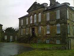
Cumbernauld House Cumbernauld House is an 18th-century Vivido Scottish country house. It was built in 1731, to designs by William Adam, for John Fleming, 6th Earl of Wigtown. The house is situated on the site of (former) Cumbernault Castle, which was besieged by General Monck in 1651.
Cumbernauld Castle The Motte of the earliest castle survives, and stones of the second castle are incorporated in the present house. Cumbernauld Castle was the predecessor of Cumbernault House in the Park.
Castle Cary Castle Castle Cary Castle is 6 miles (10 km) from Falkirk in the former county of Stirlingshire, Scotland. It is located near to the site of one of the principal forts of the Roman Antonine Wall.
Red Burn The Red Burn is one of two main streams which flow out of Cumbernauld. The Scottish New Town’s name derives from the Gaelic for “the meeting of the waters”
Visit Abronhill plaques
0 plaques hereAbronhill has 0 physical plaques in tourist plaque schemes for you to explore via Walkfo Abronhill plaques audio map when visiting. Plaques like National Heritage’s “Blue Plaques” provide visual geo-markers to highlight points-of-interest at the places where they happened – and Walkfo’s AI has researched additional, deeper content when you visit Abronhill using the app. Experience the history of a location when Walkfo local tourist guide app triggers audio close to each Abronhill plaque. Currently No Physical Plaques.
Experience Abronhill audio walks & tours
Walkfo guides for things to do / places to visit in Abronhill allows exploration as you would do an art gallery or museum. Walk close to one of Abronhill’s 25 historic places & our digital tour guide will create an audio story for that spot. With headphone connected, you can explore Abronhill freely by foot, bike or bus – with your own personal tour guide in your pocket.
Explore Abronhill Map App
Our visit Abronhill map shows you things-to-do & places you can visit in Abronhill & surrounding areas using the Walkfo digital audio tour guide app. Each spot has plaque, building, street or area information on history, culture or tourism.
You can set your Walkfo’s Abronhill tourist map to find historic & tourism spots within 1km, 3km & 5km of the Abronhill centre, depending on how far you plan to explore whilst you visit Abronhill area at LONG:-3.947, LAT:55.963.
Walkfo App
Walkfo
Walkfo is free to download & use (for a limited time period), so if you are looking to explore Abronhill, go to your App Store to search for “Walkfo” or follow a links below and install on your mobile phone. Walkfo is designed for use with headphones or AirPods, so you can walk & explore whilst learning about the things around you without digital distraction.
Things to do & visit in Abronhill / surrounding areas
● Carrickstone ● Seafar ● Cumbernauld ● Antonine Centre ● Cumbernauld town centre ● Cumbernauld Village ● Westerwood ● Carbrain ● Kildrum ● Lenziemill ● Cumbernauld House ● Cumbernauld Castle ● Abronhill ● Wardpark ● Cumbernauld Airport ● Castle Cary Castle ● Castlecary ● Castlecary rail accidents ● Red Burn ● Banknock ● Longcroft, Falkirk ● Allandale, Falkirk ● Braeface ● Kelvinhead ● Cumbernauld United F.C.
Getting to / around Abronhill – transport link, station & street map
Getting around in Abronhill using public transportation may include road, street, train, underground, bus or tram transport options. Walkfo has identified the following Abronhill places with historic / cultural / factual content when you visit:
Local Abronhill Public Transport Stations
Abronhill Notable Streets & Road Destinations
Cumbernauld railway station
Castlecary railway station
Allandale railway station
Upper Greenhill railway station
Banknock railway station
[transportsummary]
Local Abronhill historians & Abronhill tour guides
Trying to encourage visitors to Abronhill? Walkfo has millions audio places already available but Walkfo Creator gives Abronhill’s places, attractions & landmarks ability to create their own unique outdoor audio museums & using our simple & easy to use Walkfo Creator. – Creating a new audio experience for your Abronhill place is free* and quick (15+ minutes if you prepare text content) to use, with Walkfo Creator doing the hard work of generating AI audio files for geo-spots from the text you provide with a simply click on a map. – The 100 Amazing Abronhill Places is just one example of an outdoor museum created using Walkfo Creator (pictured to the left) for people to safely explore during Covid-19 times whilst visiting a city. Our tool is open to tourism organisations, travel destinations & National Trust locations to create their own audio walks to offer free when people visit Abronhill destinations. – Walkfo itself is looking to partner with websites offering things-to-do / what’s on events listings to enhance the content of our ‘visit-Abronhill’ web pages (for example: www.visitAbronhill.com). If you are interested in partnering, please contact us to discuss options.
* Walkfo Creator is free to use for a limited number of audio spots within a map with a license fee applicable when more than 20 audio spots within location walk are created. v1.1336
 Visit Abronhill places using Walkfo for free guided tours of the best Abronhill places to visit. A unique way to experience Abronhill’s places, Walkfo allows you to explore Abronhill as you would a museum or art gallery with audio guides.
 You can visit Abronhill places with Walkfo Abronhill to hear history at Abronhill’s places whilst walking around using the free digital tour app. Walkfo Abronhill has 25 places to visit in our interactive Abronhill map, with amazing history, culture & travel facts you can explore the same way you would at a museum or art gallery with information audio headset. With Walkfo, you can travel by foot, bike or bus throughout Abronhill, being in the moment, without digital distraction or limits to a specific walking route. Our historic audio walks, National Trust interactive audio experiences, digital tour guides for English Heritage locations are available at Abronhill places, with a AI tour guide to help you get the best from a visit to Abronhill & the surrounding areas.


 0
0


 Trying to encourage visitors to Abronhill?