Welcome to Visit Wylam Places
The Walkfo guide to things to do & explore in Wylam
 Visit Wylam places using Walkfo for free guided tours of the best Wylam places to visit. A unique way to experience Wylam’s places, Walkfo allows you to explore Wylam as you would a museum or art gallery with audio guides.
Visiting Wylam Walkfo Preview
Wylam is located 10 miles (16 km) west of Newcastle upon Tyne. It is famous for being the birthplace of George Stephenson, one of the early railway pioneers. Timothy Hackworth, who worked with Stephenson, was also born here. When you visit Wylam, Walkfo brings Wylam places to life as you travel by foot, bike, bus or car with a mobile phone & headphones.
Wylam Places Overview: History, Culture & Facts about Wylam
Visit Wylam – Walkfo’s stats for the places to visit
With 25 audio plaques & Wylam places for you to explore in the Wylam area, Walkfo is the world’s largest heritage & history digital plaque provider. The AI continually learns & refines facts about the best Wylam places to visit from travel & tourism authorities (like Wikipedia), converting history into an interactive audio experience.
Wylam history
Wylam is a commuting village for Newcastle upon Tyne and Hexham, served by the Newcastle and Carlisle Railway. The earliest reference to the village is in a record of 1158 that records that the settlement belonged to the priory at Tynemouth. The Blackett family have had a long association with the village. In 1659 Christopher Blackett acquired the Lordship of the Manor of Wylam on the death of his wife’s father, Thomas Fenwick. Following Christopher’s death, his second son, John Blackett, took over the estate and purchased additional land in the area.
Wylam culture & places
Wylam Winter Tales is a not-for-profit arts and culture festival held in the village every January/February. It features a week of varied events including music, storytelling, film, crafts and history.
Wylam landmarks

Wylam Railway Bridge is located at Hagg Bank, approximately 1 mile (1.6 km) west of the town. It is a wrought iron bridge built by the Scotswood, Newburn and Wylam railway Company in 1876 to link the North Wylam Loop with the Newcastle and Carlisle Railway. The original plan had been to build a bridge with four spans resting on three piers on the river bed. This was rejected by the local coal companies who feared the construction of the piers would disturb the shallow mine workings below.
Wylam geography / climate
Wylam is located on the north and south sides of the River Tyne in Northumberland. The riverside walks and country trails surrounding the village are popular for cyclists, runners and walkers alike. To the east of Wylam railway station is the mouth of the small brook known as Stanley Burn.
Why visit Wylam with Walkfo Travel Guide App?
 You can visit Wylam places with Walkfo Wylam to hear history at Wylam’s places whilst walking around using the free digital tour app. Walkfo Wylam has 25 places to visit in our interactive Wylam map, with amazing history, culture & travel facts you can explore the same way you would at a museum or art gallery with information audio headset. With Walkfo, you can travel by foot, bike or bus throughout Wylam, being in the moment, without digital distraction or limits to a specific walking route. Our historic audio walks, National Trust interactive audio experiences, digital tour guides for English Heritage locations are available at Wylam places, with a AI tour guide to help you get the best from a visit to Wylam & the surrounding areas.
“Curated content for millions of locations across the UK, with 25 audio facts unique to Wylam places in an interactive Wylam map you can explore.”
Walkfo: Visit Wylam Places Map
25 tourist, history, culture & geography spots
Wylam historic spots | Wylam tourist destinations | Wylam plaques | Wylam geographic features |
| Walkfo Wylam tourism map key: places to see & visit like National Trust sites, Blue Plaques, English Heritage locations & top tourist destinations in Wylam | |||
Best Wylam places to visit
Wylam has places to explore by foot, bike or bus. Below are a selection of the varied Wylam’s destinations you can visit with additional content available at the Walkfo Wylam’s information audio spots:
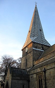
Holy Cross Church, Ryton
Holy Cross Church is a Church of England parish church in Ryton, Tyne and Wear. The church is a Grade I listed building.

Greenside, Tyne and Wear
Greenside is a village in the extreme west of the Metropolitan County of Tyne and Wear. Once an independent village in County Durham, it became incorporated into Tyne & Wear in 1974 and then the Metropolitan Borough of Gateshead in 1986.

Close House, Northumberland
Close House is a country estate near Heddon-on-the-Wall, Northumberland. The estate contains a Grade II* listed former mansion house, which is currently a private residence.

Newcastle University F.C.
Newcastle University Football Club is a football club based in Newcastle upon Tyne, Tyne and Wear, England. They are currently members of the Northern League Division Two and play at Kimberley Park, groundsharing with Prudhoe Town.

Prudhoe Town F.C.
Prudhoe Town Football Club is a football club based in Northumberland, England. They play at Kimberley Park. The club is affiliated to the Northumberlands Football Association.
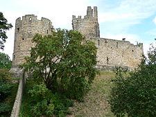
Prudhoe Castle
Prudhoe Castle is a ruined medieval English castle situated on the south bank of the River Tyne in Northumberland. It is a Scheduled Ancient Monument and Grade I listed building.
Prudhoe
Prudhoe has a population of over 11,500, measured at 11,675 in the 2011 Census. Today, it has largely become a commuter town for nearby Newcastle.

Milecastle 12
Milecastle 12 was a milecastle of the Roman Hadrian’s Wall. Its remains lay under Town Farm, Heddon-on-the-Wall, (just opposite the farm house)

Vindobala
Vindobala was the fourth fort on Hadrian’s Wall, after Segedunum and Pons Aelius. It was situated about 11 kilometres (6.8 mi) west of Condercum. The site of the fort is bisected by the B6318 Military Road, which runs along the route of the wall.
Milecastle 13
Milecastle 13 (Rudchester Burn) was a milecastle of the Roman Hadrian’s Wall. Its remains exist as a low platform south of the B6318 Military Road.
Visit Wylam plaques
 1
1
plaques
here Wylam has 1 physical plaques in tourist plaque schemes for you to explore via Walkfo Wylam plaques audio map when visiting. Plaques like National Heritage’s “Blue Plaques” provide visual geo-markers to highlight points-of-interest at the places where they happened – and Walkfo’s AI has researched additional, deeper content when you visit Wylam using the app. Experience the history of a location when Walkfo local tourist guide app triggers audio close to each Wylam plaque. Explore Plaques & History has a complete list of Hartlepool’s plaques & Hartlepool history plaque map.


 Trying to encourage visitors to Wylam?