Welcome to Visit Walderslade Places
The Walkfo guide to things to do & explore in Walderslade
 Visit Walderslade places using Walkfo for free guided tours of the best Walderslade places to visit. A unique way to experience Walderslade’s places, Walkfo allows you to explore Walderslade as you would a museum or art gallery with audio guides.
Visiting Walderslade Walkfo Preview
Walderslade is a large suburb in Kent to the south of Chatham split between the unitary authority of Medway and the boroughs of Maidstone and Tonbridge & Malling in South East England. It was, until 1998, fully part of Kent and is still ceremonially associated via the Lieutenancies Act. When you visit Walderslade, Walkfo brings Walderslade places to life as you travel by foot, bike, bus or car with a mobile phone & headphones.
Walderslade Places Overview: History, Culture & Facts about Walderslade
Visit Walderslade – Walkfo’s stats for the places to visit
With 42 audio plaques & Walderslade places for you to explore in the Walderslade area, Walkfo is the world’s largest heritage & history digital plaque provider. The AI continually learns & refines facts about the best Walderslade places to visit from travel & tourism authorities (like Wikipedia), converting history into an interactive audio experience.
Walderslade history
Walderslade Valley or Bottom – is one of several dry chalk valleys in the area, that were created during past ice ages as a result of melting ice when England was still joined with the continent. During warmer post glacial periods, elephants and hippopotami roamed the valleys. Woodland cleared to supply Chatham Dockyard with oak for the building of wooden sailing ships.
Walderslade geography / climate
Walderslade is separated from the rest of the Medway towns by a green belt incorporating Rochester Airport, Horsted Farm and the Coney Bank to the north. There is a small link via Luton, which is connected to Wayfield and Princes Avenue estates.
Walderslade village
The centre of Walderslade village comprises St William’s Church, a health centre including doctors’ surgeries, a Co-op supermarket, a public house and a nursery. The Alexandra Hospital (Spire – no A&E) is located on the outskirts of the village. There is ample free public car parking offered by the supermarket and in front of most of the shops.
Princes Park
Princes Park is lower down the valley to the north. It has a community hall, pub, newsagents, Indian Takeaway and a supermarket. The original farm house, which is a mid 17th century, Grade II listed building, can still be seen by the observant.
Davis Estate
Davis Estate has a community hall, a parade of shops including a post office, newsagents and several takeaways. Neighbouring is the Horsted retail park where several large retailers are located.
Walderslade Woods
Walderslade Woods (aka little nel’s woods) is a recent development, begun before the 1970s, to the south of the village near the M2 motorway. The whole area is now protected by having Village Green Status, and so cannot be developed by Kent County Council.
Weedswood
Weedswood, to the north and north west of Walderslade village, has a parade of shops, the Poacher’s Pocket pub and a kebab shop. There are two churches, Emmanuel (Congregational Federation) and St Philip & St James.
Wayfield Estate
Wayfield is to the north of Weedswood above and alongside the Princes Avenue area. It has several small shops, a woodyard, a golf driving range with a pitch and putt golf course, a Fitness First gym and a playing field.
Lordswood
Lordswood is a large development, also to the east, with two separate shopping parades. It has direct access to Chatham via North Dane Way (B2156), which hems in Walderslade. The wood of ‘Lords Wood’ originally extended for approximately one mile by three quarters.
Why visit Walderslade with Walkfo Travel Guide App?
 You can visit Walderslade places with Walkfo Walderslade to hear history at Walderslade’s places whilst walking around using the free digital tour app. Walkfo Walderslade has 42 places to visit in our interactive Walderslade map, with amazing history, culture & travel facts you can explore the same way you would at a museum or art gallery with information audio headset. With Walkfo, you can travel by foot, bike or bus throughout Walderslade, being in the moment, without digital distraction or limits to a specific walking route. Our historic audio walks, National Trust interactive audio experiences, digital tour guides for English Heritage locations are available at Walderslade places, with a AI tour guide to help you get the best from a visit to Walderslade & the surrounding areas.
“Curated content for millions of locations across the UK, with 42 audio facts unique to Walderslade places in an interactive Walderslade map you can explore.”
Walkfo: Visit Walderslade Places Map
42 tourist, history, culture & geography spots
Walderslade historic spots | Walderslade tourist destinations | Walderslade plaques | Walderslade geographic features |
| Walkfo Walderslade tourism map key: places to see & visit like National Trust sites, Blue Plaques, English Heritage locations & top tourist destinations in Walderslade | |||
Best Walderslade places to visit
Walderslade has places to explore by foot, bike or bus. Below are a selection of the varied Walderslade’s destinations you can visit with additional content available at the Walkfo Walderslade’s information audio spots:
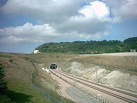
 | Fort Horsted Fort Horsted is a scheduled monument (Monument Number 416040) that lies in the Horsted Valley to the South of Chatham, Kent, England. It is a late 19th-century Land Fort, and one of six constructed around Chatham and Gillingham, Kent to protect HM Dockyard Chatham from attack. |
 | HM Prison Cookham Wood HM Prison Cookham Wood is a male young person’s’ prison and Young Offenders Institution in the village of Borstal (near Rochester) in Kent, England. The prison is operated by Her Majesty’s Prison and probation Service. |
 | Blue Bell Hill Blue Bell Hill is a chalk hill between Maidstone and Rochester in Kent. It overlooks the River Medway and is part of the North Downs. During the eighteenth and nineteenth centuries much of the hill was quarried for chalk. The hill is a 5-hectare (12-acre) nature reserve. |
 | Westfield Wood Westfield Wood is a 5-hectare (12-acre) nature reserve north of Maidstone in Kent. It is part of the Wouldham to Detling Escarpment Site of Special Scientific Interest and Nature Conservation Review site, Grade I. |
 | Kit’s Coty House Kit’s Coty House is a chambered long barrow near Aylesford in southeastern Kent. It was built circa 4000 BCE, during the Early Neolithic period of British prehistory. The name “Kits Coty” allegedly means “Tomb in the Forest” according to signs at the site. |
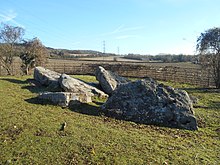 | Little Kit’s Coty House Kit’s Coty House is a chambered long barrow located near to the village of Aylesford in southeastern English county of Kent. Constructed circa 4000 BCE, during the Early Neolithic period of British prehistory, today it survives in a ruined state. |
 | Burham Down Burham Down is a 110-hectare nature reserve between Maidstone and Chatham in Kent. It is part of the Wouldham to Detling Escarpment Site of Special Scientific Interest and Nature Conservation Review site. |
 | Coffin Stone The Coffin Stone, also known as the Coffin and the Table Stone, is a large sarsen stone at the foot of Blue Bell Hill near Aylesford in the south-eastern English county of Kent. Now lying horizontally, the stone probably once stood upright nearby. Various archaeologists have argued that the stone was part of a now-destroyed chambered long barrow. |
 | Fort Bridgewoods Fort Bridgewoods is on the outskirts of Rochester, Medway, next to the Rochester-Maidstone road (B2097) The site was acquired by the War Office in about 1860 to form part of a ring of forts protecting the Royal Dockyard at Chatham. |
 | Medway Megaliths The Medway Megaliths are a group of Early Neolithic chambered long barrows and other megalithic monuments. Constructed from local sarsen stone and soil between 4th and 3rd millennia BCE. They represent the only known prehistoric megaliths in eastern England and the most south-easterly group in Britain. |
Visit Walderslade plaques
 0
0
plaques
here Walderslade has 0 physical plaques in tourist plaque schemes for you to explore via Walkfo Walderslade plaques audio map when visiting. Plaques like National Heritage’s “Blue Plaques” provide visual geo-markers to highlight points-of-interest at the places where they happened – and Walkfo’s AI has researched additional, deeper content when you visit Walderslade using the app. Experience the history of a location when Walkfo local tourist guide app triggers audio close to each Walderslade plaque. Currently No Physical Plaques.


 Trying to encourage visitors to Walderslade?