Welcome to Visit Stretford Places
The Walkfo guide to things to do & explore in Stretford
 Visit Stretford places using Walkfo for free guided tours of the best Stretford places to visit. A unique way to experience Stretford’s places, Walkfo allows you to explore Stretford as you would a museum or art gallery with audio guides.
Visiting Stretford Walkfo Preview
When you visit Stretford, Walkfo brings Stretford places to life as you travel by foot, bike, bus or car with a mobile phone & headphones.
Stretford Places Overview: History, Culture & Facts about Stretford
Visit Stretford – Walkfo’s stats for the places to visit
With 109 audio plaques & Stretford places for you to explore in the Stretford area, Walkfo is the world’s largest heritage & history digital plaque provider. The AI continually learns & refines facts about the best Stretford places to visit from travel & tourism authorities (like Wikipedia), converting history into an interactive audio experience.
Stretford history
The origin of the name Stretford is “street” (Old English stræt) on a ford across the River Mersey. The principal road, the A56 Chester Road, follows the line of the old Roman road from Deva Victrix (Chester) to Mamucium (Manchester), crossing the Mersey at Crossford Bridge, built at the location of the ancient ford.
Industrialisation
The arrival of the Manchester Ship Canal in 1894 and the development of the Trafford Park industrial estate in the north of the town had a substantial effect on Stretford’s growth . The population in 1891 was 21,751, but by 1901 it had increased by 40% to 30,436 .
Transport history
The Bridgewater Canal reached Stretford in 1761, and the railway in 1849 . The completion of the Manchester South Junction and Altrincham Railway (MSJAR) led to the population of the town nearly doubling in a decade, from 4,998 in 1851 to 8,757 by 1861 .
Stretford landmarks
Longford Cinema

Designed by Henry Elder, it was the height of Art Deco fashion when it was opened by the Mayor of Stretford in 1936 . Its unusual “cash register” frontage was intended to symbolise the business aspect of show business .
Great Stone

The Great Stone gave its name to the Great Stone Road, where it was located until being moved in 1925 . The stone is composed of millstone grit and was probably deposited as a glacial erratic . It is rectangular in shape, about 5 feet (2 m) wide, 2 feet (1 m) deep, and 3 feet .
Cenotaph

Stretford Cenotaph, opposite the Chester Road entrance to Gorse Hill Park, was built as a memorial to the 580 men who lost their lives in the First World War . It was formally unveiled in 1923 by the Earl of Derby, Secretary of State for War .
Longford Park
Longford Park is a popular attraction in Longford, Suffolk County, England . The park is located on the edge of Longford Road, near the town centre of the town .
Stretford Public Hall

Stretford Public Hall was built in 1878 by John Rylands . It was designed by N. Lofthouse and is on the western side of the A56 Chester Road . First public lending library was established in the building in 1883 .
Stretford Cemetery
Stretford Cemetery was designed by John Shaw and opened in 1885 . Its chapel is in the Decorated style, designed by architects Bellamy & Hardy . On the western side is a memorial to the casualties of the Second World War .
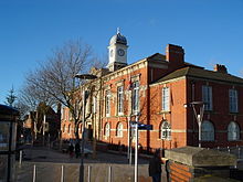
Trafford Town Hall
Trafford Town Hall stands in a large site at the junction of Talbot Road and Warwick Road, directly opposite the Old Trafford Cricket Ground . Work on the building was designed by architects Bradshaw Gass & Hope of Bolton .
Union Church
The Union Church was formed in 1862, with John Rylands as its patron . He laid the foundation stone of the building in Edge Lane, close to Longford Park’s southern entrance, in 1867 . In the latter part of the 20th century the church was converted into office accommodation . In 2012 it was restored to its original use having been bought by the Church of Christ – Iglesia ni Cristo .
Stretford geography / climate
Stretford occupies an area of 4.1 square miles (10.6 km) just north of the River Mersey. The area is generally flat, sloping slightly southwards towards the river valley, and is approximately 150 feet (46 m) above sea level at its highest point.
Why visit Stretford with Walkfo Travel Guide App?
 You can visit Stretford places with Walkfo Stretford to hear history at Stretford’s places whilst walking around using the free digital tour app. Walkfo Stretford has 109 places to visit in our interactive Stretford map, with amazing history, culture & travel facts you can explore the same way you would at a museum or art gallery with information audio headset. With Walkfo, you can travel by foot, bike or bus throughout Stretford, being in the moment, without digital distraction or limits to a specific walking route. Our historic audio walks, National Trust interactive audio experiences, digital tour guides for English Heritage locations are available at Stretford places, with a AI tour guide to help you get the best from a visit to Stretford & the surrounding areas.
“Curated content for millions of locations across the UK, with 109 audio facts unique to Stretford places in an interactive Stretford map you can explore.”
Walkfo: Visit Stretford Places Map
109 tourist, history, culture & geography spots
Stretford historic spots | Stretford tourist destinations | Stretford plaques | Stretford geographic features |
| Walkfo Stretford tourism map key: places to see & visit like National Trust sites, Blue Plaques, English Heritage locations & top tourist destinations in Stretford | |||
Best Stretford places to visit
Stretford has places to explore by foot, bike or bus. Below are a selection of the varied Stretford’s destinations you can visit with additional content available at the Walkfo Stretford’s information audio spots:

Hough End Hall
Hough End Hall is a historic house now in Chorlton-cum-Hardy, (originally in Withington), Manchester . It was built in 1596 during the reign of Queen Elizabeth I by Sir Nicholas Mosley . The Mosleys were an influential Mancunian family from the 16th century onwards .

Chorlton Poor Law Union
Chorlton Poor Law Union was founded in January 1837 in response to the Poor Law Amendment Act 1834 . It was overseen by an elected board of 19 guardians representing the 12 parishes in the area it served .

Southern Cemetery, Manchester
Southern Cemetery is a large municipal cemetery in Chorlton-cum-Hardy, Manchester, England . It opened in 1879 and is owned and administered by Manchester City Council . It is the second largest cemetery in Europe and the largest in the UK .

St Ann’s, Stretford
St Ann’s Church, Stretford is a Grade II listed Roman Catholic church . It was constructed between 1862 and 1863, on the east side of the A56 Chester Road . The parish functions under the jurisdiction of the Roman Catholic Diocese of Salford .

Municipal Borough of Stretford
Stretford was, from 1868 to 1974, a local government district coterminate with the town of Stretford, Lancashire.
Municipal Borough of Sale
Sale was, from 1867 to 1974, a district in Cheshire. The district had the status of local government district, urban district and municipal borough. Its area now forms part of the Metropolitan Borough of Trafford.

St Martin’s Church, Ashton upon Mersey
St Martin’s Church is in Church Lane, Ashton upon Mersey, a district of Sale, Greater Manchester. It is recorded in the National Heritage List for England as a designated Grade II* listed building.
![]()
Real Radio XS
Real Radio XS was a radio station brand operated by Real and Smooth Ltd (formerly GMG Radio) based in Salford, Greater Manchester, broadcasting a variety of peak-time news, rock music and talk output. The Manchester-based version of the service was broadcast to Greater Manchester on FM, and to a number of areas on DAB.

Harbour City tram stop
Harbour City is a tram stop on the Eccles Line of Greater Manchester’s light rail Metrolink system. It is located in the Salford Quays area, in North West England. It opened on 12 June 1999 as part of Phase 2 of the system’s expansion.
Dock10 (television facility)
Dock10 (stylised as dock10) is a television facility owner and media services company. Its studio filming facility is the best-known part of the company, often referred to as The Studios. It was built as a major part of MediaCityUK, a development in Salford, Greater Manchester.
Visit Stretford plaques
 20
20
plaques
here Stretford has 20 physical plaques in tourist plaque schemes for you to explore via Walkfo Stretford plaques audio map when visiting. Plaques like National Heritage’s “Blue Plaques” provide visual geo-markers to highlight points-of-interest at the places where they happened – and Walkfo’s AI has researched additional, deeper content when you visit Stretford using the app. Experience the history of a location when Walkfo local tourist guide app triggers audio close to each Stretford plaque. Explore Plaques & History has a complete list of Hartlepool’s plaques & Hartlepool history plaque map.


 Trying to encourage visitors to Stretford?