Welcome to Visit Stody Places
The Walkfo guide to things to do & explore in Stody
 Visit Stody places using Walkfo for free guided tours of the best Stody places to visit. A unique way to experience Stody’s places, Walkfo allows you to explore Stody as you would a museum or art gallery with audio guides.
Visiting Stody Walkfo Preview
The village is 13.2 miles (21.2 km) west south west of Cromer, 21.8 miles (35.1 km) north north west of Norwich. The nearest railway station is at Sheringham for the Bittern Line which runs between Sheringham, Cromer and Norwich. When you visit Stody, Walkfo brings Stody places to life as you travel by foot, bike, bus or car with a mobile phone & headphones.
Stody Places Overview: History, Culture & Facts about Stody
Visit Stody – Walkfo’s stats for the places to visit
With 13 audio plaques & Stody places for you to explore in the Stody area, Walkfo is the world’s largest heritage & history digital plaque provider. The AI continually learns & refines facts about the best Stody places to visit from travel & tourism authorities (like Wikipedia), converting history into an interactive audio experience.
Stody history
Stody has an entry in the Domesday Book of 1085. The name Stody derives from ‘an enclosure for horses’ The modern English word ‘stud’ comes from the same root.
Why visit Stody with Walkfo Travel Guide App?
 You can visit Stody places with Walkfo Stody to hear history at Stody’s places whilst walking around using the free digital tour app. Walkfo Stody has 13 places to visit in our interactive Stody map, with amazing history, culture & travel facts you can explore the same way you would at a museum or art gallery with information audio headset. With Walkfo, you can travel by foot, bike or bus throughout Stody, being in the moment, without digital distraction or limits to a specific walking route. Our historic audio walks, National Trust interactive audio experiences, digital tour guides for English Heritage locations are available at Stody places, with a AI tour guide to help you get the best from a visit to Stody & the surrounding areas.
“Curated content for millions of locations across the UK, with 13 audio facts unique to Stody places in an interactive Stody map you can explore.”
Walkfo: Visit Stody Places Map
13 tourist, history, culture & geography spots
Stody historic spots | Stody tourist destinations | Stody plaques | Stody geographic features |
| Walkfo Stody tourism map key: places to see & visit like National Trust sites, Blue Plaques, English Heritage locations & top tourist destinations in Stody | |||
Best Stody places to visit
Stody has places to explore by foot, bike or bus. Below are a selection of the varied Stody’s destinations you can visit with additional content available at the Walkfo Stody’s information audio spots:
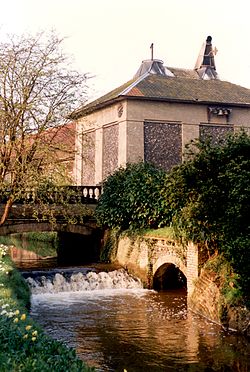
Letheringsett Brewery watermill
The watermill of 1784 was housed within the maltings and brewery complex founded and run by John Brereton of Letheringsett Hall from before 1721. Much of this complex still stands on the south side of the A148 Cromer to King’s Lynn road, which bisects the village on an east–west axis.

St Lawrence Parish Church, Hunworth
St Lawrence Parish Church is a Grade II* listed building in the village of Hunworth in Norfolk. The church is dedicated to Saint Lawrence who was martyred in 258 AD.
Visit Stody plaques
 0
0
plaques
here Stody has 0 physical plaques in tourist plaque schemes for you to explore via Walkfo Stody plaques audio map when visiting. Plaques like National Heritage’s “Blue Plaques” provide visual geo-markers to highlight points-of-interest at the places where they happened – and Walkfo’s AI has researched additional, deeper content when you visit Stody using the app. Experience the history of a location when Walkfo local tourist guide app triggers audio close to each Stody plaque. Currently No Physical Plaques.


 Trying to encourage visitors to Stody?