Welcome to Visit Stechford Places
The Walkfo guide to things to do & explore in Stechford
 Visit Stechford places using Walkfo for free guided tours of the best Stechford places to visit. A unique way to experience Stechford’s places, Walkfo allows you to explore Stechford as you would a museum or art gallery with audio guides.
Visiting Stechford Walkfo Preview
When you visit Stechford, Walkfo brings Stechford places to life as you travel by foot, bike, bus or car with a mobile phone & headphones.
Stechford Places Overview: History, Culture & Facts about Stechford
Visit Stechford – Walkfo’s stats for the places to visit
With 83 audio plaques & Stechford places for you to explore in the Stechford area, Walkfo is the world’s largest heritage & history digital plaque provider. The AI continually learns & refines facts about the best Stechford places to visit from travel & tourism authorities (like Wikipedia), converting history into an interactive audio experience.
Stechford history
Stechford’s history is unclear. Its oldest components are Station Road (known as Stoney Lane since Norman times) and Flaxleye Farm, first referenced in 1218. It has been conjectured that it was simply a railway misspelling.
Stechford geography / climate
The district is cut across by the River Cole, the Birmingham to London railway, and the Birmingham Outer Circle (A4040) It is also cut across the city’s Outer Circle.
Why visit Stechford with Walkfo Travel Guide App?
 You can visit Stechford places with Walkfo Stechford to hear history at Stechford’s places whilst walking around using the free digital tour app. Walkfo Stechford has 83 places to visit in our interactive Stechford map, with amazing history, culture & travel facts you can explore the same way you would at a museum or art gallery with information audio headset. With Walkfo, you can travel by foot, bike or bus throughout Stechford, being in the moment, without digital distraction or limits to a specific walking route. Our historic audio walks, National Trust interactive audio experiences, digital tour guides for English Heritage locations are available at Stechford places, with a AI tour guide to help you get the best from a visit to Stechford & the surrounding areas.
“Curated content for millions of locations across the UK, with 83 audio facts unique to Stechford places in an interactive Stechford map you can explore.”
Walkfo: Visit Stechford Places Map
83 tourist, history, culture & geography spots
Stechford historic spots | Stechford tourist destinations | Stechford plaques | Stechford geographic features |
| Walkfo Stechford tourism map key: places to see & visit like National Trust sites, Blue Plaques, English Heritage locations & top tourist destinations in Stechford | |||
Best Stechford places to visit
Stechford has places to explore by foot, bike or bus. Below are a selection of the varied Stechford’s destinations you can visit with additional content available at the Walkfo Stechford’s information audio spots:
 | Fort Dunlop Fort Dunlop (grid reference SP129902), is the name of the original tyre factory . It was established in 1917, and by 1954 the entire factory area employed 10,000 workers . At one time it was the world’s largest factory . |
 | Ward End Ward End is an area of Birmingham, England . It covers the area between Saltley, Hodge Hill and Stechford . Includes Ward End Park, a public park that has been open for over 100 years . |
 | The Stechford Club The Stechford Club is a private members club in Birmingham . It was established in 1907 and has been members of the club since 1907 . Past members include world snooker champion Joe Davis . |
 | St Paul’s Church, Bordesley Green St Paul’s Church, Bordesley Green is a Grade A locally listed parish church in Birmingham. The Grade A Church of England parish church is located in the city centre of Birmingham. |
 | Thornton Road poltergeist Thornton Road Poltergeist refers to stone-throwing incidents in a residential area of Birmingham, England, in 1981 and the subsequent police investigation. |
 | St Benedict’s Church, Bordesley St Benedict’s Church, Bordesley is a Church of England parish church in the West Midlands. It is an early 20th-century church in Byzantine Revival style and Grade II listed. The church is about 2+1/2 miles east of Birmingham city centre. |
 | St Margaret’s Church, Ward End St Margaret’s Church, Ward End is a Grade II listed former Church of England parish church in Birmingham. It was built in the 1930s and is now on the edge of Ward End in Ward End. |
| Stechford and Yardley North (ward) Stechford and Yardley North is one of the four wards that make up the council constituency of Yardley. It covers an area of 4.4 square kilometres. East Yardley, part of Garretts Green, Glebe Farm, Old Yardley Village and Poolway are areas all covered. |
 | St Edburgha’s Church, Yardley St Edburgha’s Church (also known as Old Yardley Church) is a Grade I listed building. It is a parish church in the Yardley area of Birmingham, England. |
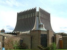 | Our Lady Help of Christians Church, Tile Cross Our Lady Help of Christians is a Grade II* listed catholic church in Tile Cross, Birmingham. Built in 1966 and designed by Richard Gilbert Scott of Giles Scott, Son and Partner. The nearby Our Lady’s Catholic Primary School is associated with the church. |
Visit Stechford plaques
 4
4
plaques
here Stechford has 4 physical plaques in tourist plaque schemes for you to explore via Walkfo Stechford plaques audio map when visiting. Plaques like National Heritage’s “Blue Plaques” provide visual geo-markers to highlight points-of-interest at the places where they happened – and Walkfo’s AI has researched additional, deeper content when you visit Stechford using the app. Experience the history of a location when Walkfo local tourist guide app triggers audio close to each Stechford plaque. Explore Plaques & History has a complete list of Hartlepool’s plaques & Hartlepool history plaque map.


 Trying to encourage visitors to Stechford?