Welcome to Visit Seighford Places
The Walkfo guide to things to do & explore in Seighford
 Visit Seighford places using Walkfo for free guided tours of the best Seighford places to visit. A unique way to experience Seighford’s places, Walkfo allows you to explore Seighford as you would a museum or art gallery with audio guides.
Visiting Seighford Walkfo Preview
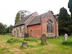
Seighford is a village and civil parish about 3 miles west of Stafford in Staffordshire. The population of this civil parish at the 2011 census was 1,793. The village has a red brick Church of England parish church, St Chad’s, and a 16th-century Tudor mansion. When you visit Seighford, Walkfo brings Seighford places to life as you travel by foot, bike, bus or car with a mobile phone & headphones.
Seighford Places Overview: History, Culture & Facts about Seighford
Visit Seighford – Walkfo’s stats for the places to visit
 With 17 audio plaques & Seighford places for you to explore in the Seighford area, Walkfo is the world’s largest heritage & history digital plaque provider. The AI continually learns & refines facts about the best Seighford places to visit from travel & tourism authorities (like Wikipedia), converting history into an interactive audio experience.
Seighford history
Seighford is a scattered village above a small brook which flows east from Latford pool to the River Sow. Its parish contains the hamlets of Aston, Doxey, and Derrington, from one to one and a half miles east, Coton Clanford, and Great and Little Bridgeford.
Why visit Seighford with Walkfo Travel Guide App?
 You can visit Seighford places with Walkfo Seighford to hear history at Seighford’s places whilst walking around using the free digital tour app. Walkfo Seighford has 17 places to visit in our interactive Seighford map, with amazing history, culture & travel facts you can explore the same way you would at a museum or art gallery with information audio headset. With Walkfo, you can travel by foot, bike or bus throughout Seighford, being in the moment, without digital distraction or limits to a specific walking route. Our historic audio walks, National Trust interactive audio experiences, digital tour guides for English Heritage locations are available at Seighford places, with a AI tour guide to help you get the best from a visit to Seighford & the surrounding areas.
“Curated content for millions of locations across the UK, with 17 audio facts unique to Seighford places in an interactive Seighford map you can explore.”
Walkfo: Visit Seighford Places Map
17 tourist, history, culture & geography spots
Seighford historic spots | Seighford tourist destinations | Seighford plaques | Seighford geographic features |
| Walkfo Seighford tourism map key: places to see & visit like National Trust sites, Blue Plaques, English Heritage locations & top tourist destinations in Seighford | |||
Best Seighford places to visit
Seighford has places to explore by foot, bike or bus. Below are a selection of the varied Seighford’s destinations you can visit with additional content available at the Walkfo Seighford’s information audio spots:
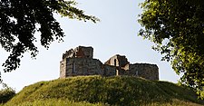
Stafford Castle
Stafford Castle was the seat of the powerful Anglo-Norman Stafford family. The 14th-century stone keep was demolished in 1643, during the Civil War, having been held for the Royalists by Lady Isabel Stafford. The castle was remodeled in the early 19th century by the Jerningham family.

Berry Ring
Berry Ring (also known as Bury Ring) is an Iron Age hillfort in Staffordshire. It is located two miles southwest of the county town of Stafford and half a mile to the west of the M6 motorway.

Doxey Marshes
Doxey Marshes is a 150 hectares (370 acres) nature reserve located within two miles of Stafford town centre. It is particularly noted for its populations of breeding snipe, lapwing, little ringed plover, otter and water shrew. The habitat is one of the most threatened nationally.
Seighford
Seighford is a village and civil parish about 3 miles west of Stafford in Staffordshire. The population of this civil parish at the 2011 census was 1,793. The village has a red brick Church of England parish church, St Chad’s, and a 16th-century Tudor mansion.
Ranton, Staffordshire
Ranton is a small hamlet in Staffordshire, England, situated 3.5 miles (5.6 km) west of Stafford. The population taken at the 2011 census was 382. As of 2013 both public houses that once operated in Ranton were bought and subsequently removed from operation.

Abbey House, Ranton
Abbey House is an early 19th-century ruined stately home in Ranton, Staffordshire, England. Abbey House was built in the 18th century and is now in ruins.
Visit Seighford plaques
 0
0
plaques
here Seighford has 0 physical plaques in tourist plaque schemes for you to explore via Walkfo Seighford plaques audio map when visiting. Plaques like National Heritage’s “Blue Plaques” provide visual geo-markers to highlight points-of-interest at the places where they happened – and Walkfo’s AI has researched additional, deeper content when you visit Seighford using the app. Experience the history of a location when Walkfo local tourist guide app triggers audio close to each Seighford plaque. Currently No Physical Plaques.


 Trying to encourage visitors to Seighford?