Welcome to Visit Radyr Places
The Walkfo guide to things to do & explore in Radyr
 Visit Radyr places using Walkfo for free guided tours of the best Radyr places to visit. A unique way to experience Radyr’s places, Walkfo allows you to explore Radyr as you would a museum or art gallery with audio guides.
Visiting Radyr Walkfo Preview
Radyr (Welsh: Radur) is an outer suburb of Cardiff, about 4 miles (6.4 km) northwest of Cardiff city centre. It is part of Radyr and Morganstown Community, for which the 2011 Census recorded a population of 6,417. When you visit Radyr, Walkfo brings Radyr places to life as you travel by foot, bike, bus or car with a mobile phone & headphones.
Radyr Places Overview: History, Culture & Facts about Radyr
Visit Radyr – Walkfo’s stats for the places to visit
With 81 audio plaques & Radyr places for you to explore in the Radyr area, Walkfo is the world’s largest heritage & history digital plaque provider. The AI continually learns & refines facts about the best Radyr places to visit from travel & tourism authorities (like Wikipedia), converting history into an interactive audio experience.
Radyr history
Stone Age until the Norman Conquest
Radyr developed after the Norman invasion of Wales at the start of the 12th century. It formed part of the Welsh Lordship or cantref of Miskin under the Lordship of Glamorgan created by the Norman King, William Rufus, in 1093.
Origin of the name
Lifris’s Life of St Cadog mentions a croft or tref on the site called Aradur Hen. Lifris also tells the story of Tylyway, a religious hermit who was held to have lived on the banks of the Taff. The name Radyr is from the Welsh yr adur, meaning “the chantry”
Norman occupation and Middle Ages

Norman motte in the “mound field” is a flat-topped mound 30 metres (100 ft) in diameter at the base and 3.8 metres (12 ft) high. The early settlement that became Radyr developed around the Norman church and manor house in what is now Danescourt.
Mathew family

In 1469 Thomas Mathew (died 1469), the third or fourth son of Sir David Mathew of Llandaf, inherited the land by marriage to Catherine, heiress of Radyr. He built Radyr Court, a manor house on the site of what is now the Radyr Inn in Danescourt. On Thomas’ death, his lands passed to his eldest son David and then to his younger son William Mathew. His successor was Sir George Mathew, who became MP for Glamorganshire and Sheriff of Glamorgan. He had 24 children, eight of whom were illegitimate.
Stuart period
Radyr was bought by Sir Edward Lewis, who was knighted by James I. He owned St Fagans Castle and its surrounding lands, scene of the Battle of St Faggans in the English Civil War. The Lewis fortune passed to Elizabeth Lewis who married Other Windsor, 3rd Earl of Plymouth.
Development from the 18th century
Many residents of Radyr worked in the Melingriffith Tin Plate Works, on the other side of the River Taff in Whitchurch. The works opened in 1749 and closed in 1957. Until the mid 19th century Radyr was a collection of small farms, crofts and cottages. After Radyr railway station opened in 1863, the population rose from 400 to 600 in 20 years.
Wartime

In the First World War the community raised funds for a “Radyr bed” at the nearby Welsh Metropolitan Military Hospital. In the Second World War thousands of children were evacuated from metropolitan areas such as London, Birmingham and Liverpool.
Post-war history
Radyr was officially incorporated as a suburb of Cardiff in 1974. A new development, the Danescourt estate, was built on land surrounding Radyr Court and St John the Baptist parish church. Danybryn Woods, near the development, was retained as the entire forest is protected by a tree preservation order.
Radyr geography / climate
Geological structure
Radyr Stone is a Triassic breccia used widely for decorative work in Cardiff area, including Llandaff Cathedral, Cardiff Docks and in the bridges of the Taff Vale Railway. The bedrock under the whole area is predominantly sandstone, dating from both the Devonian period and the Triassic (New Red Sandstone) laid down in arid conditions.
Radyr Weir

Radyr Weir was built in 1774 to divert water into a leat to the Melingriffith Tin Plate Works. Salmon and sea trout stocks in the Taff have been recovering from nearly 200 years of industrial pollution and exploitation. In 1993 over 500 salmon and 700 sea trout returned to the river to spawn.
Radyr Woods Nature Area

Radyr Woods is a Site of Nature Conservation Importance and the adjoining Hermit Woods is also a Local Nature Reserve. The community nature reserve covers 14 acres (6 ha) It has a network of footpaths and boardwalks.
Radyr hawkweed
Radyr hawkweed is the common name of Hieracium radyrense, a very rare endemic member of the aster, daisy, or sunflower family. It was first identified in 1907 at the quarry, was described as a variety in 1948 and then as a separate species in 1955. Today only a single population of about 25 plants survives in the wild.
Why visit Radyr with Walkfo Travel Guide App?
 You can visit Radyr places with Walkfo Radyr to hear history at Radyr’s places whilst walking around using the free digital tour app. Walkfo Radyr has 81 places to visit in our interactive Radyr map, with amazing history, culture & travel facts you can explore the same way you would at a museum or art gallery with information audio headset. With Walkfo, you can travel by foot, bike or bus throughout Radyr, being in the moment, without digital distraction or limits to a specific walking route. Our historic audio walks, National Trust interactive audio experiences, digital tour guides for English Heritage locations are available at Radyr places, with a AI tour guide to help you get the best from a visit to Radyr & the surrounding areas.
“Curated content for millions of locations across the UK, with 81 audio facts unique to Radyr places in an interactive Radyr map you can explore.”
Walkfo: Visit Radyr Places Map
81 tourist, history, culture & geography spots
Radyr historic spots | Radyr tourist destinations | Radyr plaques | Radyr geographic features |
| Walkfo Radyr tourism map key: places to see & visit like National Trust sites, Blue Plaques, English Heritage locations & top tourist destinations in Radyr | |||
Best Radyr places to visit
Radyr has places to explore by foot, bike or bus. Below are a selection of the varied Radyr’s destinations you can visit with additional content available at the Walkfo Radyr’s information audio spots:
 | Radyr Golf Club Radyr Golf Club is a golf course in Radyr, northwestern Cardiff, Wales. It is the oldest existing golf club in Cardiff. It was established on 29 November 1902, following the breakup of Lisvane Golf Club, the preceding year. |
 | Prince of Wales Orthopaedic Hospital, Rhydlafar Prince of Wales Orthopaedic Hospital (Welsh: Tywysog Ysbyty Orthopedig Cymru) was a specialist hospital in Rhydlafar, Cardiff, Wales. |
 | Coryton, Cardiff Coryton is a district of Cardiff, the capital city of Wales. It lies immediately to the north of Whitchurch next to junction 32 of the M4 motorway. It is within the Whitchedurch & Tongwynlais electoral ward. |
 | Pentyrch Pentyrch (Welsh: Pen-tyrch) is a village and community located on the western outskirts of Cardiff, Wales. The community includes the neighbouring village of Creigiau and Gwaelod y Garth. On 26 February 2016, multiple witnesses reported seeing UFOs. |
| Coryton railway station Coryton is the terminus of the Coryton Line 5 miles (8.0 km) north of Cardiff Central via Cardiff Queen Street. Passenger services are provided by Transport for Wales as part of the Valley Lines network. |
 | Craig-y-parc House Craig-y-parc House is a Grade II* listed building in Pentyrch, Cardiff, Wales. It was built for Thomas Evans, a colliery owner, by Charles Edward Mallows. The house now operates as a residential school for children and young adults with disabilities. |
 | Risca United F.C. Risca United Association Football Club is a football club based in South Wales. The team play in the Cymru South, playing in the Welsh Premier League. |
 | Pentrebane Pentrebane (Welsh: Pentre-Baen) is a district in the west of Cardiff, capital of Wales. It is part of the Fairwater community. |
 | Taff’s Well Thermal Spring Taff’s Well thermal spring is located north of Cardiff, South Wales. It is the only thermal spring in Wales. The spring is enclosed inside a well and stone building constructed in the 19th century. |
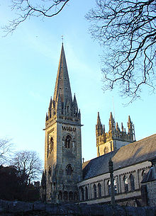 | Diocese of Llandaff Diocese of Llandaff traces its roots to pre-Reformation times as heir of a Catholic bishopric. It currently covers most of the former Welsh county of Glamorgan, but once stretched from the River Towy to the middle of the Wye Valley. |
Visit Radyr plaques
 6
6
plaques
here Radyr has 6 physical plaques in tourist plaque schemes for you to explore via Walkfo Radyr plaques audio map when visiting. Plaques like National Heritage’s “Blue Plaques” provide visual geo-markers to highlight points-of-interest at the places where they happened – and Walkfo’s AI has researched additional, deeper content when you visit Radyr using the app. Experience the history of a location when Walkfo local tourist guide app triggers audio close to each Radyr plaque. Explore Plaques & History has a complete list of Hartlepool’s plaques & Hartlepool history plaque map.


 Trying to encourage visitors to Radyr?