Welcome to Visit Pwll Places The Walkfo guide to things to do & explore in Pwll
Visit Pwll places using Walkfo for free guided tours of the best Pwll places to visit. A unique way to experience Pwll’s places, Walkfo allows you to explore Pwll as you would a museum or art gallery with audio guides.
Visiting Pwll Walkfo Preview Pwll is a small coastal village located between Llanelli and Burry Port. It has a local shop, pet shop, Post Office located in The Blue Anchor. The area is also where the Millennium Coastal Path runs through. When you visit Pwll, Walkfo brings Pwll places to life as you travel by foot, bike, bus or car with a mobile phone & headphones.
Pwll Places Overview: History, Culture & Facts about Pwll
Visit Pwll – Walkfo’s stats for the places to visit
With 36 audio plaques & Pwll places for you to explore in the Pwll area, Walkfo is the world’s largest heritage & history digital plaque provider. The AI continually learns & refines facts about the best Pwll places to visit from travel & tourism authorities (like Wikipedia), converting history into an interactive audio experience.
Why visit Pwll with Walkfo Travel Guide App?
You can visit Pwll places with Walkfo Pwll to hear history at Pwll’s places whilst walking around using the free digital tour app. Walkfo Pwll has 36 places to visit in our interactive Pwll map, with amazing history, culture & travel facts you can explore the same way you would at a museum or art gallery with information audio headset. With Walkfo, you can travel by foot, bike or bus throughout Pwll, being in the moment, without digital distraction or limits to a specific walking route. Our historic audio walks, National Trust interactive audio experiences, digital tour guides for English Heritage locations are available at Pwll places, with a AI tour guide to help you get the best from a visit to Pwll & the surrounding areas.
“Curated content for millions of locations across the UK, with 36 audio facts unique to Pwll places in an interactive Pwll map you can explore.”
Walkfo Pwll tourism map key: places to see & visit like National Trust sites, Blue Plaques, English Heritage locations & top tourist destinations in Pwll
Best Pwll places to visit
Pwll has places to explore by foot, bike or bus. Below are a selection of the varied Pwll’s destinations you can visit with additional content available at the Walkfo Pwll’s information audio spots:
Llanelly power station Llanelly power station supplied electricity to the town of Llanelli (Llanelli since 1966) from 1910 to the late 1960s. The power station was redeveloped in the 1920s to meet the increased demand for electricity.
Hall Street Methodist Church, Llanelli The present building was built in 1856 and is located in Hall Street, Llanelli, Carmarthenshire. The chapel was designated as a Grade II listed building in December 1992.
Stradey Park Stradey Park (Welsh: Parc y Strade) was a rugby union stadium. It was the home of the Scarlets region and Llanelli RFC rugby teams. The stadium was demolished in 2010 and has since been replaced with housing.
St Ellyw’s Church, Llanelli St Elli Church, also called St Ellyw’s Church, is an Anglican parish church in Llanelli, Carmarthenshire, Wales, dedicated to Saint Elli. It was built in the medieval period, possibly in the 15th century, and is located in Bridge Street, opposite Llanelly House.
Tabernacle Chapel, Llanelli Tabernacle Chapel is an Independent (Congregational) chapel in Llanelli, Carmarthenshire, Wales. It was built in 1872 and is located at 17 Cowell Street. The chapel was designed by John Humphrey and is a Grade II* listed building. The Royal Commission on the Ancient and Historical Monuments of Wales curates the archaeological, architectural and historic records.
Park Congregational Chapel, Llanelli Park Congregational Chapel was built in 1864 and is located in Llanelli, Carmarthenshire. It was designated as a Grade II listed building on 3 December 1992.
Llanelli transmitting station The Llanelli transmitting station was originally built by the BBC. It entered service in mid 1970 transmitting the now-defunct 405-line VHF television system. UHF colour television was added to the mast in early 1975.
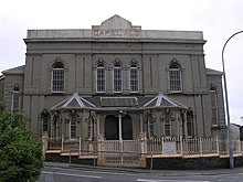
Capel Als, Llanelli Capel Als is an Independent (Congregational) chapel in Llanelli, Carmarthenshire. It is regarded as one of the most significant religious buildings in Wales. Folk tradition suggested that the name refers to a woman named Als, which along with Alys is the Welsh equivalent of the English name Alice.
Calfaria Baptist Chapel, Llanelli Calfaria was one of the many Baptist chapels in Llanelli, Carmarthenshire, Wales. Established in 1881, the original chapel was a modest red-brick building which cost £500. It flourished for over a century before closing in the early twenty-first century.
Myrtle House Myrtle House is an Elim Pentecostal Church in Llanelli, Wales. The church was started in 1935 as a result of the actions of P.S. Brewster.
Visit Pwll plaques
8 plaques herePwll has 8 physical plaques in tourist plaque schemes for you to explore via Walkfo Pwll plaques audio map when visiting. Plaques like National Heritage’s “Blue Plaques” provide visual geo-markers to highlight points-of-interest at the places where they happened – and Walkfo’s AI has researched additional, deeper content when you visit Pwll using the app. Experience the history of a location when Walkfo local tourist guide app triggers audio close to each Pwll plaque. Explore Plaques & History has a complete list of Hartlepool’s plaques & Hartlepool history plaque map.
Experience Pwll audio walks & tours
Walkfo guides for things to do / places to visit in Pwll allows exploration as you would do an art gallery or museum. Walk close to one of Pwll’s 36 historic places & our digital tour guide will create an audio story for that spot. With headphone connected, you can explore Pwll freely by foot, bike or bus – with your own personal tour guide in your pocket.
Explore Pwll Map App
Our visit Pwll map shows you things-to-do & places you can visit in Pwll & surrounding areas using the Walkfo digital audio tour guide app. Each spot has plaque, building, street or area information on history, culture or tourism.
You can set your Walkfo’s Pwll tourist map to find historic & tourism spots within 1km, 3km & 5km of the Pwll centre, depending on how far you plan to explore whilst you visit Pwll area at LONG:-4.209093, LAT:51.687589.
Walkfo App
Walkfo
Walkfo is free to download & use (for a limited time period), so if you are looking to explore Pwll, go to your App Store to search for “Walkfo” or follow a links below and install on your mobile phone. Walkfo is designed for use with headphones or AirPods, so you can walk & explore whilst learning about the things around you without digital distraction.
● Furnace, Carmarthenshire ● Parc Howard Museum ● Stradey Park Cricket Ground ● Church of All Saints, Llanelli ● Stradey Park ● Llanelli ● St Ellyw’s Church, Llanelli ● Stradey ● Llanelly House ● Tabernacle Chapel, Llanelli ● Zion Baptist Chapel, Llanelli ● Llanelli Town Hall ● Sandy, Carmarthenshire ● 97.5 Scarlet FM ● Park Congregational Chapel, Llanelli ● Ebenezer, Llanelli ● District of Llanelli ● Capel Als, Llanelli ● Calfaria Baptist Chapel, Llanelli ● Myrtle House ● Coleg Sir Gâr ● Cwmbach, Carmarthenshire ● Soar, Llanelli ● North Dock, Llanelli ● Bethel Baptist Chapel, Llanelli ● Millennium Coastal Park ● Millennium Coastal Path ● Trimsaran ● Carmarthen Bay Power Station ● Burry Port
● Burry Port Lifeboat Station ● Glanymor ● Burry Port Lighthouse ● Pembrey and Burry Port Town
Getting to / around Pwll – transport link, station & street map
Getting around in Pwll using public transportation may include road, street, train, underground, bus or tram transport options. Walkfo has identified the following Pwll places with historic / cultural / factual content when you visit:
Local Pwll Public Transport Stations
Pwll Notable Streets & Road Destinations
Llanelly power station
Llanelli transmitting station
Llanelli railway station
Pembrey and Burry Port railway station
Burry Port railway station
Burry Port television relay station
Hall Street Methodist Church, Llanelli
A4214 road
[transportsummary]
Local Pwll historians & Pwll tour guides
Trying to encourage visitors to Pwll? Walkfo has millions audio places already available but Walkfo Creator gives Pwll’s places, attractions & landmarks ability to create their own unique outdoor audio museums & using our simple & easy to use Walkfo Creator. – Creating a new audio experience for your Pwll place is free* and quick (15+ minutes if you prepare text content) to use, with Walkfo Creator doing the hard work of generating AI audio files for geo-spots from the text you provide with a simply click on a map. – The 100 Amazing Pwll Places is just one example of an outdoor museum created using Walkfo Creator (pictured to the left) for people to safely explore during Covid-19 times whilst visiting a city. Our tool is open to tourism organisations, travel destinations & National Trust locations to create their own audio walks to offer free when people visit Pwll destinations. – Walkfo itself is looking to partner with websites offering things-to-do / what’s on events listings to enhance the content of our ‘visit-Pwll’ web pages (for example: www.visitPwll.com). If you are interested in partnering, please contact us to discuss options.
* Walkfo Creator is free to use for a limited number of audio spots within a map with a license fee applicable when more than 20 audio spots within location walk are created. v1.1336
 Visit Pwll places using Walkfo for free guided tours of the best Pwll places to visit. A unique way to experience Pwll’s places, Walkfo allows you to explore Pwll as you would a museum or art gallery with audio guides.
 You can visit Pwll places with Walkfo Pwll to hear history at Pwll’s places whilst walking around using the free digital tour app. Walkfo Pwll has 36 places to visit in our interactive Pwll map, with amazing history, culture & travel facts you can explore the same way you would at a museum or art gallery with information audio headset. With Walkfo, you can travel by foot, bike or bus throughout Pwll, being in the moment, without digital distraction or limits to a specific walking route. Our historic audio walks, National Trust interactive audio experiences, digital tour guides for English Heritage locations are available at Pwll places, with a AI tour guide to help you get the best from a visit to Pwll & the surrounding areas.


 8
8


 Trying to encourage visitors to Pwll?