Welcome to Visit Porthmadog Places
The Walkfo guide to things to do & explore in Porthmadog
 Visit Porthmadog places using Walkfo for free guided tours of the best Porthmadog places to visit. A unique way to experience Porthmadog’s places, Walkfo allows you to explore Porthmadog as you would a museum or art gallery with audio guides.
Visiting Porthmadog Walkfo Preview
Porthmadog is a coastal town and community in the Eifionydd area of Gwynedd and the historic county of Caernarfonshire . It grew in the 19th century as a port for local slate, but as the trade declined, it continued as a shopping and tourism centre . The 1987 National Eisteddfod was held there . When you visit Porthmadog, Walkfo brings Porthmadog places to life as you travel by foot, bike, bus or car with a mobile phone & headphones.
Porthmadog Places Overview: History, Culture & Facts about Porthmadog
Visit Porthmadog – Walkfo’s stats for the places to visit
With 26 audio plaques & Porthmadog places for you to explore in the Porthmadog area, Walkfo is the world’s largest heritage & history digital plaque provider. The AI continually learns & refines facts about the best Porthmadog places to visit from travel & tourism authorities (like Wikipedia), converting history into an interactive audio experience.
Porthmadog history
Porthmadog came about after William Madocks built a sea wall, the Cob, in 1808–1811 to reclaim much of Traeth Mawr from the sea for farming use. Diversion of the Afon Glaslyn caused it to scour out a new natural harbour deep enough for small ocean-going sailing ships. Quarry companies followed, with wharves along the shore almost to Borth-y-Gest.
Porthmadog culture & places
Porthmadog is a mainly Welsh-speaking community. 74.9 per cent of the inhabitants speak Welsh regularly. The highest proportion of Welsh speakers is in the 10–14 age range at 96.3 per cent.
Porthmadog etymology
The name Porthmadog derives from its English spelling, Portmadoc, which was a conjunction of Port and Madocks. Some believe it is named after a folklore character, Madog ab Owain Gwynedd, whose name appears also in “Ynys Fadog”
Porthmadog landmarks

The Cob is a prominent embankment built across the Glaslyn estuary in 1811 by William Madocks to reclaim land at Traeth Mawr for agriculture. It opened with a four-day feast and Eisteddfod celebrating the roadway connecting Caernarfonshire to Meirionnydd, which figured in Madocks’s plans for a road from London to his proposed port at Porthdinllaen. The former tollhouse at the north-western end of the Cob has slate-clad walls. In 1927 the Cob was breached again and took several months to repair.
Porthmadog geography / climate
Porthmadog lies in Eifionydd, on the estuary of the Afon Glaslyn, where it runs into Tremadog Bay. Oystercatchers, redshanks and curlews are common, as are summer flocks of sandwich terns. The town’s temperate maritime climate is influenced by the Gulf Stream.
Villages
Borth-y-Gest, 1 mile (1.6 km) south of Porthmadog, is built in a shallow bowl sweeping down to a sheltered bay . Stryd Mersey leads up from the bay flanked by terraced cottages . Parc y Borth is a local nature reserve in deciduous woodland dominated by ancient Welsh oaks . Morfa Bychan has a wide beach, Black Rock Sands, with Graig Ddu, a rocky headland at its western end .
Why visit Porthmadog with Walkfo Travel Guide App?
 You can visit Porthmadog places with Walkfo Porthmadog to hear history at Porthmadog’s places whilst walking around using the free digital tour app. Walkfo Porthmadog has 26 places to visit in our interactive Porthmadog map, with amazing history, culture & travel facts you can explore the same way you would at a museum or art gallery with information audio headset. With Walkfo, you can travel by foot, bike or bus throughout Porthmadog, being in the moment, without digital distraction or limits to a specific walking route. Our historic audio walks, National Trust interactive audio experiences, digital tour guides for English Heritage locations are available at Porthmadog places, with a AI tour guide to help you get the best from a visit to Porthmadog & the surrounding areas.
“Curated content for millions of locations across the UK, with 26 audio facts unique to Porthmadog places in an interactive Porthmadog map you can explore.”
Walkfo: Visit Porthmadog Places Map
26 tourist, history, culture & geography spots
Porthmadog historic spots | Porthmadog tourist destinations | Porthmadog plaques | Porthmadog geographic features |
| Walkfo Porthmadog tourism map key: places to see & visit like National Trust sites, Blue Plaques, English Heritage locations & top tourist destinations in Porthmadog | |||
Best Porthmadog places to visit
Porthmadog has places to explore by foot, bike or bus. Below are a selection of the varied Porthmadog’s destinations you can visit with additional content available at the Walkfo Porthmadog’s information audio spots:

Peniel Chapel
Peniel Chapel (Welsh: Capel Peniel) is a former Calvinistic Methodist chapel in Tremadog, Gwynedd . It is one of five Grade I-listed nonconformist chapels in Wales .

Ysbyty Alltwen
Ysbyty Alltwen is a health facility in Tremadog, Gwynedd, Wales . It is managed by the Betsi Cadwaladr University Health Board .

Moel y Gest
Moel y Gest is a 263 m (863 ft) hill to the west of Porthmadog in North Wales . It is a very rocky hill with high topographic prominence because of the lower land that surrounds it on all sides . The views from the top are far ranging and include the Llŷn Peninsula, the Rhinogydd, Moelwynion, and Snowdon .

Festival N°6
Festival N°6 (Festival Number 6) is an annual art and music festival held in and around Portmeirion, North Wales. The festival presents a wide range of music genres across multiple stages. In July 2018 the festival organisers announced that the festival would be taking an indefinite break.
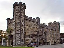
Castell Deudraeth
Castell Deudraeth is a former manor house approximately 2 km NE of Portmeirion in Gwynedd, North Wales.

Ysbyty Bron y Garth
Ysbyty Bron y Garth was a health facility in Penrhyndeudraeth, Gwynedd, Wales. It was managed by the Betsi Cadwaladr University Health Board.
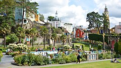
Portmeirion
Portmeirion is a tourist village in Gwynedd, North Wales. It was designed and built by Sir Clough Williams-Ellis between 1925 and 1975 in the style of an Italian village. It has served as the location for numerous films and television shows, most notably as “The Village” in the 1960s television show The Prisoner.
Visit Porthmadog plaques
 6
6
plaques
here Porthmadog has 6 physical plaques in tourist plaque schemes for you to explore via Walkfo Porthmadog plaques audio map when visiting. Plaques like National Heritage’s “Blue Plaques” provide visual geo-markers to highlight points-of-interest at the places where they happened – and Walkfo’s AI has researched additional, deeper content when you visit Porthmadog using the app. Experience the history of a location when Walkfo local tourist guide app triggers audio close to each Porthmadog plaque. Explore Plaques & History has a complete list of Hartlepool’s plaques & Hartlepool history plaque map.


 Trying to encourage visitors to Porthmadog?