Welcome to Visit Podsmead Places The Walkfo guide to things to do & explore in Podsmead
Visit Podsmead places using Walkfo for free guided tours of the best Podsmead places to visit. A unique way to experience Podsmead’s places, Walkfo allows you to explore Podsmead as you would a museum or art gallery with audio guides.
Visiting Podsmead Walkfo Preview Podsmead is one mile from the historic city centre. The population of this Gloucester Ward was 2,994 at the 2011 Census. It is close to the hamlet of Hempsted. When you visit Podsmead, Walkfo brings Podsmead places to life as you travel by foot, bike, bus or car with a mobile phone & headphones.
Podsmead Places Overview: History, Culture & Facts about Podsmead
Visit Podsmead – Walkfo’s stats for the places to visit
With 120 audio plaques & Podsmead places for you to explore in the Podsmead area, Walkfo is the world’s largest heritage & history digital plaque provider. The AI continually learns & refines facts about the best Podsmead places to visit from travel & tourism authorities (like Wikipedia), converting history into an interactive audio experience.
Podsmead history
Podsmead was largely built during the 20th century. The larger, grander houses similar to those in parts of Tuffley were built in the interwar period. Immediately after World War II an estate of temporary homes and social housing was built.
Why visit Podsmead with Walkfo Travel Guide App?
You can visit Podsmead places with Walkfo Podsmead to hear history at Podsmead’s places whilst walking around using the free digital tour app. Walkfo Podsmead has 120 places to visit in our interactive Podsmead map, with amazing history, culture & travel facts you can explore the same way you would at a museum or art gallery with information audio headset. With Walkfo, you can travel by foot, bike or bus throughout Podsmead, being in the moment, without digital distraction or limits to a specific walking route. Our historic audio walks, National Trust interactive audio experiences, digital tour guides for English Heritage locations are available at Podsmead places, with a AI tour guide to help you get the best from a visit to Podsmead & the surrounding areas.
“Curated content for millions of locations across the UK, with 120 audio facts unique to Podsmead places in an interactive Podsmead map you can explore.”
Walkfo Podsmead tourism map key: places to see & visit like National Trust sites, Blue Plaques, English Heritage locations & top tourist destinations in Podsmead
Best Podsmead places to visit
Podsmead has places to explore by foot, bike or bus. Below are a selection of the varied Podsmead’s destinations you can visit with additional content available at the Walkfo Podsmead’s information audio spots:
Matson, Gloucester Matson is a suburb in the City of Gloucester, Gloucestershire, England. It is located on the outskirts of the city centre.
Tredworth Road Cemetery Tredworth Road Cemetery, sometimes known as Gloucester Old Cemetery, is a cemetery in Gloucester, England. It contains over 250 war graves maintained by the Commonwealth War Graves Commission. The cemetery chapel is a grade II listed building.
Coney Hill Hospital Coney Hill Hospital was a mental health facility in Gloucester, England. It was located on the outskirts of Gloucester in the 1960s and 1960s.
St Barnabas Church, Gloucester St Barnabas Church is a Grade II listed building in Gloucester, Gloucestershire. It was built in 1938–40 and obtained its Grade II status on 9 March 1982. The church’s denomination is the Church of England.
Robin’s Wood Hill Quarry Robin’s Wood Hill Quarry (grid reference SO836148) is a 1.67-hectare (4.1-acre) geological Site of Special Scientific Interest in Gloucestershire, on Robinswood Hill.
St Paul and St Stephen’s Church, Gloucester St Paul and St Stephen’s Church is a Church of England church located in Stroud Road, Gloucester, Gloucestershire. St Paul’s church was built between 1882 and 1883 and closed in 2010.
Podsmead Podsmead is one mile from the historic city centre. The population of this Gloucester Ward was 2,994 at the 2011 Census. It is close to the hamlet of Hempsted.
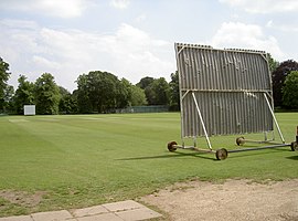
Spa Ground Spa Ground is a cricket ground in Gloucester, Gloucestershire. The first recorded match on the ground was in 1867, when Gloucester played an All-England Eleven.
Range Farm Fields Range Farm Fields (grid reference SO850130) is a 12.8-hectare (32-acre) biological Site of Special Scientific Interest in Gloucestershire, near to Gloucester City, notified in 1996.
Bristol Road Bristol Road dates from the medieval period. It runs between Southgate Street in the north and Quedgeley in the south. It contains a number of listed buildings and other notable structures.
Visit Podsmead plaques
19 plaques herePodsmead has 19 physical plaques in tourist plaque schemes for you to explore via Walkfo Podsmead plaques audio map when visiting. Plaques like National Heritage’s “Blue Plaques” provide visual geo-markers to highlight points-of-interest at the places where they happened – and Walkfo’s AI has researched additional, deeper content when you visit Podsmead using the app. Experience the history of a location when Walkfo local tourist guide app triggers audio close to each Podsmead plaque. Explore Plaques & History has a complete list of Hartlepool’s plaques & Hartlepool history plaque map.
Experience Podsmead audio walks & tours
Walkfo guides for things to do / places to visit in Podsmead allows exploration as you would do an art gallery or museum. Walk close to one of Podsmead’s 120 historic places & our digital tour guide will create an audio story for that spot. With headphone connected, you can explore Podsmead freely by foot, bike or bus – with your own personal tour guide in your pocket.
Explore Podsmead Map App
Our visit Podsmead map shows you things-to-do & places you can visit in Podsmead & surrounding areas using the Walkfo digital audio tour guide app. Each spot has plaque, building, street or area information on history, culture or tourism.
You can set your Walkfo’s Podsmead tourist map to find historic & tourism spots within 1km, 3km & 5km of the Podsmead centre, depending on how far you plan to explore whilst you visit Podsmead area at LONG:-2.2555555555556, LAT:51.841666666667.
Walkfo App
Walkfo
Walkfo is free to download & use (for a limited time period), so if you are looking to explore Podsmead, go to your App Store to search for “Walkfo” or follow a links below and install on your mobile phone. Walkfo is designed for use with headphones or AirPods, so you can walk & explore whilst learning about the things around you without digital distraction.
Things to do & visit in Podsmead / surrounding areas
● Hunts Grove ● Kingsway Village ● Hardwicke, Stroud ● Quedgeley ● St James Church, Quedgeley ● The Little Thatch ● St Margaret’s Church, Whaddon ● St Swithun’s Church, Brookthorpe ● St George’s Church, Gloucester ● Brookthorpe-with-Whaddon ● Brookthorpe ● Tuffley ● Matson, Gloucester ● Gloucestershire Wildlife Trust ● Robinswood Hill ● White City, Gloucester ● Coney Hill Hospital ● St Barnabas Church, Gloucester ● Robin’s Wood Hill Quarry ● Barton and Tredworth ● Wagon Works Ground ● Gloucester FM ● Moreland, Gloucester ● St Paul and St Stephen’s Church, Gloucester ● Podsmead ● Gloucester Services ● Gloucester TMD ● Gloucester Leisure Centre ● Spa Ground ● Norfolk Buildings
● Range Farm Fields ● Gloucester Park, Gloucester ● Gloucestershire Royal Hospital ● Gloucester First Spiritualist Church ● Tuffley Rovers F.C. ● Elmbridge, Gloucester ● Brunswick Square, Gloucester ● Gloucester National Spiritualist Church ● Wotton, Gloucester ● Hillfield Gardens, Gloucester ● Hillfield House ● Wellington Parade ● Whitefriars, Gloucester ● Northgate House, Gloucester ● Gloucester Transport Hub ● St Peter’s Church, Gloucester ● Gloucestershire Archives ● Kings Square, Gloucester ● Clapham, Gloucester ● Kingsholm Stadium ● Tanners Hall ● 12–18 Brunswick Square, Gloucester ● Church of St. Luke, Gloucester ● Gloucester Public Library ● Gloucester Quays ● Museum of Gloucester ● Winston Hall ● Siege of Gloucester ● Greyfriars, Gloucester ● Gloucester ● Gloucester Castle ● St Owen’s Church, Gloucester ● Gloucestershire Royal Infirmary ● St Kyneburgh’s Chapel, Gloucester ● Kings Walk Shopping Centre ● St Mary de Crypt Church, Gloucester ● Marylone, Gloucester ● High Orchard Bridge ● High Orchard ● Gloucester Docks ● Eastgate Shopping Centre, Gloucester ● Gloucester Guildhall ● Gloucester Waterways Museum ● Robert Raikes’ House ● Blackfriars, Gloucester ● The New Inn, Gloucester ● St Michael’s Tower, Gloucester ● Soldiers of Gloucestershire Museum ● Mercers Hall, Gloucester ● Llanthony Secunda Priory ● Ladybellegate House ● Fleece Hotel ● Theatre Royal, Gloucester ● Bearland House ● The Sword (public house) ● The Fountain Inn, Gloucester ● Gloucester Crown Court ● Gloucester Shire Hall ● HM Prison Gloucester ● Gloucester Court of Probate ● Diocese of Gloucester ● King Edward’s Gate ● Westgate, Gloucester ● Gloucester Abbey ● Glevum ● Gloucester Rural District ● Old Crown Inn ● Dick Whittington Tavern ● Hyatt House, Gloucester ● The Folk of Gloucester ● Lower George Hotel ● Hempsted Court ● Meadow Park, Gloucester ● St Mary de Lode Church, Gloucester ● St Nicholas Church, Gloucester ● St Oswald’s Priory, Gloucester ● Hempsted ● Westgate Galleria ● Castle Meads Power Station ● Archdeacon Meadow ● Gloucester Rowing Club ● Our Lady’s Well, Hempsted ● Over Bridge ● Over, Gloucestershire ● Herefordshire and Gloucestershire Canal Trust ● Elmore, Gloucestershire ● Gloucester Cathedral ● The Tall Ship Public House
Getting to / around Podsmead – transport link, station & street map
Getting around in Podsmead using public transportation may include road, street, train, underground, bus or tram transport options. Walkfo has identified the following Podsmead places with historic / cultural / factual content when you visit:
Local Podsmead Public Transport Stations
Podsmead Notable Streets & Road Destinations
Gloucester Eastgate railway station
Gloucester railway station
Tredworth Road Cemetery
Barton Street, Gloucester
Bristol Road
Horton Road Hospital
Horton Road
Spa Road
Oxford Street, Gloucester
Worcester Street, Gloucester
Southgate Street
9 and 9A Southgate Street, Gloucester
Llanthony Road Bridge
Ladybellegate Street
Commercial Road, Gloucester
Longsmith Street
Northgate Street
66 Westgate Street
333 Stroud Road
Eastgate Street
[transportsummary]
Local Podsmead historians & Podsmead tour guides
Trying to encourage visitors to Podsmead? Walkfo has millions audio places already available but Walkfo Creator gives Podsmead’s places, attractions & landmarks ability to create their own unique outdoor audio museums & using our simple & easy to use Walkfo Creator. – Creating a new audio experience for your Podsmead place is free* and quick (15+ minutes if you prepare text content) to use, with Walkfo Creator doing the hard work of generating AI audio files for geo-spots from the text you provide with a simply click on a map. – The 100 Amazing Podsmead Places is just one example of an outdoor museum created using Walkfo Creator (pictured to the left) for people to safely explore during Covid-19 times whilst visiting a city. Our tool is open to tourism organisations, travel destinations & National Trust locations to create their own audio walks to offer free when people visit Podsmead destinations. – Walkfo itself is looking to partner with websites offering things-to-do / what’s on events listings to enhance the content of our ‘visit-Podsmead’ web pages (for example: www.visitPodsmead.com). If you are interested in partnering, please contact us to discuss options.
* Walkfo Creator is free to use for a limited number of audio spots within a map with a license fee applicable when more than 20 audio spots within location walk are created. v1.1336
 Visit Podsmead places using Walkfo for free guided tours of the best Podsmead places to visit. A unique way to experience Podsmead’s places, Walkfo allows you to explore Podsmead as you would a museum or art gallery with audio guides.
 With 120 audio plaques & Podsmead places for you to explore in the Podsmead area, Walkfo is the world’s largest heritage & history digital plaque provider. The AI continually learns & refines facts about the best Podsmead places to visit from travel & tourism authorities (like Wikipedia), converting history into an interactive audio experience.
 You can visit Podsmead places with Walkfo Podsmead to hear history at Podsmead’s places whilst walking around using the free digital tour app. Walkfo Podsmead has 120 places to visit in our interactive Podsmead map, with amazing history, culture & travel facts you can explore the same way you would at a museum or art gallery with information audio headset. With Walkfo, you can travel by foot, bike or bus throughout Podsmead, being in the moment, without digital distraction or limits to a specific walking route. Our historic audio walks, National Trust interactive audio experiences, digital tour guides for English Heritage locations are available at Podsmead places, with a AI tour guide to help you get the best from a visit to Podsmead & the surrounding areas.


 19
19


 Trying to encourage visitors to Podsmead?