Welcome to Visit Leatherhead Places
The Walkfo guide to things to do & explore in Leatherhead
 Visit Leatherhead places using Walkfo for free guided tours of the best Leatherhead places to visit. A unique way to experience Leatherhead’s places, Walkfo allows you to explore Leatherhead as you would a museum or art gallery with audio guides.
Visiting Leatherhead Walkfo Preview
Leatherhead grew up beside a ford on the River Mole, from which its name is thought to derive. During the late Anglo-Saxon period, Leatherhead was a royal vill and is first mentioned in the will of Alfred the Great in 880 AD. The construction of turnpike roads in the mid-18th century and the arrival of the railways attracted newcomers to the town. Large-scale manufacturing industries arrived following the end of the First World War. When you visit Leatherhead, Walkfo brings Leatherhead places to life as you travel by foot, bike, bus or car with a mobile phone & headphones.
Leatherhead Places Overview: History, Culture & Facts about Leatherhead
Visit Leatherhead – Walkfo’s stats for the places to visit
With 33 audio plaques & Leatherhead places for you to explore in the Leatherhead area, Walkfo is the world’s largest heritage & history digital plaque provider. The AI continually learns & refines facts about the best Leatherhead places to visit from travel & tourism authorities (like Wikipedia), converting history into an interactive audio experience.
Leatherhead history
Early history
The earliest evidence of human activity in Leatherhead comes from the Iron Age. An Anglo-Saxon settlement at Leatherhead was most likely founded on the east side of the River Mole in the 6th century. A second cemetery was discovered in 1984 on the site of the former Goblin factory in Ermyn Way (now the location of the offices of Esso)
Governance
The medieval history of Leatherhead is complex, since the parish was divided into a number of manors. The town appears in Domesday Book of 1086 as Leret and was held by Osbern de Ow as a mesne lord to William I. Its Domesday assets were one church, belonging to Ewell, and 40 acres (160,000 m) of land. It was valued at an annual income of £1. To the south was the manor of Thorncroft, which was held by Richard son of Gilbert as tenant-in-chief. To the north was the manor of Pachesham, subdivided into two parts, each of which was held by a mesne lord to the tenant-in-chief, Bishop Odo of Bayeux. Finally there are sporadic mentions in surviving documents of a manor called “Minchin”, which may have belonged to Kilburn Priory in Middlesex. For the majority of its history, Thorncroft Manor appears to have remained as a single, intact entity, with the exception of the subinfeudation of Bocketts Farm, which took place before 1300. In 1086, the manor was held by Richard fitz Gilbert and it passed through his family (the Clares) to his granddaughter, Margaret de Clare, who married into the de Montfitchet family of Essex. Her great-grandson, Richard de Montfichet, sold the manor to John de Cheresbure in around 1190 and it was next purchased by Philip Basset and his second wife, Ela, Countess of Warwick in around 1255. In 1266, they granted Thorncroft (which provided an income of £20 per year) to Walter de Merton, who used it to endow the college in Oxford that he had founded in 1264. Merton College remained the lords of the manor until 1904 and the continuity of ownership ensured that an almost complete set of manorial rolls from 1278 onwards has been preserved. In 1497, Richard FitzJames, the Warden of the College, authorised the expenditure of £37 for a new manor house, which was used until the Georgian era. In contrast, the manor of Pachesham became fragmented as the Middle Ages progressed. By the time of Domesday book, it was already divided into two parts, the smaller of which was later referred to as “Pachenesham Parva”. No written record of either part of the manor survives from the subsequent 200 years, but in 1286 land belongong to Pachesham was recorded as passing to Eustace de Hacche. De Haache rebuilt the manor house in around 1293, which he enclosed with a moat. Excavations of the manor house site (now known as The Mounts) in the mid-20th century, provided evidence of several medieval buildings, including a hall, a chapel and a probable stable block. The value of the manor appears to have declined in the mid-14th century and, in 1386, it was let to William Wimbledon for an annual sum of £20. In 1393, one year after a serious fire had destroyed much of Leatherhead, Wimbledon defaulted on the rent and was accused of dismantling several of the manor buildings. From the start of the 15th century, the land was divided between twelve lessees and the manor then disappears from the historical record. Surviving records of Pachenesham Parva from around 1330 suggest that it covered an area of 46 ha (114 acres) on the east bank of the River Mole, to the north west of the town centre. The manor appears to have remained intact through the Middle Ages and land was added to the estate as the remainder of Pachesham was broken up. By the early 17th century, the area was known as Randalls Farm and, in 1805, the associated land totalled 182 ha (450 acres). Reforms during the Tudor period replaced the day-to-day administration of towns such as Leatherhead in the hands of the vestry of the parish church. The vestry was charged with appointing a parish constable, maintaining a lock-up and organising a basic fire service. Until 1834, it also administered poor relief and was responsible for building a workhouse on Kingston Road in 1808. During the 19th century, local government reforms gradually removed the duties of running of the town’s infrastructure and services from the vestry. The Poor Law Amendment Act 1834 placed the workhouse in the care of a board of guardians at Epsom and the Local Government Act 1888 transferred many administrative responsibilities to the newly formed Surrey County Council. The Leatherhead Urban District Council (UDC) was formed six years later and in 1903 the county council was placed in charge of the town’s National schools. The Local Government Act 1972 created Mole Valley District Council, by combining the UDCs of Leatherhead and Dorking with the majority of the Dorking and Horley Rural District.
Transport and communications
Leatherhead developed at a crossing point of the River Mole at the intersection between the north-south Kingston-Dorking and east-west Epsom-Guildford roads. The original position of the ford is unclear, but it may have been around 90 m (100 yd) upstream of the present Leatherhead Bridge. Several schemes were proposed to make the Mole navigable in the 17th and 18th centuries, but none were enacted. The first railway to arrive in Leatherhead was built by the Epsom and Leatherhead Railway Company.
Commerce
The right to hold a weekly market and an annual fair was granted to Leatherhead in 1248 by Henry III. The construction of the turnpikes, and later the railways, attracted wealthier residents to the town. Small family-based manufacturing firms began to grow, engaged in industries such as brick-making, tanning, shoemaking, malting and brewing. Large-scale manufacturing in Leatherhead was short lived and, as the 20th century progressed, the town started to attract service sector industries.
Residential development
Leatherhead began to expand at the start of the 20th century and the population grew from in 1901 to 5,491 in 1911. The first council housing in the town, a development of 59 houses in Poplar Road, was built by Leatherhead UDC in 1921. In 1925, 90 council houses were constructed in Kingston Road. Private residential developments also occurred around the same time, including the construction of the St Mary’s Road estate, south of the town centre.
Leatherhead in the world wars
At the start of the First World War, members of the 20th Battalion of the University and Public Schools Brigade of the Royal Fusiliers were billeted with local residents. The Kensington Rifles of the London Regiment were also garrisoned in the town in the month before their deployment to the Western Front in April 1915. Many local men joined the Dorking and Leatherhead Battalion, which was formed with the intention to defend the local area in the event of invasion. From September 1939, children from Streatham and Dulwich were evacuated to Leatherhead.
Leatherhead culture & places
Art
J.M. M. W. Turner (1775—1851) is among the artists who have been inspired to paint Leatherhead, Surrey. His pencil and watercolour composition from across the River Mole was probably created in the summer of 1797.
Theatres and cinemas
The Thorndike Theatre, in Church Street, was designed by Roderick Ham in the modernist style. It was opened in 1969 by Princess Margaret and closed in 1997 with a total debt of almost £1.2 million. The annual Leatherhead Drama Festival, for amateur theatre groups, was launched at the theatre in 2004.
Literature
Leatherhead features in the novel The War of the Worlds by H. G. Wells. The Sherlock Holmes short story The Adventure of the Speckled Band is partly set near the town. Leatherhead is one of 12 featured in The Adventures of Sherlock Holmes by Arthur Conan Doyle.
Music
Leatherhead Operatic Society, Leatherhead Town Band and Leatherhead Orchestra were formed in 1887. Surrey Sound recording studio was established in 1974 by producer Nigel Gray in the north of the town.
Television and film
Leatherhead has been mentioned in a number of films and television programmes. Brooklands College, Weybridge was used as the filming location for the fictional “Leatherhead University” Monty Python’s Flying Circus refers to Leatherhead in the “Red Indian in Theatre” sketch.
Leatherhead toponymy

The origins and meaning of the name ‘Leatherhead’ are uncertain. Early spellings include Leodridan, Leret, Lereda, Ledreda and Leddrede. The name is usually thought to derive from the Brythonic lēod-rida meaning ‘a public ford’
Leatherhead geography / climate
Location and topography

Leatherhead is a town in central Surrey, around 27 km south of the centre of London. It lies on the southern edge of the London Basin and the highest point in the parish is 135 m (443 ft) above ordnance datum. The High Street runs roughly west to east and was part of the Guildford to Epsom road, which crossed the River Mole at the Town Bridge.
Geology
Leatherhead is at the southern edge of the London Basin, where the permeable upper chalk of the North Downs dips beneath the impermeable London Clay. The difference in properties between the two formations results in a high water table and springs are found at regular intervals along the boundary. Several settlements were established along this spring line in Anglo-Saxon and early medieval times.
Why visit Leatherhead with Walkfo Travel Guide App?
 You can visit Leatherhead places with Walkfo Leatherhead to hear history at Leatherhead’s places whilst walking around using the free digital tour app. Walkfo Leatherhead has 33 places to visit in our interactive Leatherhead map, with amazing history, culture & travel facts you can explore the same way you would at a museum or art gallery with information audio headset. With Walkfo, you can travel by foot, bike or bus throughout Leatherhead, being in the moment, without digital distraction or limits to a specific walking route. Our historic audio walks, National Trust interactive audio experiences, digital tour guides for English Heritage locations are available at Leatherhead places, with a AI tour guide to help you get the best from a visit to Leatherhead & the surrounding areas.
“Curated content for millions of locations across the UK, with 33 audio facts unique to Leatherhead places in an interactive Leatherhead map you can explore.”
Walkfo: Visit Leatherhead Places Map
33 tourist, history, culture & geography spots
Leatherhead historic spots | Leatherhead tourist destinations | Leatherhead plaques | Leatherhead geographic features |
| Walkfo Leatherhead tourism map key: places to see & visit like National Trust sites, Blue Plaques, English Heritage locations & top tourist destinations in Leatherhead | |||
Best Leatherhead places to visit
Leatherhead has places to explore by foot, bike or bus. Below are a selection of the varied Leatherhead’s destinations you can visit with additional content available at the Walkfo Leatherhead’s information audio spots:
 | Epsom & Ewell F.C. Epsom & Ewell Football Club groundshare at Leatherhead’s Fetcham Grove. The club have played outside Epsom since leaving their West Street Ground in 1993. Epsom are currently members of the Southern Combination Division One. |
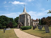
 | Church of St Mary & St Nicholas, Leatherhead The Church of St Mary & St Nicholas is an Anglican parish church in Leatherhead, Surrey. Dating originally to around the 11th century, it remains a place of worship to this day. It is a Grade II* listed building. |
 | The Rye (brook) The Rye is a stream rising east of Ashtead and flowing into the River Mole near Leatherhead, Surrey. It rises east of Ashtead and flows east of Leatherhead and flows into the River Mole. |
 | Church of St Mary, Fetcham St Mary’s Church, Fetcham, Surrey, is a Church of England parish church (community) but also refers to its building which dates to the 11th century, that of the Norman Conquest. It is set off the residential road of its address, The Ridgeway, behind a small park, in the suburban part of the largely 20th century railway settlement adjoining the M25 London Orbital Motorway. |
 | Bocketts Farm Bocketts Farm in Surrey is a visitor attraction farm set in the countryside on the slopes of the North Downs 1.6 miles (2.6 km) due south of Leatherhead. |
 | Norbury Park Norbury Park is a swathe of mixed wooded and agricultural land associated with its Georgian manor house near Leatherhead and Dorking, Surrey. It occupies mostly prominent land reaching into a bend in the Mole in the parish of Mickleham. |
 | Headley Court Defence Medical Rehabilitation Centre Headley Court was an 85-acre (34 ha) facility in Headley, near Epsom, Surrey. It was used as a rehabilitation centre for injured members of the British Armed Forces between 1985 and 2018. The site was sold by the MoD in 2018, upon purchase of Stanford Hall and conversion to the Defence and National Rehabilitation Center. |
 | St. Michael’s Churchyard, Mickleham St. Michael’s Churchyard is a church and graveyard located in Mickleham, Surrey, England. It belongs to the Church of England parish of St. Mickleham. |
 | Juniper Hall Juniper Hall is an 18th-century country house on the east slopes of Mickleham in the deep Mole Gap of the North Downs in Surrey. Opened as a field centre in 1947, it was one of the original four opened by the Field Studies Council. |
Visit Leatherhead plaques
 6
6
plaques
here Leatherhead has 6 physical plaques in tourist plaque schemes for you to explore via Walkfo Leatherhead plaques audio map when visiting. Plaques like National Heritage’s “Blue Plaques” provide visual geo-markers to highlight points-of-interest at the places where they happened – and Walkfo’s AI has researched additional, deeper content when you visit Leatherhead using the app. Experience the history of a location when Walkfo local tourist guide app triggers audio close to each Leatherhead plaque. Explore Plaques & History has a complete list of Hartlepool’s plaques & Hartlepool history plaque map.


 Trying to encourage visitors to Leatherhead?