Welcome to Visit Kirkintilloch Places
The Walkfo guide to things to do & explore in Kirkintilloch
 Visit Kirkintilloch places using Walkfo for free guided tours of the best Kirkintilloch places to visit. A unique way to experience Kirkintilloch’s places, Walkfo allows you to explore Kirkintilloch as you would a museum or art gallery with audio guides.
Visiting Kirkintilloch Walkfo Preview
Kirkintilloch is a town and former barony burgh in East Dunbartonshire, Scotland . It lies on the Forth and Clyde Canal and on the south side of Strathkelvin, about 8 miles (13 km) northeast of central Glasgow . It is the administrative home of East Dunbaronshire council area, its population in 2009 was estimated at 19,700 . When you visit Kirkintilloch, Walkfo brings Kirkintilloch places to life as you travel by foot, bike, bus or car with a mobile phone & headphones.
Kirkintilloch Places Overview: History, Culture & Facts about Kirkintilloch
Visit Kirkintilloch – Walkfo’s stats for the places to visit
With 29 audio plaques & Kirkintilloch places for you to explore in the Kirkintilloch area, Walkfo is the world’s largest heritage & history digital plaque provider. The AI continually learns & refines facts about the best Kirkintilloch places to visit from travel & tourism authorities (like Wikipedia), converting history into an interactive audio experience.
Kirkintilloch history
The first known settlement on the site of what is now Kirkintilloch was a Roman fort established in what is now the Peel Park area of the town. Dating from the mid-2nd century, the Antonine Wall, one of the northernmost frontiers in Roman Britannia was routed through Kirkintilloch; its course continues through the centre of the town to this day, although little trace can now be seen above ground. A digital reconstruction of the fort has been created. There are many archeological artifacts found in Kirkintilloch on display at the Hunterian Museum in Glasgow. There is no strong evidence of habitation on the site for the following thousand years until Clan Cumming established a castle (Motte and Bailey) and church there in the 12th century. A small settlement grew and was granted burgh status in 1211, becoming an important staging post for west–east journeys from Glasgow to eastern and north-eastern Scotland. From this time, a weekly market was held in the town, probably at the foot of Peel Brae (along with High Street and Cowgate, one of the three medieval thoroughfares in the town). The castle was of some importance during the wars of independence when an English garrison was stationed there, commanded by Sir Philip de Moubray, who was later to command Stirling Castle at the time of the Battle of Bannockburn. Soldiers from the castle were dispatched to arrest William Wallace at Robroyston in 1305 and escorted him to Dumbarton Castle. Later the same year, the garrison is recorded as having sent a petition to King Edward of England complaining of non-payment of wages. The castle was attacked by Scottish forces in 1306 under Bishop Wishart of Glasgow (using timber given to Glasgow diocese by the English for cathedral repairs), but the siege was unsuccessful. The castle is thought to have been destroyed on the orders of Robert Bruce later in the conflict, although the traces of a mot surrounded by a ditch can still be seen in the Peel Park. The original Cumming parish church, St Ninian’s, was constructed around 1140 some distance to the east of the town (where some of the stones remain in the form of an 18th-century watchtower at the entrance to the Auld Aisle Cemetery) as Kirkintilloch was originally in the parish of Lenzie which stretched from Cumbernauld in the East to Kirkintilloch in the West. The establishment was part of the endowment of Cambuskenneth Abbey, and was accompanied by a grant of one oxgang of land (approximately 15 acres), the measurement that lent its name to the area near the church. A chapel to the Virgin Mary was established in the town itself, sometime before 1379, and was endowed with land at Duntiblae by Sir David Fleming. The move of the parish church to the site of the chapel at Kirkintilloch Cross (now the Auld Kirk Museum) in 1644 resulted in a split of the Parish into Easter and Wester Lenzie (later Cumbernauld and Kirkintilloch Parishes) The name Lenzie was later reused for Kirkintilloch’s railway station on the main Glasgow to Edinburgh line, around which the later village of that name developed. Following the Scottish victory in the wars of independence and the subsequent decline of Clan Cumming, the baronies of Kirkintilloch, Lenzie, and Cumbernauld were granted by Robert Bruce to Sir Malcolm Fleming, Sheriff of Dumbarton and a supporter of the Bruce faction in the war. Hitherto part of Stirlingshire, the area subsequently became a detached part of the county of Dumbarton, in which it remains today. On 3 January 1746, the retreating Jacobite army of Charles Stuart made its way through Kirkintilloch, on its way back from Derby, and on the march to Falkirk and ultimately Culloden. One of the Highland army’s stragglers was shot dead at the town cross by a man hidden in a barn at the Kiln Close (where the library now stands). On hearing of the murder, Charles halted his army on the Kilsyth road and threatened to turn back and burn the town. The town magistrates persuaded him to continue marching, in return for an unspecified payment, and the town was spared. The town was one of the hotbeds of the Industrial Revolution in Scotland, beginning with the emergence of a booming textile industry in the area. There were 185 weavers in Kirkintilloch by 1790, and in 1867 James Slimon’s cotton mill at Kelvinside employed 200 women. With the construction of the Forth and Clyde Canal through the town in 1773, and the establishment of the Monkland and Kirkintilloch Railway in 1826, Kirkintilloch developed further as an important transportation hub, inland port and production centre for iron, coal, nickel and even small ships. This industrial heritage lives on in the town’s designation as the “Canal Capital of Scotland”, and in the redevelopment of the canal and surrounding former industrial sites in the early 21st century. By the 20th century, the principal employers in the town were the shipbuilders J & J Hay and Peter McGregor, and the Lion (1880–1984) and Star foundries, all of which produced goods for the domestic market and for export around the world. Kirkintilloch’s most famous exports were the distinctive red British postboxes and phoneboxes K2 to K6, produced in the town until 1984 and still to be found as far afield as Taiwan and Mississippi. Listed versions of these boxes still stand at the foot of Alexandra Street in the centre of Kirkintilloch. Kirkintilloch was a “dry town” for much of its recent history, with the sale of alcohol on public premises banned from 1923 until 1967. The prohibition on the sale of alcohol had long been demanded by the Liberal Party and the temperance movement, both of which had a strong influence in the town in the early part of the 20th century, largely due to the perceived negative effects of alcohol on the town’s inhabitants. The 1960s development plan to redevelop inner city areas of Glasgow saw Kirkintilloch used as an overspill settlement for relocated Glaswegians in combination with the new towns of Livingston and Cumbernauld, offering employment in housebuilding and an increase to the local population to its current levels. Large numbers of new houses for owner occupation have been built since that time.
Kirkintilloch culture & places

Kirkintilloch Town Hall was opened in 1906, paid for by public subscription. Work began on the redevelopment of the hall in early summer 2016, with major works completed in October 2017. The town is served by the William Patrick Library, which moved from a converted private villa near Peel Park to a new building in the 1990s.
Kirkintilloch toponymy

“Kirkintilloch” comes from the Gaelic Cair Cheann Tulaich, meaning “fort at the end of the hill” The long name is often shortened by locals to the colloquial Kirkie or Kirky. A possible reference to the site is made in the 9th century Welsh text Historia Brittonum.
Kirkintilloch geography / climate
The Forth and Clyde Canal passes through Kirkintilloch. The canal crossing the Luggie on an aqueduct flows into the River Kelvin which flows to the River Clyde in Glasgow.
Why visit Kirkintilloch with Walkfo Travel Guide App?
 You can visit Kirkintilloch places with Walkfo Kirkintilloch to hear history at Kirkintilloch’s places whilst walking around using the free digital tour app. Walkfo Kirkintilloch has 29 places to visit in our interactive Kirkintilloch map, with amazing history, culture & travel facts you can explore the same way you would at a museum or art gallery with information audio headset. With Walkfo, you can travel by foot, bike or bus throughout Kirkintilloch, being in the moment, without digital distraction or limits to a specific walking route. Our historic audio walks, National Trust interactive audio experiences, digital tour guides for English Heritage locations are available at Kirkintilloch places, with a AI tour guide to help you get the best from a visit to Kirkintilloch & the surrounding areas.
“Curated content for millions of locations across the UK, with 29 audio facts unique to Kirkintilloch places in an interactive Kirkintilloch map you can explore.”
Walkfo: Visit Kirkintilloch Places Map
29 tourist, history, culture & geography spots
Kirkintilloch historic spots | Kirkintilloch tourist destinations | Kirkintilloch plaques | Kirkintilloch geographic features |
| Walkfo Kirkintilloch tourism map key: places to see & visit like National Trust sites, Blue Plaques, English Heritage locations & top tourist destinations in Kirkintilloch | |||
Best Kirkintilloch places to visit
Kirkintilloch has places to explore by foot, bike or bus. Below are a selection of the varied Kirkintilloch’s destinations you can visit with additional content available at the Walkfo Kirkintilloch’s information audio spots:
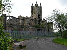 | Woodilee Hospital Woodilee Hospital was a psychiatric institution situated in Lenzie, East Dunbartonshire, Scotland . It was situated in the area of Lenzie in East Dunbaronshire . |
 | Kirkintilloch Town Hall Kirkintilloch Town Hall is a municipal building in East Dunbartonshire, Scotland . It is a category B listed building . The town hall is located in Union Street in Kirkintiloch, East Dunbaronshire . |
 | Broomhill Hospital Broomhill Hospital was a health facility in Kirkintilloch, East Dunbartonshire, Scotland . It was established in the 1930s and was set up in the mid-1940s . |
 | St Cyprian’s Church, Lenzie St Cyprian’s Church is an episcopal church in Lenzie, East Dunbartonshire, Scotland . It was built in 1873 by Alexander Ross of Inverness and cost around £2600 . |
 | Gadloch The Gadloch (also colloquially referred to as Lenzie Loch) is a fresh water loch in North Lanarkshire, Scotland . To the south of the loch is the small village of Auchinloch, the village’s name means “Field of the Loch” |
Visit Kirkintilloch plaques
 0
0
plaques
here Kirkintilloch has 0 physical plaques in tourist plaque schemes for you to explore via Walkfo Kirkintilloch plaques audio map when visiting. Plaques like National Heritage’s “Blue Plaques” provide visual geo-markers to highlight points-of-interest at the places where they happened – and Walkfo’s AI has researched additional, deeper content when you visit Kirkintilloch using the app. Experience the history of a location when Walkfo local tourist guide app triggers audio close to each Kirkintilloch plaque. Currently No Physical Plaques.


 Trying to encourage visitors to Kirkintilloch?