Welcome to Visit Kerris Places
The Walkfo guide to things to do & explore in Kerris
 Visit Kerris places using Walkfo for free guided tours of the best Kerris places to visit. A unique way to experience Kerris’s places, Walkfo allows you to explore Kerris as you would a museum or art gallery with audio guides.
Visiting Kerris Walkfo Preview
Kerris means “fort-place” in the Cornish language. It is three miles (5 km) south-west of Penzance in the civil parish of Paul. When you visit Kerris, Walkfo brings Kerris places to life as you travel by foot, bike, bus or car with a mobile phone & headphones.
Kerris Places Overview: History, Culture & Facts about Kerris
Visit Kerris – Walkfo’s stats for the places to visit
With 48 audio plaques & Kerris places for you to explore in the Kerris area, Walkfo is the world’s largest heritage & history digital plaque provider. The AI continually learns & refines facts about the best Kerris places to visit from travel & tourism authorities (like Wikipedia), converting history into an interactive audio experience.
Kerris history
Kerris was under three different ownerships until 1694 when Richard Pearce bought the three parts. The property was bought by the owner of an adjacent tenement for £4,320 in 1882. The former manor house is a grade II* listed building dating back to the 17th century.
Kerris culture & places
Kerris Brass Band was in attendance at Sheffield’s Methodist New Connexion, annual Sunday school treat in June 1883. Annual Sunday school treats were a treat for Sunday school children.
Kerris toponymy
In 1302 a document spells the name Veor Keris and other spellings have been Kerres (in 1310), Kyrrys (1337), Vean Kerrys (1440), Keres (1481), Kyrris (1668) and Veor means large or great and Vean means little.
Why visit Kerris with Walkfo Travel Guide App?
 You can visit Kerris places with Walkfo Kerris to hear history at Kerris’s places whilst walking around using the free digital tour app. Walkfo Kerris has 48 places to visit in our interactive Kerris map, with amazing history, culture & travel facts you can explore the same way you would at a museum or art gallery with information audio headset. With Walkfo, you can travel by foot, bike or bus throughout Kerris, being in the moment, without digital distraction or limits to a specific walking route. Our historic audio walks, National Trust interactive audio experiences, digital tour guides for English Heritage locations are available at Kerris places, with a AI tour guide to help you get the best from a visit to Kerris & the surrounding areas.
“Curated content for millions of locations across the UK, with 48 audio facts unique to Kerris places in an interactive Kerris map you can explore.”
Walkfo: Visit Kerris Places Map
48 tourist, history, culture & geography spots
Kerris historic spots | Kerris tourist destinations | Kerris plaques | Kerris geographic features |
| Walkfo Kerris tourism map key: places to see & visit like National Trust sites, Blue Plaques, English Heritage locations & top tourist destinations in Kerris | |||
Best Kerris places to visit
Kerris has places to explore by foot, bike or bus. Below are a selection of the varied Kerris’s destinations you can visit with additional content available at the Walkfo Kerris’s information audio spots:
 | St Pol de Léon’s Church, Paul St Pol de Léon’s Church, Paul also known as Paul Parish Church is a parish church in the Church of England Diocese of Truro located in Paul, Cornwall, UK. |
| Mousehole A.F.C. Mousehole Association Football Club is a football club based in Mousehole, Cornwall. They are currently members of the Western League Premier Division and play at Trungle Parc. |
 | Newlyn Art Gallery Newlyn Art Gallery is a contemporary art gallery located in Newlyn, Cornwall, UK. Opened in 1895, designed by James Hicks of Redruth and financed by John Passmore Edwards the gallery was conceived as a home and exhibition venue for the Newlyn School of Art. Recent shows have included retrospectives by Roger Hilton and Breon O’Casey. |
 | Chyenhal Moor Chyenhal Moor is a poorly drained shallow valley, 2 miles (3.2 km) to the south-west of Penzance, Cornwall. Due to several rare plants in a diverse range of habitats, it was notified as a Site of Special Scientific Interest in 1951. |
| Sancreed Beacon Sancreed Beacon is a Bronze Age archaeological site on the Penwith peninsula of Cornwall. On top of the hill are several stone cists and Bronze Age remains comprising burial mounds and the remains of the Bronze Age hut. |
 | Penlee House Penlee House is a museum and art gallery located in Penzance, Cornwall. It is home to paintings by members of the Newlyn School, including many by Stanhope Forbes, Norman Garstin, Walter Langley and Lamorna Birch. |
 | Penzance A.F.C. Penzance Association Football Club was established in 1888. They were founding members of the South Western League in 1951. They currently play in the South West Peninsula League Premier Division West. |
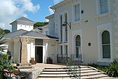
 | Castle Horneck Castle Horneck is a refurbished Georgian mansion to the west of the Cornish town of Penzance. It is currently owned by the Youth Hostels Association (YHA) and has been used as a youth hostel since 1950. |
 | Lesingey Round Lesingey Round is a ringfort, a smaller type of hillfort, about 1 mile (1.6 km) west of Penzance, in Cornwall. A ’round’ is a small circular embanked enclosure, with one entrance. |
 | Trereife House Trereife House (pronounced Treeve) is a grade II listed manor house located west of Penzance in Cornwall. The house was built in the 18th century and has two storeys and a hipped roof with dormer windows. |
Visit Kerris plaques
 6
6
plaques
here Kerris has 6 physical plaques in tourist plaque schemes for you to explore via Walkfo Kerris plaques audio map when visiting. Plaques like National Heritage’s “Blue Plaques” provide visual geo-markers to highlight points-of-interest at the places where they happened – and Walkfo’s AI has researched additional, deeper content when you visit Kerris using the app. Experience the history of a location when Walkfo local tourist guide app triggers audio close to each Kerris plaque. Explore Plaques & History has a complete list of Hartlepool’s plaques & Hartlepool history plaque map.


 Trying to encourage visitors to Kerris?