Welcome to Visit Kearsley Places
The Walkfo guide to things to do & explore in Kearsley
 Visit Kearsley places using Walkfo for free guided tours of the best Kearsley places to visit. A unique way to experience Kearsley’s places, Walkfo allows you to explore Kearsley as you would a museum or art gallery with audio guides.
Visiting Kearsley Walkfo Preview
Kearsley was a township in the ancient ecclesiastical parish of Deane, in the Hundred of Salford. It lies 8 miles (13 km) northwest of Manchester, 5 miles (8 km) southwest of Bury and 3+3/4 miles (6 km) south of Bolton. The population at the 2011 census was 14,212. When you visit Kearsley, Walkfo brings Kearsley places to life as you travel by foot, bike, bus or car with a mobile phone & headphones.
Kearsley Places Overview: History, Culture & Facts about Kearsley
Visit Kearsley – Walkfo’s stats for the places to visit
With 78 audio plaques & Kearsley places for you to explore in the Kearsley area, Walkfo is the world’s largest heritage & history digital plaque provider. The AI continually learns & refines facts about the best Kearsley places to visit from travel & tourism authorities (like Wikipedia), converting history into an interactive audio experience.
Kearsley history

Kearsley lay within historic county boundaries of Lancashire. Industrialised by 1752 when James Brindley solved drainage problems at Wet Earth Colliery. Papermill, cotton mills, chemical works, an iron foundry, a quarry and 15 coal mines operated within its boundaries. By 1900 the coal mining industry had all but disappeared.
Why visit Kearsley with Walkfo Travel Guide App?
 You can visit Kearsley places with Walkfo Kearsley to hear history at Kearsley’s places whilst walking around using the free digital tour app. Walkfo Kearsley has 78 places to visit in our interactive Kearsley map, with amazing history, culture & travel facts you can explore the same way you would at a museum or art gallery with information audio headset. With Walkfo, you can travel by foot, bike or bus throughout Kearsley, being in the moment, without digital distraction or limits to a specific walking route. Our historic audio walks, National Trust interactive audio experiences, digital tour guides for English Heritage locations are available at Kearsley places, with a AI tour guide to help you get the best from a visit to Kearsley & the surrounding areas.
“Curated content for millions of locations across the UK, with 78 audio facts unique to Kearsley places in an interactive Kearsley map you can explore.”
Walkfo: Visit Kearsley Places Map
78 tourist, history, culture & geography spots
Kearsley historic spots | Kearsley tourist destinations | Kearsley plaques | Kearsley geographic features |
| Walkfo Kearsley tourism map key: places to see & visit like National Trust sites, Blue Plaques, English Heritage locations & top tourist destinations in Kearsley | |||
Best Kearsley places to visit
Kearsley has places to explore by foot, bike or bus. Below are a selection of the varied Kearsley’s destinations you can visit with additional content available at the Walkfo Kearsley’s information audio spots:
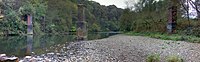
 | Nob End Nob End is the site of a former waste tip near Little Lever and Kearsley, in Greater Manchester. It is now a Site of Special Scientific Interest and Local Nature Reserve. |
 | Moses Gate Country Park Moses Gate Country Park, part of which is also known as Crompton Lodges, is a 750 acre (300 hectare) site situated at Moses Gate in the Croal and Irwell Valleys. It is a Local Nature Reserve. |
 | Kearsley Mill Kearsley Mill is a 240,000 sq ft (22,000 m), late period cotton mill located in the small village of Prestolee, Greater Manchester. A near complete example of Edwardian mill architecture, the building functions as headquarters for a number of businesses. |
 | Ladyshore Colliery Ladyshore Colliery, originally named Back o’ th Barn, was situated on the Irwell Valley fault on the Manchester Coalfield in Little Lever, Lancashire. Founded by Thomas Fletcher Senior, the colliery opened in the 1830s and mined several types of coal. |
 | Lever Bank Bleach Works Lever Bank Bleach Works was a Bleach Works at Ladyshore, near Little Lever, Bolton. The works was owned by Thomas Ridgway & Sons. Former British Prime Minister Tony Blair would appear to be a direct descendant of this family. |
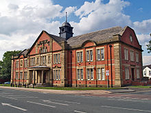 | Municipal Borough of Farnworth Municipal Borough of Farnworth was an unparished area of the Metropolitan Borough of Bolton in Greater Manchester. A local board of health had been established for Farnworth in 1863, which was reconstituted as an urban district in 1899 and granted a charter of incorporation in 1939. |
 | St Mary the Virgin’s Church, Ellenbrook St Mary the Virgin’s Church or Ellenbrook Chapel is an active Anglican church in Ellenbrook, Worsley, Greater Manchester. The church was granted Grade II listed status in 1966. It is in the Eccles deanery, archdeaconry of Salford and diocese of Manchester. |
 | Boothstown and Ellenbrook (ward) The ward was created in 2004 following recommendations made by the Boundary Committee for England. It is represented in Westminster by Barbara Keeley MP for Worsley and Eccles South. The 2011 Census recorded a population of 9,532. |
 | New Manchester New Manchester or The City was an isolated mining community on the Manchester Coalfield. It lies west of a boundary stone at Ellenbrook which marks the ancient boundary of the Hundreds of Salford and West Derby. The Roman road from Manchester to Wigan and the Tyldesley Loopline passed south of the village. |
 | Walkden South Walkden South is an area and electoral ward of Salford, England. It is represented in Westminster by Barbara Keeley MP for Worsley and Eccles South. |
Visit Kearsley plaques
 24
24
plaques
here Kearsley has 24 physical plaques in tourist plaque schemes for you to explore via Walkfo Kearsley plaques audio map when visiting. Plaques like National Heritage’s “Blue Plaques” provide visual geo-markers to highlight points-of-interest at the places where they happened – and Walkfo’s AI has researched additional, deeper content when you visit Kearsley using the app. Experience the history of a location when Walkfo local tourist guide app triggers audio close to each Kearsley plaque. Explore Plaques & History has a complete list of Hartlepool’s plaques & Hartlepool history plaque map.


 Trying to encourage visitors to Kearsley?