Welcome to Visit Irlam Places
The Walkfo guide to things to do & explore in Irlam
 Visit Irlam places using Walkfo for free guided tours of the best Irlam places to visit. A unique way to experience Irlam’s places, Walkfo allows you to explore Irlam as you would a museum or art gallery with audio guides.
Visiting Irlam Walkfo Preview
Irlam lies on the south side of the M62 motorway and the north bank of the Manchester Ship Canal. It lies 6.7 miles (10.8 km) southwest of Salford, 7.6 miles southwest of Manchester and 8.3 miles (13.4 km) northeast of Warrington. The main road through Irlam, linking it to Cadishead and Eccles, is the A57. When you visit Irlam, Walkfo brings Irlam places to life as you travel by foot, bike, bus or car with a mobile phone & headphones.
Irlam Places Overview: History, Culture & Facts about Irlam
Visit Irlam – Walkfo’s stats for the places to visit
With 24 audio plaques & Irlam places for you to explore in the Irlam area, Walkfo is the world’s largest heritage & history digital plaque provider. The AI continually learns & refines facts about the best Irlam places to visit from travel & tourism authorities (like Wikipedia), converting history into an interactive audio experience.
Irlam history
Irlam is on the north bank of the River Irwell, from which it almost certainly takes its name, being known in the 13th century as Irwellham. Until the arrival of the Cheshire Lines Committee railway and the opening of Irlam railway station in 1873, Irlam remained a largely undeveloped village. Irlam Urban District was created in 1894, the same year that the Manchester Ship Canal opened.
Why visit Irlam with Walkfo Travel Guide App?
 You can visit Irlam places with Walkfo Irlam to hear history at Irlam’s places whilst walking around using the free digital tour app. Walkfo Irlam has 24 places to visit in our interactive Irlam map, with amazing history, culture & travel facts you can explore the same way you would at a museum or art gallery with information audio headset. With Walkfo, you can travel by foot, bike or bus throughout Irlam, being in the moment, without digital distraction or limits to a specific walking route. Our historic audio walks, National Trust interactive audio experiences, digital tour guides for English Heritage locations are available at Irlam places, with a AI tour guide to help you get the best from a visit to Irlam & the surrounding areas.
“Curated content for millions of locations across the UK, with 24 audio facts unique to Irlam places in an interactive Irlam map you can explore.”
Walkfo: Visit Irlam Places Map
24 tourist, history, culture & geography spots
Irlam historic spots | Irlam tourist destinations | Irlam plaques | Irlam geographic features |
| Walkfo Irlam tourism map key: places to see & visit like National Trust sites, Blue Plaques, English Heritage locations & top tourist destinations in Irlam | |||
Best Irlam places to visit
Irlam has places to explore by foot, bike or bus. Below are a selection of the varied Irlam’s destinations you can visit with additional content available at the Walkfo Irlam’s information audio spots:

St George’s Church, Carrington
St George’s Church is in the village of Carrington, Trafford, Greater Manchester. It is recorded in the National Heritage List for England as a designated Grade II* listed building. It stands in a relatively isolated position south of the Manchester Ship Canal.

Glazebrook East Junction–Skelton Junction line
Glazebrook East Junction–Skelton Junction line was a railway line. It was a line from Glazbrook, Greater Manchester, to Skelton. It ran between Glazabrook and Skelon Junction in Greater Manchester.

Flixton House
Flixton House was built in 1806 by the Wright family, who had become wealthy land owners. Ralph Wright in 1826 closed several footpaths across his estate, which the public had until then been allowed access to. In response to the closure, the people of Flixon initiated and funded a court case against Wright, one of the first footpath battles in England.

St Michael’s Church, Flixton
St Michael’s Church, Flixton, Greater Manchester, is an Anglican parish church dedicated to Michael the Archangel. It lies in the Diocese of Manchester, in the Anglican Diocese previously in Lichfield.
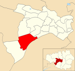
Irlam (ward)
Irlam is an electoral ward of Salford, England. It is represented in Westminster by Barbara Keeley MP for Worsley and Eccles South.
Visit Irlam plaques
 2
2
plaques
here Irlam has 2 physical plaques in tourist plaque schemes for you to explore via Walkfo Irlam plaques audio map when visiting. Plaques like National Heritage’s “Blue Plaques” provide visual geo-markers to highlight points-of-interest at the places where they happened – and Walkfo’s AI has researched additional, deeper content when you visit Irlam using the app. Experience the history of a location when Walkfo local tourist guide app triggers audio close to each Irlam plaque. Explore Plaques & History has a complete list of Hartlepool’s plaques & Hartlepool history plaque map.


 Trying to encourage visitors to Irlam?