Welcome to Visit Horsham Places
The Walkfo guide to things to do & explore in Horsham
![]() Visit Horsham places using Walkfo for free guided tours of the best Horsham places to visit. A unique way to experience Horsham’s places, Walkfo allows you to explore Horsham as you would a museum or art gallery with audio guides.
Visit Horsham places using Walkfo for free guided tours of the best Horsham places to visit. A unique way to experience Horsham’s places, Walkfo allows you to explore Horsham as you would a museum or art gallery with audio guides.
Visiting Horsham Walkfo Preview
Horsham is 31 miles (50 km) south south-west of London and 18.5 miles (30 km) north-east of Brighton. Nearby towns include Crawley to the north and Haywards Heath to the south-east. When you visit Horsham, Walkfo brings Horsham places to life as you travel by foot, bike, bus or car with a mobile phone & headphones.
Horsham Places Overview: History, Culture & Facts about Horsham
Visit Horsham – Walkfo’s stats for the places to visit
With 38 audio plaques & Horsham places for you to explore in the Horsham area, Walkfo is the world’s largest heritage & history digital plaque provider. The AI continually learns & refines facts about the best Horsham places to visit from travel & tourism authorities (like Wikipedia), converting history into an interactive audio experience.
Horsham landmarks
In the commercial centre of Horsham is an open pedestrianised square known as the Carfax. This area contains the Town’s Memorial to the dead of the two world wars, a substantial, well-used bandstand and is the venue for Saturday and Thursday markets. The name Carfax is likely of Norman origin – a corruption of ‘Quatre Voies’ (four ways) or ‘Carrefour’
Horsham geography / climate
Weather
Horsham holds the UK record for the heaviest hailstone ever to fall. A hailstone weighing 140g (4.9 oz) landed in the town on 5 September 1958. Impact speeds have been calculated to be 100 m/s (224 mph)
Topography
Horsham is in the centre of the Weald in the Low Weald, at the western edge of the High Weald. The River Arun rises from ghylls in the St Leonard’s Forest area, to the east of the town. The Arun is joined by a number of streams flowing down from the north.
Town centre
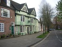
To the south of the Carfax is the Causeway, a street lined with ancient London Plane trees. The Horsham Museum is at the north end opposite to the recently developed former headquarters of the R.S.P.C.A.A.. At the south end is the Church of England parish church of St. Mary.
Suburbs
Horsham has developed beyond the original boundaries to incorporate some of the smaller hamlets which now form part of the outer districts. The Needles estate was laid out from 1955, with a mixture of privately owned and council-built houses and bungalows. Roffey is north east of the centre of the town and as a hamlet dates back to at least the 13th century.
Why visit Horsham with Walkfo Travel Guide App?
![]() You can visit Horsham places with Walkfo Horsham to hear history at Horsham’s places whilst walking around using the free digital tour app. Walkfo Horsham has 38 places to visit in our interactive Horsham map, with amazing history, culture & travel facts you can explore the same way you would at a museum or art gallery with information audio headset. With Walkfo, you can travel by foot, bike or bus throughout Horsham, being in the moment, without digital distraction or limits to a specific walking route. Our historic audio walks, National Trust interactive audio experiences, digital tour guides for English Heritage locations are available at Horsham places, with a AI tour guide to help you get the best from a visit to Horsham & the surrounding areas.
You can visit Horsham places with Walkfo Horsham to hear history at Horsham’s places whilst walking around using the free digital tour app. Walkfo Horsham has 38 places to visit in our interactive Horsham map, with amazing history, culture & travel facts you can explore the same way you would at a museum or art gallery with information audio headset. With Walkfo, you can travel by foot, bike or bus throughout Horsham, being in the moment, without digital distraction or limits to a specific walking route. Our historic audio walks, National Trust interactive audio experiences, digital tour guides for English Heritage locations are available at Horsham places, with a AI tour guide to help you get the best from a visit to Horsham & the surrounding areas.
“Curated content for millions of locations across the UK, with 38 audio facts unique to Horsham places in an interactive Horsham map you can explore.”
Walkfo: Visit Horsham Places Map
38 tourist, history, culture & geography spots
Horsham historic spots | Horsham tourist destinations | Horsham plaques | Horsham geographic features |
| Walkfo Horsham tourism map key: places to see & visit like National Trust sites, Blue Plaques, English Heritage locations & top tourist destinations in Horsham | |||
Best Horsham places to visit
Horsham has places to explore by foot, bike or bus. Below are a selection of the varied Horsham’s destinations you can visit with additional content available at the Walkfo Horsham’s information audio spots:
 | Horsham Hospital Horsham Hospital is a health facility at Hurst Road in West Sussex, England. It is managed by Sussex Community NHS Foundation Trust. |
 | Horsham Town Hall Horsham Town Hall is a municipal building in the Market Square in West Sussex. It is a Grade II listed building. It was built in the 1930s and is located in the market square. |
 | Horsham Museum Horsham Museum was founded in August 1893 by volunteers of the Free Christian (now Unitarian) Church. It is a fully accredited museum with an active volunteer base. |
 | Bohunt Horsham Bohunt Horsham is a coeducational all-through school in West Sussex. The school opened to 120 students in Year 7 in 2019. A new, purpose-built school is currently in development North of the town. Eventually the school will take 1620 students from ages 4–16. |
 | Horsham YMCA F.C. Horsham YMCA are a football club based in West Sussex, England. They are currently members of the Southern Combination Premier Division and play at Gorings Mead. |
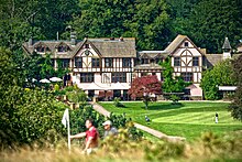
 | Mannings Heath Golf & Wine Estate Mannings Heath Golf & Wine Estate includes two golf courses and a vineyard. The 500 acre parkland site was acquired by Penny Streeter OBE in 2016. It is a division of The Benguela Collection, a wine producer and hospitality group. |
 | Roffey F.C. Roffey F.C. are currently members of the Southern Combination Division One. They play at the Bartholomew Way Ground in West Sussex. |
 | St Leonard’s Forest St Leonard’s Forest is at the western end of the Wealden Forest Ridge which runs from Horsham to Tonbridge. It is one of the “Fower stately Wood Nymphs” of the Forest Ridge (the other three being Worth, Ashdown and Waterdown forests) which were part of the ancient Andreaswald or Andreadswald. St Leonardslee Gardens were open to the public until 2010 and re-opened in April 2019. |
Visit Horsham plaques
![]() 4
4
plaques
here Horsham has 4 physical plaques in tourist plaque schemes for you to explore via Walkfo Horsham plaques audio map when visiting. Plaques like National Heritage’s “Blue Plaques” provide visual geo-markers to highlight points-of-interest at the places where they happened – and Walkfo’s AI has researched additional, deeper content when you visit Horsham using the app. Experience the history of a location when Walkfo local tourist guide app triggers audio close to each Horsham plaque. Explore Plaques & History has a complete list of Hartlepool’s plaques & Hartlepool history plaque map.