Welcome to Visit Hollingbury Places
The Walkfo guide to things to do & explore in Hollingbury
 Visit Hollingbury places using Walkfo for free guided tours of the best Hollingbury places to visit. A unique way to experience Hollingbury’s places, Walkfo allows you to explore Hollingbury as you would a museum or art gallery with audio guides.
Visiting Hollingbury Walkfo Preview
Hollingbury is an area of Brighton and Hove, East Sussex. The area sits high on a hillside across the north of the city, east of Patcham which lies in a valley to the west, Coldean and the A27 bypass forming the northern limit. It is where Triangulation Point TP3970 used for the 1936 Ordnance Survey mapping of Great Britain is located. When you visit Hollingbury, Walkfo brings Hollingbury places to life as you travel by foot, bike, bus or car with a mobile phone & headphones.
Hollingbury Places Overview: History, Culture & Facts about Hollingbury
Visit Hollingbury – Walkfo’s stats for the places to visit
With 110 audio plaques & Hollingbury places for you to explore in the Hollingbury area, Walkfo is the world’s largest heritage & history digital plaque provider. The AI continually learns & refines facts about the best Hollingbury places to visit from travel & tourism authorities (like Wikipedia), converting history into an interactive audio experience.
Hollingbury history

Hollingbury is the town’s largest post-war (World War II) council estate. The development is a mixture of bungalows, flats and houses with most of the earlier properties having large gardens. The estate is built on land originally acquired by the council in November 1909.
Why visit Hollingbury with Walkfo Travel Guide App?
 You can visit Hollingbury places with Walkfo Hollingbury to hear history at Hollingbury’s places whilst walking around using the free digital tour app. Walkfo Hollingbury has 110 places to visit in our interactive Hollingbury map, with amazing history, culture & travel facts you can explore the same way you would at a museum or art gallery with information audio headset. With Walkfo, you can travel by foot, bike or bus throughout Hollingbury, being in the moment, without digital distraction or limits to a specific walking route. Our historic audio walks, National Trust interactive audio experiences, digital tour guides for English Heritage locations are available at Hollingbury places, with a AI tour guide to help you get the best from a visit to Hollingbury & the surrounding areas.
“Curated content for millions of locations across the UK, with 110 audio facts unique to Hollingbury places in an interactive Hollingbury map you can explore.”
Walkfo: Visit Hollingbury Places Map
110 tourist, history, culture & geography spots
Hollingbury historic spots | Hollingbury tourist destinations | Hollingbury plaques | Hollingbury geographic features |
| Walkfo Hollingbury tourism map key: places to see & visit like National Trust sites, Blue Plaques, English Heritage locations & top tourist destinations in Hollingbury | |||
Best Hollingbury places to visit
Hollingbury has places to explore by foot, bike or bus. Below are a selection of the varied Hollingbury’s destinations you can visit with additional content available at the Walkfo Hollingbury’s information audio spots:
 | St Luke’s Church, Queen’s Park, Brighton St Luke’s Church is an Anglican church in the Queen’s Park area of Brighton. It was designed in the 1880s by Sir Arthur Blomfield in the Early English style. It has been given listed building status because of its architectural importance. |
 | Greek Orthodox Church of the Holy Trinity, Brighton The Church of the Holy Trinity is a Greek Orthodox church in Brighton. Built in 1838 in one of Brighton’s most notorious slum districts, Carlton Hill. It was an Anglican church for most of its life until it was declared redundant in 1980. It has been listed at Grade II since 1971. |
 | Church of the Annunciation, Brighton The Church of the Annunciation was built in the 1860s on behalf of Rev. Arthur Wagner. It served a new area of poor housing in what is now the Hanover district. The church is a Grade II listed building. |
 | St Wilfrid’s Church, Brighton St Wilfrid’s Church is a former Anglican church in the Elm Grove area of Brighton, part of the English city of Brighton and Hove. It was declared redundant after less than 50 years as a place of worship, and was converted into sheltered housing with minimal alteration to the exterior. |
 | The Blind Tiger Club, Brighton The Blind Tiger Club was a mixed music, arts and community venue in Brighton, England, which opened in 2010. Time Out described the venue as “semi-legendary”, in its round-up of Brighton’s live music scene that year. Gigwise included the club in their list of the UK’s Greatest Lost Venues. |
 | St Joseph’s Church, Brighton St Joseph’s Church is a Roman Catholic church in the Elm Grove area of Brighton, part of the English city of Brighton and Hove. It is one of eleven Roman Catholic churches in the city. The church was built in several stages, and outstanding debts meant that its official dedication took place in 1979. |
 | Percy and Wagner Almshouses The Percy and Wagner Almshouses are a group of 12 almshouses in the inner-city Hanover area of the English coastal city of Brighton and Hove. The first six date from 1795 and are among the few pre-19th-century buildings left in the city. The additional houses of 1859 were provided for unmarried women. The houses were saved from demolition in the 1970s and were rebuilt instead and are still occupied. |
 | Whitehawk Camp Whitehawk Camp is the remains of a causewayed enclosure on Whitehawk Hill near Brighton, East Sussex. Causewayed enclosures are a form of early Neolithic earthwork that were built in England from shortly before 3700 BC until about 3300 BC. Site consists of four roughly concentric circular circular circular ditches, with banks of earth along the interior of the ditches evident in some places. |
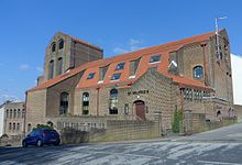
 | St Martin’s Church, Brighton St Martin’s Church is the largest Anglican church in Brighton, England. It dates back to the mid-Victorian era and is noted for its ornate interior. It is located northeast of the city centre and north of the seafront. |
 | Church Street drill hall, Brighton The Church Street drill hall is a former military installation in Brighton. It is a Grade II listed building which is used as a drill hall. |
Visit Hollingbury plaques
 43
43
plaques
here Hollingbury has 43 physical plaques in tourist plaque schemes for you to explore via Walkfo Hollingbury plaques audio map when visiting. Plaques like National Heritage’s “Blue Plaques” provide visual geo-markers to highlight points-of-interest at the places where they happened – and Walkfo’s AI has researched additional, deeper content when you visit Hollingbury using the app. Experience the history of a location when Walkfo local tourist guide app triggers audio close to each Hollingbury plaque. Explore Plaques & History has a complete list of Hartlepool’s plaques & Hartlepool history plaque map.


 Trying to encourage visitors to Hollingbury?