Welcome to Visit Hitchin Places
The Walkfo guide to things to do & explore in Hitchin
 Visit Hitchin places using Walkfo for free guided tours of the best Hitchin places to visit. A unique way to experience Hitchin’s places, Walkfo allows you to explore Hitchin as you would a museum or art gallery with audio guides.
Visiting Hitchin Walkfo Preview
Hitchin is a market town in the North Hertfordshire district. It has an estimated population of 33,350. Hitchin was the first market town to be named Hitchin. When you visit Hitchin, Walkfo brings Hitchin places to life as you travel by foot, bike, bus or car with a mobile phone & headphones.
Hitchin Places Overview: History, Culture & Facts about Hitchin
Visit Hitchin – Walkfo’s stats for the places to visit
With 43 audio plaques & Hitchin places for you to explore in the Hitchin area, Walkfo is the world’s largest heritage & history digital plaque provider. The AI continually learns & refines facts about the best Hitchin places to visit from travel & tourism authorities (like Wikipedia), converting history into an interactive audio experience.
Hitchin history
Hitchin is first noted as the central place of the Hicce people, a tribe holding 300 hides of land as mentioned in a 7th-century document, the Tribal Hidage. Hicce, or Hicca may mean the people of the horse. The tribal name is Old English and derives from the Middle Anglian people. It has been suggested that Hitchin was the location of ‘Clofeshoh’, the place chosen in 673 by Theodore of Tarsus the Archbishop of Canterbury during the Synod of Hertford, the first meeting of representatives of the fledgling Christian churches of Anglo-Saxon England, to hold annual synods of the churches as Theodore attempted to consolidate and centralise Christianity in England. By 1086 Hitchin is described as a Royal Manor in Domesday Book: the feudal services of Avera and Inward, usually found in the eastern counties, especially Cambridgeshire and Hertfordshire, were due from the sokemen, but the manor of Hitchin was unique in levying Inward. Evidence has been found to suggest that the town was once provided with an earthen bank and ditch fortification, probably in the early tenth century but this did not last. The modern spelling of the town first appears in 1618 in the “Hertfordshire Feet of Fines”. The name of the town also is associated with the small river that runs through it, most picturesquely in front of the east end of St. Mary’s Church, the town’s parish church. The river is noted on maps as the River Hiz. Contrary to how most people now pronounce the name, that is to say as spelt, the ‘z’ is an abbreviated character for a ‘tch’ sound in the Domesday Book (as in the name of the town). It would have been pronounced ‘River Hitch’. The Hicca Way is an eight-mile (thirteen-kilometre) walking route along the River Hiz Valley, believed to have been used for trade between the Danes and English in the Anglo-Saxon age. It is also likely that Hitch Wood, which lies some six miles (ten kilometres) south of the town also derives its name from the Hicce tribe, who gave their name to Hitchin. St. Mary’s Church is remarkably large for a town of its size and was once a Minster. The size of the church is evidence of how Hitchin prospered from the wool trade. It is the largest parish church in Hertfordshire. Most of the church dates from the 15th century, with its tower dating from around 1190. During the laying of a new floor in the church in 1911, foundations of a more ancient church building were found. In form, they appear to be a basilican church of a 7th-century type, with a later enlarged chancel and transepts, perhaps added in the 10th century. This makes the church older than the story (not recorded before the 15th century) that the church was founded by Offa, king of Mercia 757-796. In 1697, Hitchin (and the nearby village of Offley) were subject to what is thought to have been the most severe hailstorm in recorded British history. Hailstones over 4 inches in diameter were reported The town flourished on the wool trade, and located near the Icknield Way and by the 17th century Hitchin was a staging post for coaches coming from London. By the middle of the 19th century the railway had arrived, and with it a new way of life for Hitchin. The corn exchange was built in the market place and within a short time Hitchin established itself as a major centre for grain trading. The latter half of the 20th century has also brought great changes in communication to Hitchin. Motorways have shortened the journey time and brought Luton, a few miles away on the M1, and the A1 (M) even closer. By the close of the 20th century, Hitchin had developed a strong commuter interest being midway between London and Cambridge. Hitchin also developed a fairly strong Sikh community based around the Walsworth area. During the medieval period, both a priory (Newbigging, now known as The Biggin) and a friary (now known as Hitchin Priory) were established, both of which closed during Henry VIII’s Dissolution of the Monasteries. They were never reformed, although The Biggin was for many years used as almshouses. The British Schools Museum in Hitchin is home to the world’s only surviving complete Lancasterian Schoolroom, which was built in 1837 to teach boys by the Lancasterian method (peer tutoring). This unique community project demonstrates the foundation of education for all. Girton College – a pioneer in women’s education – was established on 16 October 1869 under the name of College for Women at Benslow House in Hitchin, which was considered to be a convenient distance from Cambridge and London. It was thought to be less ‘risky’ and less controversial to locate the college away from Cambridge in the beginning. The college moved to Cambridge a few years later and adopted its present name, Girton College.
Why visit Hitchin with Walkfo Travel Guide App?
 You can visit Hitchin places with Walkfo Hitchin to hear history at Hitchin’s places whilst walking around using the free digital tour app. Walkfo Hitchin has 43 places to visit in our interactive Hitchin map, with amazing history, culture & travel facts you can explore the same way you would at a museum or art gallery with information audio headset. With Walkfo, you can travel by foot, bike or bus throughout Hitchin, being in the moment, without digital distraction or limits to a specific walking route. Our historic audio walks, National Trust interactive audio experiences, digital tour guides for English Heritage locations are available at Hitchin places, with a AI tour guide to help you get the best from a visit to Hitchin & the surrounding areas.
“Curated content for millions of locations across the UK, with 43 audio facts unique to Hitchin places in an interactive Hitchin map you can explore.”
Walkfo: Visit Hitchin Places Map
43 tourist, history, culture & geography spots
Hitchin historic spots | Hitchin tourist destinations | Hitchin plaques | Hitchin geographic features |
| Walkfo Hitchin tourism map key: places to see & visit like National Trust sites, Blue Plaques, English Heritage locations & top tourist destinations in Hitchin | |||
Best Hitchin places to visit
Hitchin has places to explore by foot, bike or bus. Below are a selection of the varied Hitchin’s destinations you can visit with additional content available at the Walkfo Hitchin’s information audio spots:

Church of St Katharine, Ickleford
The Church of St Katharine of Alexandria is the Church of England parish church for Ickleford in Hertfordshire. It is a Grade I listed building and comes under the Diocese of St Albans.

River Purwell
The River Purwell is a chalk stream in Hertfordshire. Its source is springs which rise out of the chalk bedrock at St Ippolyts, forming Ippollitts Brook. The entire course of the stream is near Hitchin.

Hitchin Priory
Hitchin Priory in Hitchin in Hertfordshire is today a hotel built in about 1700 on the site of a Carmelite friary founded in 1317. Parts of the original priory are incorporated in the existing building, which has been a Grade I listed building since 1951.

Hitchin Museum and Art Gallery
The Hitchin Museum and Art Gallery was a local history museum in Hitchin, Hertfordshire. It told the story of the town’s social history and of the rural industries that contributed to its prosperity.

Hitchin Cemetery
Hitchin Cemetery, also known as St John’s Road Cemetery, is the main burial ground for the town of Hitchin. It has been owned and managed by North Hertfordshire District Council since 1974. The cemetery is located on Hitchin Hill, with Standhill Road running along the north-western boundary.
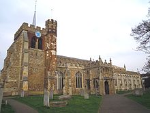
St Mary’s Church, Hitchin
St Mary’s Church is a Church of England parish church in Hitchin, Hertfordshire. It dates from the 14th and 15th centuries, with its tower dating from around 1190. The church has been Grade I listed since 1951. During the laying of a new floor in 1911, foundations of a more ancient Saxon church building were found.

Butts Close
Butts Close is an 11-acre (45,000 m) park in Hitchin, Hertfordshire. The name refers to the archery butts that used to be on it during the Late medieval and Tudor times. During those years it was much larger but in the last centuries it was built on it.

Church of St Mary the Virgin, Great Wymondley
St Mary’s Church is an active Anglican church in Great Wymondley, Hertfordshire. It is a Grade I listed building.
Visit Hitchin plaques
 2
2
plaques
here Hitchin has 2 physical plaques in tourist plaque schemes for you to explore via Walkfo Hitchin plaques audio map when visiting. Plaques like National Heritage’s “Blue Plaques” provide visual geo-markers to highlight points-of-interest at the places where they happened – and Walkfo’s AI has researched additional, deeper content when you visit Hitchin using the app. Experience the history of a location when Walkfo local tourist guide app triggers audio close to each Hitchin plaque. Explore Plaques & History has a complete list of Hartlepool’s plaques & Hartlepool history plaque map.


 Trying to encourage visitors to Hitchin?