Welcome to Visit Gwersyllt Places The Walkfo guide to things to do & explore in Gwersyllt
Visit Gwersyllt places using Walkfo for free guided tours of the best Gwersyllt places to visit. A unique way to experience Gwersyllt’s places, Walkfo allows you to explore Gwersyllt as you would a museum or art gallery with audio guides.
Visiting Gwersyllt Walkfo Preview Gwersyllt is an urban village and local government community in Wrexham County Borough, Wales. The community, also including the villages of Summerhill, Sydallt, Rhosrobin and Bradley, had a total population of 10,056 at the 2001 census, rising to 10,677 at the 2011 Census. The name is usually stated to be derived from the Welsh word gwersyll, meaning “campsite” When you visit Gwersyllt, Walkfo brings Gwersyllt places to life as you travel by foot, bike, bus or car with a mobile phone & headphones.
Gwersyllt Places Overview: History, Culture & Facts about Gwersyllt
Visit Gwersyllt – Walkfo’s stats for the places to visit
With 63 audio plaques & Gwersyllt places for you to explore in the Gwersyllt area, Walkfo is the world’s largest heritage & history digital plaque provider. The AI continually learns & refines facts about the best Gwersyllt places to visit from travel & tourism authorities (like Wikipedia), converting history into an interactive audio experience.
Gwersyllt history
Gwersyllt was originally a township of the parish of Gresford, and by 1833 had 834 inhabitants. The area was home to several collieries and a canal was planned to run through the community. In the mid-20th century, large council estates were built amongst the existing village.
Why visit Gwersyllt with Walkfo Travel Guide App?
You can visit Gwersyllt places with Walkfo Gwersyllt to hear history at Gwersyllt’s places whilst walking around using the free digital tour app. Walkfo Gwersyllt has 63 places to visit in our interactive Gwersyllt map, with amazing history, culture & travel facts you can explore the same way you would at a museum or art gallery with information audio headset. With Walkfo, you can travel by foot, bike or bus throughout Gwersyllt, being in the moment, without digital distraction or limits to a specific walking route. Our historic audio walks, National Trust interactive audio experiences, digital tour guides for English Heritage locations are available at Gwersyllt places, with a AI tour guide to help you get the best from a visit to Gwersyllt & the surrounding areas.
“Curated content for millions of locations across the UK, with 63 audio facts unique to Gwersyllt places in an interactive Gwersyllt map you can explore.”
Walkfo Gwersyllt tourism map key: places to see & visit like National Trust sites, Blue Plaques, English Heritage locations & top tourist destinations in Gwersyllt
Best Gwersyllt places to visit
Gwersyllt has places to explore by foot, bike or bus. Below are a selection of the varied Gwersyllt’s destinations you can visit with additional content available at the Walkfo Gwersyllt’s information audio spots:
Hope, Flintshire Hope (Welsh: Yr Hôb) is a small village and community in Flintshire, north-east Wales. At the 2001 Census, community the population was 2,522, increasing to 4,224 at the 2011 Census partly due to boundary changes.
Borras Park Borras Park (Welsh: Parc Borras / Parc Bwras) is an electoral division in the community of Acton in Wrexham County Borough, Wales. The name is derived from the nearby area of Borras. At the time of the 2001 Census, the population was 2,517 in 1,065 household, reducing to 2,359 at the 2011 Census.
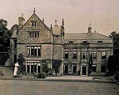
Brymbo Hall Brymbo Hall is one of Britain’s lost houses. It was the residence of industrialist and ironmaster John “Iron-Mad” Wilkinson. It is reputed to have been partly built to the designs of Inigo Jones.
Wrexham-Rhos transmitting station The Wrexham-Rhos transmitting station is a digital television relay of Moel-y-Parc. It is a free-standing lattice tower structure serving around 85,000 homes. It was constructed to coincide with the 1977 National Eisteddfod. It initially provided S4C and BBC One Wales, later joined by HTV Wales in 1997.
Rhosddu Rhosddu (Welsh pronunciation) is a local government community in Wrexham County Borough, Wales. At the 2011 Census, the population of the community was 6,840 and 11.8% of people aged 3+ spoke Welsh.
Wrexham General railway station Wrexham General is the main railway station in north-east Wales. The station was first opened in 1846 and expanded in 1912. It is currently operated by Transport for Wales, but services are also provided by Avanti West Coast.
Wrexham County Borough Wrexham County Borough is a principal area with county borough status in the preserved county of Clwyd, Wales. The county borough was formed on 1 April 1996 and has a population of nearly 135,000 inhabitants. The area has strong links with coal-mining and has only two urban towns, Chirk and Holt.
Llwyn Isaf Llwyn Isaf (“lower grove”) is a green space in the centre of Wrexham. It is surrounded on two sides by the town’s guildhall and on another by the Library Arts Centre. The space is most popular with students from Yale College.
Gresford Colliery Gresford Colliery was a coal mine located a mile from the North Wales village of Greffford, near Wrexham. The mine was a one-mile-long mine located near the village of Gresford.
A. N. Palmer Centre for Local Studies and Archives A.N. Palmer Centre for Local Studies and Archives holds archives for the town of Wrexham. The centre is named after local historian Alfred Neobard Palmer.
Visit Gwersyllt plaques
0 plaques hereGwersyllt has 0 physical plaques in tourist plaque schemes for you to explore via Walkfo Gwersyllt plaques audio map when visiting. Plaques like National Heritage’s “Blue Plaques” provide visual geo-markers to highlight points-of-interest at the places where they happened – and Walkfo’s AI has researched additional, deeper content when you visit Gwersyllt using the app. Experience the history of a location when Walkfo local tourist guide app triggers audio close to each Gwersyllt plaque. Currently No Physical Plaques.
Experience Gwersyllt audio walks & tours
Walkfo guides for things to do / places to visit in Gwersyllt allows exploration as you would do an art gallery or museum. Walk close to one of Gwersyllt’s 63 historic places & our digital tour guide will create an audio story for that spot. With headphone connected, you can explore Gwersyllt freely by foot, bike or bus – with your own personal tour guide in your pocket.
Explore Gwersyllt Map App
Our visit Gwersyllt map shows you things-to-do & places you can visit in Gwersyllt & surrounding areas using the Walkfo digital audio tour guide app. Each spot has plaque, building, street or area information on history, culture or tourism.
You can set your Walkfo’s Gwersyllt tourist map to find historic & tourism spots within 1km, 3km & 5km of the Gwersyllt centre, depending on how far you plan to explore whilst you visit Gwersyllt area at LONG:-3.021, LAT:53.076.
Walkfo App
Walkfo
Walkfo is free to download & use (for a limited time period), so if you are looking to explore Gwersyllt, go to your App Store to search for “Walkfo” or follow a links below and install on your mobile phone. Walkfo is designed for use with headphones or AirPods, so you can walk & explore whilst learning about the things around you without digital distraction.
Things to do & visit in Gwersyllt / surrounding areas
● Hope, Flintshire ● Rhydyn Hall ● Abermorddu ● Cefn-y-bedd ● River Cegidog ● Borras Park ● Borras ● The Flash (lake) ● Ffrith ● Brymbo Hall ● Brymbo Steelworks ● Sydallt ● Garden Village, Wrexham ● Rhosddu Recreation Ground ● Stansty ● Wheatsheaf Junction ● Rhosddu ● Rhosrobin ● Wrexham Glyndŵr University ● Pandy, Wrexham ● Racecourse Ground ● Turf Hotel ● Wrexham County Borough ● Plas Coch ● Llwyn Isaf ● Gresford Colliery ● Denbighshire Coalfield ● Wrexham Cathedral ● A. N. Palmer Centre for Local Studies and Archives ● Wrexham
● Wrexham Town Centre ● Wrexham Maelor Hospital ● Croes Newydd ● Bellevue Park, Wrexham ● Moss Valley, Wrexham ● Summerhill, Wrexham ● Moss Valley Branch ● Ysgol Clywedog ● New Broughton, Wrexham ● Heart Wirral ● Gwersyllt ● Bradley, Wrexham ● Ysgol Bryn Alyn ● Bryn Offa ● Heart North Wales Coast ● Capital North West and Wales ● Brickfield Rangers F.C. ● Broughton, Wrexham ● Brynteg, Wrexham ● Pentre Broughton ● Alyn Waters ● Southsea, Wrexham ● Brymbo F.C. ● Tanyfron ● All Saints’ Church, Gresford ● Chwarel Singret ● Llay Welfare F.C. ● Acton, Wrexham ● Brymbo ● Gresford disaster ● Gresford
Getting to / around Gwersyllt – transport link, station & street map
Getting around in Gwersyllt using public transportation may include road, street, train, underground, bus or tram transport options. Walkfo has identified the following Gwersyllt places with historic / cultural / factual content when you visit:
Local Gwersyllt Public Transport Stations
Gwersyllt Notable Streets & Road Destinations
Caergwrle railway station
Cefn-y-Bedd railway station
Ffrith railway station
Brymbo West Crossing Halt railway station
Pentresaeson Halt railway station
Brymbo railway station (Great Central Railway)
Wrexham-Rhos transmitting station
Brymbo railway station (Great Western Railway)
Moss Halt railway station
Rhosddu Halt railway station
Rhosrobin Halt railway station
Wrexham General railway station
Wrexham bus station
Wrexham Central railway station
Highfield Road Halt railway station
Gwersyllt railway station
Gatewen Halt railway station
Moss and Pentre railway station
Pentre Broughton Halt railway station
New Broughton Road Halt railway station
Gwersyllt Hill Halt railway station
The Lodge Halt railway station
Plas Power railway station (Wrexham, Mold and Connah’s Quay Railway)
Plas Power railway station (Wrexham and Minera Railway)
Gresford railway station
[transportsummary]
Local Gwersyllt historians & Gwersyllt tour guides
Trying to encourage visitors to Gwersyllt? Walkfo has millions audio places already available but Walkfo Creator gives Gwersyllt’s places, attractions & landmarks ability to create their own unique outdoor audio museums & using our simple & easy to use Walkfo Creator. – Creating a new audio experience for your Gwersyllt place is free* and quick (15+ minutes if you prepare text content) to use, with Walkfo Creator doing the hard work of generating AI audio files for geo-spots from the text you provide with a simply click on a map. – The 100 Amazing Gwersyllt Places is just one example of an outdoor museum created using Walkfo Creator (pictured to the left) for people to safely explore during Covid-19 times whilst visiting a city. Our tool is open to tourism organisations, travel destinations & National Trust locations to create their own audio walks to offer free when people visit Gwersyllt destinations. – Walkfo itself is looking to partner with websites offering things-to-do / what’s on events listings to enhance the content of our ‘visit-Gwersyllt’ web pages (for example: www.visitGwersyllt.com). If you are interested in partnering, please contact us to discuss options.
* Walkfo Creator is free to use for a limited number of audio spots within a map with a license fee applicable when more than 20 audio spots within location walk are created. v1.1336
 Visit Gwersyllt places using Walkfo for free guided tours of the best Gwersyllt places to visit. A unique way to experience Gwersyllt’s places, Walkfo allows you to explore Gwersyllt as you would a museum or art gallery with audio guides.
 You can visit Gwersyllt places with Walkfo Gwersyllt to hear history at Gwersyllt’s places whilst walking around using the free digital tour app. Walkfo Gwersyllt has 63 places to visit in our interactive Gwersyllt map, with amazing history, culture & travel facts you can explore the same way you would at a museum or art gallery with information audio headset. With Walkfo, you can travel by foot, bike or bus throughout Gwersyllt, being in the moment, without digital distraction or limits to a specific walking route. Our historic audio walks, National Trust interactive audio experiences, digital tour guides for English Heritage locations are available at Gwersyllt places, with a AI tour guide to help you get the best from a visit to Gwersyllt & the surrounding areas.


 0
0


 Trying to encourage visitors to Gwersyllt?