Welcome to Visit Glossop Places
The Walkfo guide to things to do & explore in Glossop
 Visit Glossop places using Walkfo for free guided tours of the best Glossop places to visit. A unique way to experience Glossop’s places, Walkfo allows you to explore Glossop as you would a museum or art gallery with audio guides.
Visiting Glossop Walkfo Preview
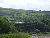
Glossop is a market town in the Borough of High Peak, Derbyshire, England. It is 15 miles east of Manchester, 24 miles north-west of Sheffield and 32 miles north of Matlock. The name Glossop refers to the small hamlet that gave its name to an ancient parish recorded in the Domesday Book of 1086. When you visit Glossop, Walkfo brings Glossop places to life as you travel by foot, bike, bus or car with a mobile phone & headphones.
Glossop Places Overview: History, Culture & Facts about Glossop
Visit Glossop – Walkfo’s stats for the places to visit
With 43 audio plaques & Glossop places for you to explore in the Glossop area, Walkfo is the world’s largest heritage & history digital plaque provider. The AI continually learns & refines facts about the best Glossop places to visit from travel & tourism authorities (like Wikipedia), converting history into an interactive audio experience.
Glossop history
Toponymy and definition
Glossop is thought to be of Anglo-Saxon origin, named during the Angles’ settlement in the 7th century. The name derived from Glott’s Hop, where hop could mean a valley, a small valley in a larger valley system, or a piece of land enclosed by marshes. From a small settlement it became an ancient parish, manor, borough and township.
Roman
There is evidence of a Bronze Age burial site on Shire Hill (near Old Glossop) and other possibly prehistoric remains at Torside (on the slopes of Bleaklow) The Romans arrived in 78 AD. The area was within the territory of the Brigantes tribe, whose main base was in Yorkshire. In the late 1st century the Romans built a fort, Ardotalia, on high ground above the river in present-day Gamesley.
Medieval
In 1157 King Henry II gave the manor of Glossop to Basingwerk Abbey. At the dissolution of the monasteries in 1537 it was given to the Talbot family, later Earls of Shrewsbury. In 1606 it came into the ownership of the Howard family, the Dukes of Norfolk.
Industrial and civic history
The medieval economy was based on sheep pasture and the production of wool by farmers who were tenants of the Abbot of Basingwerk and later the Talbot family. During the Industrial Revolution of the 18th century Glossop became a centre for cotton spinning. A good transport network between Liverpool and Glossop brought in imported cotton which was spun by a labour force with wool spinning skills. The climate of Glossopdale provided abundant soft water that was used to power mills and finish the cloth, and also gave the humidity necessary to spin cotton under tension. Initial investment was provided by the Dukes of Norfolk. By 1740, cotton in an unspun form had been introduced to make fustians and lighter cloths. The first mills in Glossop were woollen mills. In 1774, Richard Arkwright opened a mill at Cromford. He developed the factory system and patented machines for spinning cotton and carding. In 1785, his patents expired and many people copied Arkwright’s system and his patents, exemplified by the Derwent Valley Mills. By 1788 there were over 200 Arkwright-type mills in Britain. At the same time there were 17 cotton mills in Derbyshire, principally in Glossop. By 1831 there were at least 30 mills in Glossopdale, none of which had more than 1,000 spindles. The mill owners were local men: the Wagstaffs and Hadfields were freeholders from Whitfield; the Shepleys, Shaws, Lees, Garlicks and Platts had farmed the dale. The Sidebottoms were from Hadfield, the Thornleys were carpenters and John Bennet and John Robinson were clothiers. John Wood of Marsden came from Manchester in 1819 and bought existing woollen mills which he expanded. These were the Howard Town mills. Francis Sumner was a Catholic whose family had connections with Matthew Ellison, Howard’s agent. He built Wren Nest Mill. The Sidebottoms built the Waterside Mill at Hadfield. In 1825, John Wood installed the first steam engine and power looms. Sumner and Sidebottom followed suit and the three mills, Wren Nest, Howardtown and Waterside, became very large vertical combines (a vertical combine was a mill that both spun the yarn and then used it to weave cloth). With the other major families, the Shepleys, Rhodes and Platts, they dominated the dale. In 1884, the six had 82% of the spinning capacity with 892,000 spindles and 13,571 looms. Glossop was a town of very large calico mills. The calico printing factory of Edmund Potter (located in Dinting Vale) in the 1850s printed 2½ million pieces of printed calico, of which 80% was for export. The paper industry was created by Edward Partington who, as Olive and Partington, bought the Turn Lee Mill in 1874 to produce high-quality paper from wood pulp by the sulphite method. He expanded rapidly with mills in Salford and Barrow-in-Furness. He merged with Kellner of Vienna and was created Lord Doverdale in 1917. He died in 1925; his factories in Charlestown created nearly 1,000 jobs. Lord Bernard Edward Howard, 12th Duke of Norfolk rebuilt the old parish church in 1831, built All Saints Roman Catholic chapel in 1836, improved the Hurst Reservoir in 1837, and built the Town Hall, whose foundation stone was laid on Coronation Day 1838. The Sheffield, Ashton-under-Lyne and Manchester Railway came to Dinting in 1842, but it was the 13th Duke of Norfolk who built the spur line to Howard Town, so that coal could be brought from the collieries at Dukinfield. Glossop railway station bears the lion, the symbol of the Norfolks. Many of the street- and placenames in Glossop derive from the names and titles of the Dukes of Norfolk, such as Norfolk Square, and a cluster of residential streets off Norfolk Street that were named after Lord Henry Charles Fitzalan Howard, the 13th Duke of Norfolk, the first Catholic MP since the Reformation. (His second son was created 1st Baron Howard of Glossop and was ancestor of the post-1975 dukes.) A two-storey Township Workhouse was built between 1832 and 1834 on Bute Street (grid reference SK043952). Its administration was taken over by Glossop Poor Law Union in December 1837. The workhouse buildings included a 40-bed infirmary, piggeries and casual wards for vagrants. The workhouse later became Glossop Public Assistance Institution and from 1948 the N.H.S. Shire Hill Hospital. The mill owners, Catholics, Anglican, Methodist and Unitarian, built reading rooms and chapels. They worked together and worshipped together with their workers. The Woods, Sidebottoms and Shepleys were Anglicans and hence Tory, and they dominated every vestry, which was the only form of local government before 1866. They built four churches St James’s, Whitfield in 1846, St Andrew’s, Hadfield in 1874, Holy Trinity, Dinting in 1875 and St Luke’s, Glossop. Francis Sumner and the Ellisons and Norfolks were Catholic and built St Charles’s, Hadfield and St Mary’s, Glossop. The smaller mill owners were Dissenters and congregated at Littlemoor Independent Chapel built in Hadfield in 1811, but they later built a further eleven chapels. For decades there was rivalry between Edward Partington, his friend Herbert Rhodes, and the Woods and Sidebottoms. The Woods built the public baths and laid out the park. Partington built the library. Partington built the cricket pavilion, so Samuel Hill-Wood sponsored the football club that for one season, 1889–1890, played in League Division One. He and his descendants went on to be chairmen of the London club, Arsenal. He was MP for High Peak from 1910 to 1929. Edward’s son, Oswald, was MP for High Peak from 1900 to 1910. Ann Kershaw Woods devoted herself to Anglican education and had schools built. In 1851, 38% of the men and 27% of the women were employed in cotton; the only alternative employment was agriculture, building, or labouring on the railway. Consequently, the town was vulnerable to interruptions in the supply of cotton or the export trade. The American Civil War caused the cotton famine of 1861–64. The mill owners met together and put in place a relief programme through which they supplied food, clogs and coal to their employees. Howard increased the workforce on his estate, and public works (such as improving the domestic water supply) were undertaken. They provided unsecured loans to the workers until the cotton returned. The relationship between the owners and men was one of paternal benevolence. They lived in the same community and worshipped in the same churches. The mill owners were the local aldermen, the church elders and led the sports teams. In the Luddite and Chartist times and the period following Peterloo, Glossop was virtually unaffected, despite its proximity to Hyde, a radical hotbed. In the ‘4s 2d or swing strike’ it was incomers from Ashton who stopped the Glossop mills. The rivalry in Glossop was not based on class but on religious groups.
Modern (20th and 21st centuries)

The decline of cotton spinning has resulted in the closure of many of the town’s mills. The Howard family sold the Glossop Estate in 1925 and donated large areas to the people of Glossop. The recession of 1929 hit Glossop very hard: in 1929 the unemployment rate was 14%, and in 1931 it was 55% in Hadfield. The Second World War changed this: military stores, metals, machine tools, munitions, rubber and essential industries moved into the empty factories.
Plans

Glossop has been included as pilot in the Liveability scheme. It has drawn up the Glossop Vision masterplan for the improvement and gentrification of the town. This is being partially funded by the Heritage Lottery Fund. The mills have become a retail development with housing, trees are to be planted along the A57.
Glossop culture & places
Performing arts
Glossop & District Choral Society is a community choir founded in 1949. Partington Theatre is an amateur theatre with a 120-seat venue in the centre of the town. Glossop Operatic and Dramatic Society was established in 1976.
Community events
Glossop Victorian Weekend was the biggest weekend event in Glossop and featured on the BBC’s Songs of Praise. The Victorian Weekend included many activities, including a Grand Victorian Costume Competition and a Shop Window Competition. Glossop has become quite well known musically for staging jazz and world music festivals.
Glossop landmarks
Glossop Town Hall and Market Hall was designed in Italianate style by Sheffield architects Weightman and Hadfield. The first mention of a church in Glossop is in the charter of 1157 conferring the manor of Glossop on Basingwerk Abbey. The present-day fabric of the parish church of All Saints is mostly of the 20th century.
Glossop geography / climate
Glossop lies on Glossop Brook, a tributary of the River Etherow, in the area of peat moorland commonly known as the Dark Peak. It nestles in the foothills of the Pennines, with Bleaklow to the north-east and Kinder Scout to the south. The moors are cut by many deep V-shaped valleys known as cloughs, each formed by a stream known as a brook.
Geology

Glossopdale was the product of glacial action in the last glaciation period that exploited the weakened rocks. The layers of sandstone, mudstones and shale in the bedrock act as an aquifer to feed the springs. The valley bottoms have a thin deposit of boulder clay.
Climate
Glossop experiences a temperate maritime climate, with relatively cool summers and mild winters. There is regular but generally light precipitation throughout the year. Glossop has a history of flash flooding, the most recent being in 2002 when High Street West was flooded to a depth of 3 feet (1 m)
Why visit Glossop with Walkfo Travel Guide App?
 You can visit Glossop places with Walkfo Glossop to hear history at Glossop’s places whilst walking around using the free digital tour app. Walkfo Glossop has 43 places to visit in our interactive Glossop map, with amazing history, culture & travel facts you can explore the same way you would at a museum or art gallery with information audio headset. With Walkfo, you can travel by foot, bike or bus throughout Glossop, being in the moment, without digital distraction or limits to a specific walking route. Our historic audio walks, National Trust interactive audio experiences, digital tour guides for English Heritage locations are available at Glossop places, with a AI tour guide to help you get the best from a visit to Glossop & the surrounding areas.
“Curated content for millions of locations across the UK, with 43 audio facts unique to Glossop places in an interactive Glossop map you can explore.”
Walkfo: Visit Glossop Places Map
43 tourist, history, culture & geography spots
Glossop historic spots | Glossop tourist destinations | Glossop plaques | Glossop geographic features |
| Walkfo Glossop tourism map key: places to see & visit like National Trust sites, Blue Plaques, English Heritage locations & top tourist destinations in Glossop | |||
Best Glossop places to visit
Glossop has places to explore by foot, bike or bus. Below are a selection of the varied Glossop’s destinations you can visit with additional content available at the Walkfo Glossop’s information audio spots:

Manor Park, Glossop
Manor Park is a city park in Glossop, Derbyshire, England. Manor Park was built in the 1930s. It is located in Manor Park, Glossop.

Shire Hill Hospital
Shire Hill Hospital was a healthcare facility in Bute Street, Glossop, Derbyshire. It was managed by Tameside and Glossop Integrated Care NHS Foundation Trust.
Visit Glossop plaques
 3
3
plaques
here Glossop has 3 physical plaques in tourist plaque schemes for you to explore via Walkfo Glossop plaques audio map when visiting. Plaques like National Heritage’s “Blue Plaques” provide visual geo-markers to highlight points-of-interest at the places where they happened – and Walkfo’s AI has researched additional, deeper content when you visit Glossop using the app. Experience the history of a location when Walkfo local tourist guide app triggers audio close to each Glossop plaque. Explore Plaques & History has a complete list of Hartlepool’s plaques & Hartlepool history plaque map.


 Trying to encourage visitors to Glossop?