Welcome to Visit Giffnock Places
The Walkfo guide to things to do & explore in Giffnock
 Visit Giffnock places using Walkfo for free guided tours of the best Giffnock places to visit. A unique way to experience Giffnock’s places, Walkfo allows you to explore Giffnock as you would a museum or art gallery with audio guides.
Visiting Giffnock Walkfo Preview
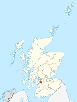
Giffnock is the administrative centre of East Renfrewshire in the Central Lowlands of Scotland. It lies 3.7 miles (6.0 km) east of Barrhead, 5.6 miles east-southeast of Paisley and 5.3 miles (8.5 km) northwest of East Kilbride, at the southwest of the Greater Glasgow conurbation. The town has been named amongst the most affluent areas in Scotland. When you visit Giffnock, Walkfo brings Giffnock places to life as you travel by foot, bike, bus or car with a mobile phone & headphones.
Giffnock Places Overview: History, Culture & Facts about Giffnock
Visit Giffnock – Walkfo’s stats for the places to visit
With 93 audio plaques & Giffnock places for you to explore in the Giffnock area, Walkfo is the world’s largest heritage & history digital plaque provider. The AI continually learns & refines facts about the best Giffnock places to visit from travel & tourism authorities (like Wikipedia), converting history into an interactive audio experience.
Giffnock history
First written mention of Giffnock came in 1530, when James V presented Rockend (Ruken) Mill and the surrounding lands to Hugh Montgomerie, 1st Earl of Eglinton. The settlement first appeared as Gisnock, in an atlas created by Dutch cartographer Joan Blaeu in 1654, the first atlas of Scotland.
Industry
In 1835, the first sandstone quarry in Giffnock opened in Glasgow. At its peak, there were four quarries, three surface quarries and one underground quarry. The quarries produced two types of sandstone: “liver rock” and “moor rock” Coal mining was also carried out between 1850 and 1926.
Urbanisation and expansion
The opening of Giffnock railway station in 1866 allowed business people to build sandstone villas and commute daily to the city. The growth of the town was furthered in 1905 by the arrival of the first Glasgow Corporation Tramways tram in the town. During the great housing boom of the late 1930s, as many as 3,000 dwellings were constructed, and the population rose dramatically.
Giffnock geography / climate

Giffnock is 3.7 miles (6.0 km) east of Barrhead, 5.3 miles (8.5 km) northwest of East Kilbride. The town lies in the Central Lowlands and is contiguous with Glasgow. It is at edge of the area that defines the basin that Glasgow has developed within.
Why visit Giffnock with Walkfo Travel Guide App?
 You can visit Giffnock places with Walkfo Giffnock to hear history at Giffnock’s places whilst walking around using the free digital tour app. Walkfo Giffnock has 93 places to visit in our interactive Giffnock map, with amazing history, culture & travel facts you can explore the same way you would at a museum or art gallery with information audio headset. With Walkfo, you can travel by foot, bike or bus throughout Giffnock, being in the moment, without digital distraction or limits to a specific walking route. Our historic audio walks, National Trust interactive audio experiences, digital tour guides for English Heritage locations are available at Giffnock places, with a AI tour guide to help you get the best from a visit to Giffnock & the surrounding areas.
“Curated content for millions of locations across the UK, with 93 audio facts unique to Giffnock places in an interactive Giffnock map you can explore.”
Walkfo: Visit Giffnock Places Map
93 tourist, history, culture & geography spots
Giffnock historic spots | Giffnock tourist destinations | Giffnock plaques | Giffnock geographic features |
| Walkfo Giffnock tourism map key: places to see & visit like National Trust sites, Blue Plaques, English Heritage locations & top tourist destinations in Giffnock | |||
Best Giffnock places to visit
Giffnock has places to explore by foot, bike or bus. Below are a selection of the varied Giffnock’s destinations you can visit with additional content available at the Walkfo Giffnock’s information audio spots:
 | Mansewood Mansewood (Scots: Mansewid) is a residential district in the Scottish city of Glasgow. It is situated south of the River Clyde and is surrounded by the districts of Eastwood, Hillpark, Pollokshaws in Glasgow and Thornliebank and Giffnock. |
 | East Renfrewshire East Renfrewshire is one of 32 council areas of Scotland . Until 1975, it formed part of the county of Renfreyshire for local government purposes . It was formed in 1996 as a successor to the Eastwood district, with the Levern Valley being annexed . |
 | Muirend Muirend is situated about 4 miles (6.5 km) south of Glasgow city centre. The G44 postcode was rated as the most desirable area of Scotland to live in. Neighbouring areas include Cathcart, Merrylee and Newlands. |
 | Cathcart Cemetery Cathcart Cemetery is a cemetery in East Renfrewshire, Scotland, which was opened in 1878 . It is named after the nearby neighbourhood of Cathcart on the southern outskirts of Glasgow, but does not actually fall within the city boundaries . |
 | Strathbungo Strathbungo grew up as a small village built along the Pollokshaws Road, one of the main arteries leading southwards from the centre of Glasgow, adjoined by the Camphill Estate, now part of Queens Park. The feudal superiors, the Maxwells of Pollok, preferred the name Marchtown, and this name is seen on some old maps. |
Visit Giffnock plaques
 5
5
plaques
here Giffnock has 5 physical plaques in tourist plaque schemes for you to explore via Walkfo Giffnock plaques audio map when visiting. Plaques like National Heritage’s “Blue Plaques” provide visual geo-markers to highlight points-of-interest at the places where they happened – and Walkfo’s AI has researched additional, deeper content when you visit Giffnock using the app. Experience the history of a location when Walkfo local tourist guide app triggers audio close to each Giffnock plaque. Explore Plaques & History has a complete list of Hartlepool’s plaques & Hartlepool history plaque map.


 Trying to encourage visitors to Giffnock?